![](/images/other/stat-length.png)
![Tocht Stappen Mazières-de-Touraine - Sentier n° 2 de Mazières de Touraine - Photo](https://media.geolcdn.com/t/1900/400/ext.pjpeg?maxdim=2&url=https%3A%2F%2Fservices.sitytrail.com%2FGeolivesWS%2FDownloadMedia.ashx%3FTrailID%3D112260%26Media%3D10242_4.jpg)
Sentier n° 2 de Mazières de Touraine
tracegps
Gebruiker
![Lengte](/images/other/stat-length.png)
Lengte
9,2 km
![Max. hoogte](https://static1.geolcdn.com/siteimages/upload/files/1508320355ic_sort_altitude_max_24dp.png)
Max. hoogte
108 m
![Positief hoogteverschil](https://static1.geolcdn.com/siteimages/upload/files/1508320355ic_sort_den_pos_24dp.png)
Positief hoogteverschil
87 m
![Km-Effort](/images/other/stat-length.png)
Km-Effort
10,3 km
![Min. hoogte](https://static1.geolcdn.com/siteimages/upload/files/1508320355ic_sort_altitude_min_24dp.png)
Min. hoogte
59 m
![Negatief hoogteverschil](https://static1.geolcdn.com/siteimages/upload/files/1508320355ic_sort_den_neg_24dp.png)
Negatief hoogteverschil
88 m
![Boucle](https://static1.geolcdn.com/siteimages/upload/files/16400158638029165_repeat_loop_refresh_sync_direction_icon.png)
Boucle
Ja
Datum van aanmaak :
2014-12-10 00:00:00.0
Laatste wijziging :
2014-12-10 00:00:00.0
![Stappen](https://static1.geolcdn.com/sitytour/trail-icons/101.png)
2h19
Moeilijkheid : Medium
![Scan deze QR-code om de tocht te openen in de SityTrail-applicatie](https://capi.geolives.com/qq0zvz2zws4bq2lad0pu/sitytour/trails/112260/qr.png?size=200)
Gratisgps-wandelapplicatie
Over ons
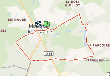
Tocht Stappen van 9,2 km beschikbaar op Centre-Val de Loire, Indre-et-Loire, Mazières-de-Touraine. Deze tocht wordt voorgesteld door tracegps.
Beschrijving
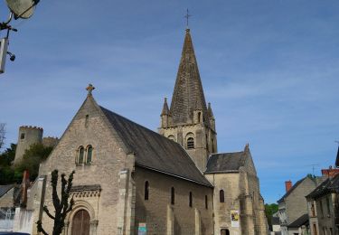
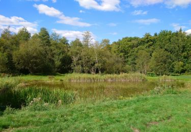
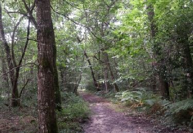
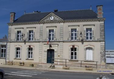
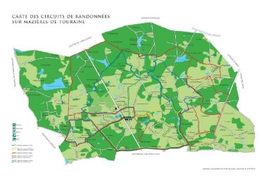
Circuit proposé par la Commune de Mazières de Touraine. Départ de l’église de Mazières de Touraine. Retrouvez le la carte des circuits sur le site de la mairie.
Plaatsbepaling
Land:
France
Regio :
Centre-Val de Loire
Departement/Provincie :
Indre-et-Loire
Gemeente :
Mazières-de-Touraine
Locatie:
Unknown
Vertrek:(Dec)
Vertrek:(UTM)
305734 ; 5250965 (31T) N.
Opmerkingen
Wandeltochten in de omgeving
![Tocht Stappen Cinq-Mars-la-Pile - Cinq-Mars-la-Pile - Langeais - 14km 205m 3h05 - 2024 02 14 - Photo](https://media.geolcdn.com/t/375/260/bfe42b2e-405a-46df-8533-fbac70b0d338.jpg&format=jpg&maxdim=2)
![Stappen Stappen](https://static1.geolcdn.com/sitytour/trail-icons/101.png)
Cinq-Mars-la-Pile - Langeais - 14km 205m 3h05 - 2024 02 14
Stappen
Gemakkelijk
Cinq-Mars-la-Pile,
Centre-Val de Loire,
Indre-et-Loire,
France
![](/images/other/stat-length.png)
14 km | 16,7 km-effort
3h 5min
![](https://static1.geolcdn.com/siteimages/upload/files/16400158638029165_repeat_loop_refresh_sync_direction_icon.png)
Ja
![Tocht Stappen Cléré-les-Pins - Cléré-les-Pins - GRP Castelvalérie - 13.4km 90m 2h50 - 2023 03 25 - Photo](https://media.geolcdn.com/t/375/260/7fa6ca64-cfb4-4459-9a76-2d0948898d97.jpg&format=jpg&maxdim=2)
![Stappen Stappen](https://static1.geolcdn.com/sitytour/trail-icons/101.png)
Cléré-les-Pins - GRP Castelvalérie - 13.4km 90m 2h50 - 2023 03 25
Stappen
Gemakkelijk
Cléré-les-Pins,
Centre-Val de Loire,
Indre-et-Loire,
France
![](/images/other/stat-length.png)
13,4 km | 14,6 km-effort
2h 50min
![](https://static1.geolcdn.com/siteimages/upload/files/16400158638029165_repeat_loop_refresh_sync_direction_icon.png)
Ja
![Tocht Stappen Cinq-Mars-la-Pile - Cinq-Mars-la-Pile - le Mortier Rougeau - 19.5km 265m 4h30 - 2022 04 17 - Photo](https://media.geolcdn.com/t/375/260/f382cab4-57ba-447e-b146-a35d4860c6b9.jpg&format=jpg&maxdim=2)
![Stappen Stappen](https://static1.geolcdn.com/sitytour/trail-icons/101.png)
Cinq-Mars-la-Pile - le Mortier Rougeau - 19.5km 265m 4h30 - 2022 04 17
Stappen
Gemakkelijk
Cinq-Mars-la-Pile,
Centre-Val de Loire,
Indre-et-Loire,
France
![](/images/other/stat-length.png)
19,7 km | 23 km-effort
4h 30min
![](https://static1.geolcdn.com/siteimages/upload/files/16400158638029165_repeat_loop_refresh_sync_direction_icon.png)
Ja
![Tocht Stappen Mazières-de-Touraine - Mazières-de-Touraine - Ruisseau du Breuil - 17.3km 200m 4h20 - 2020 09 09 - Photo](https://media.geolcdn.com/t/375/260/f1d013cb-af38-48a9-aea1-dfc2388ff089.jpg&format=jpg&maxdim=2)
![Stappen Stappen](https://static1.geolcdn.com/sitytour/trail-icons/101.png)
Mazières-de-Touraine - Ruisseau du Breuil - 17.3km 200m 4h20 - 2020 09 09
Stappen
Gemakkelijk
Mazières-de-Touraine,
Centre-Val de Loire,
Indre-et-Loire,
France
![](/images/other/stat-length.png)
17,3 km | 19,9 km-effort
4h 20min
![](https://static1.geolcdn.com/siteimages/upload/files/16400158638029165_repeat_loop_refresh_sync_direction_icon.png)
Ja
![Tocht Stappen Mazières-de-Touraine - maître jaune et variante - Photo](https://media.geolcdn.com/t/375/260/ext.jpg?maxdim=2&url=https%3A%2F%2Fstatic1.geolcdn.com%2Fsiteimages%2Fupload%2Ffiles%2F1553511878bg_sport_marche.png)
![Stappen Stappen](https://static1.geolcdn.com/sitytour/trail-icons/101.png)
maître jaune et variante
Stappen
Heel gemakkelijk
(1)
Mazières-de-Touraine,
Centre-Val de Loire,
Indre-et-Loire,
France
![](/images/other/stat-length.png)
11,5 km | 13,1 km-effort
2h 30min
![](https://static1.geolcdn.com/siteimages/upload/files/16400158638029165_repeat_loop_refresh_sync_direction_icon.png)
Ja
![Tocht Stappen Mazières-de-Touraine - maziere de Touraine - Photo](https://media.geolcdn.com/t/375/260/ext.jpg?maxdim=2&url=https%3A%2F%2Fservices.sitytrail.com%2FGeolivesWS%2FDownloadMedia.ashx%3FTrailID%3D332574%26Media%3Dfix__20140809125412.jpg)
![Stappen Stappen](https://static1.geolcdn.com/sitytour/trail-icons/101.png)
maziere de Touraine
Stappen
Medium
Mazières-de-Touraine,
Centre-Val de Loire,
Indre-et-Loire,
France
![](/images/other/stat-length.png)
16,1 km | 18,5 km-effort
3h 33min
![](https://static1.geolcdn.com/siteimages/upload/files/16400158638029165_repeat_loop_refresh_sync_direction_icon.png)
Ja
![Tocht Stappen Mazières-de-Touraine - Sentier de randonnée n° 5 bis de Mazières-de-Touraine - Photo](https://media.geolcdn.com/t/375/260/ext.jpg?maxdim=2&url=https%3A%2F%2Fservices.sitytrail.com%2FGeolivesWS%2FDownloadMedia.ashx%3FTrailID%3D317505%26Media%3D16742_3.jpg)
![Stappen Stappen](https://static1.geolcdn.com/sitytour/trail-icons/101.png)
Sentier de randonnée n° 5 bis de Mazières-de-Touraine
Stappen
Moeilijk
Mazières-de-Touraine,
Centre-Val de Loire,
Indre-et-Loire,
France
![](/images/other/stat-length.png)
21 km | 24 km-effort
5h 15min
![](https://static1.geolcdn.com/siteimages/upload/files/16400158638029165_repeat_loop_refresh_sync_direction_icon.png)
Ja
![Tocht Stappen Mazières-de-Touraine - Sentier de randonnée n° 4 de Mazières-de-Touraine - Photo](https://media.geolcdn.com/t/375/260/ext.jpg?maxdim=2&url=https%3A%2F%2Fservices.sitytrail.com%2FGeolivesWS%2FDownloadMedia.ashx%3FTrailID%3D317431%26Media%3D16666_1.jpg)
![Stappen Stappen](https://static1.geolcdn.com/sitytour/trail-icons/101.png)
Sentier de randonnée n° 4 de Mazières-de-Touraine
Stappen
Moeilijk
Mazières-de-Touraine,
Centre-Val de Loire,
Indre-et-Loire,
France
![](/images/other/stat-length.png)
30 km | 33 km-effort
7h 30min
![](https://static1.geolcdn.com/siteimages/upload/files/16400158638029165_repeat_loop_refresh_sync_direction_icon.png)
Ja
![Tocht Stappen Mazières-de-Touraine - Sentier de randonnée n° 3 de Mazières de Touraine - Photo](https://media.geolcdn.com/t/375/260/ext.jpg?maxdim=2&url=https%3A%2F%2Fservices.sitytrail.com%2FGeolivesWS%2FDownloadMedia.ashx%3FTrailID%3D112262%26Media%3D10244_4.jpg)
![Stappen Stappen](https://static1.geolcdn.com/sitytour/trail-icons/101.png)
Sentier de randonnée n° 3 de Mazières de Touraine
Stappen
Gemakkelijk
(1)
Mazières-de-Touraine,
Centre-Val de Loire,
Indre-et-Loire,
France
![](/images/other/stat-length.png)
3 km | 3,5 km-effort
45min
![](https://static1.geolcdn.com/siteimages/upload/files/16400158638029165_repeat_loop_refresh_sync_direction_icon.png)
Ja