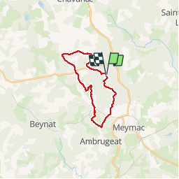
![](/images/other/stat-length.png)
![Tocht Stappen Meymac - Le toit du Limousin 19 km - Meymac - Pays de Haute Corrèze - Photo](https://media.geolcdn.com/t/1900/400/ext.pjpeg?maxdim=2&url=https%3A%2F%2Fservices.sitytrail.com%2FGeolivesWS%2FDownloadMedia.ashx%3FTrailID%3D112247%26Media%3D10192_1.jpg)
Le toit du Limousin 19 km - Meymac - Pays de Haute Corrèze
tracegps
Gebruiker
![Lengte](/images/other/stat-length.png)
![Max. hoogte](https://static1.geolcdn.com/siteimages/upload/files/1508320355ic_sort_altitude_max_24dp.png)
![Positief hoogteverschil](https://static1.geolcdn.com/siteimages/upload/files/1508320355ic_sort_den_pos_24dp.png)
![Km-Effort](/images/other/stat-length.png)
![Min. hoogte](https://static1.geolcdn.com/siteimages/upload/files/1508320355ic_sort_altitude_min_24dp.png)
![Negatief hoogteverschil](https://static1.geolcdn.com/siteimages/upload/files/1508320355ic_sort_den_neg_24dp.png)
![Boucle](https://static1.geolcdn.com/siteimages/upload/files/16400158638029165_repeat_loop_refresh_sync_direction_icon.png)
![Stappen](https://static1.geolcdn.com/sitytour/trail-icons/101.png)
4h30
Moeilijkheid : Moeilijk
![Scan deze QR-code om de tocht te openen in de SityTrail-applicatie](https://capi.geolives.com/qq0zvz2zws4bq2lad0pu/sitytour/trails/112247/qr.png?size=200)
Gratisgps-wandelapplicatie
Over ons
Tocht Stappen van 19 km beschikbaar op Nieuw-Aquitanië, Corrèze, Meymac. Deze tocht wordt voorgesteld door tracegps.
Beschrijving
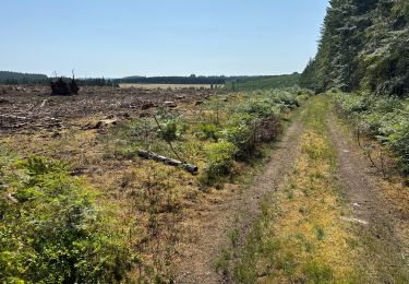
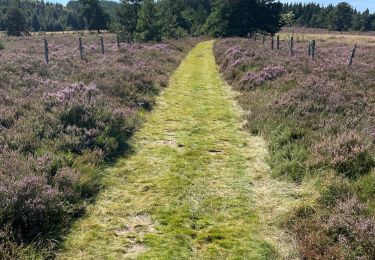
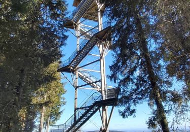
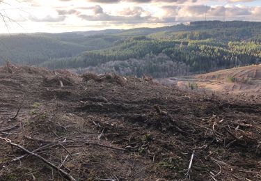
Le toit du Limousin 19 km - Meymac - Pays de Haute Corrèze Élevez vous sur la Montagne Limousine et venez découvrir cet océan de nature parsemé d’une multitude de petits villages pittoresques. Gravissez les chemins et observez au travers d’immenses fenêtres, percées au gré des coupes forestières, les horizons lointains qui s’ouvrent sur les Monts d’Auvergne, avec eu premier plan, les hauts plateaux Corréziens et les innombrables vallées où glissent les rivières… Descendez explorer les fonds humides où depuis des millénaires se « fabriquent » les tourbières. Tournez la tête à droite, à gauche, ici rien n’est pareil, ici tout est grandiose, ici vous respirez. Téléchargez la fiche du circuit sur le site du Conseil Général de la Corrèze. Renseignements : Office de Tourisme de Meymac 05.55.95.18.43
Plaatsbepaling
Opmerkingen
Wandeltochten in de omgeving
![Tocht Stappen Saint-Merd-les-Oussines - Le sentier des bruyères - Photo](https://media.geolcdn.com/t/375/260/488e30cf-5719-4904-be7c-482bc296e152.jpg&format=jpg&maxdim=2)
![Stappen Stappen](https://static1.geolcdn.com/sitytour/trail-icons/101.png)
Stappen
![](/images/other/stat-length.png)
![](https://static1.geolcdn.com/siteimages/upload/files/16400158638029165_repeat_loop_refresh_sync_direction_icon.png)
![Tocht Stappen Saint-Merd-les-Oussines - Autour de la Tourbière - Photo](https://media.geolcdn.com/t/375/260/ext.jpg?maxdim=2&url=https%3A%2F%2Fstatic1.geolcdn.com%2Fsiteimages%2Fupload%2Ffiles%2F1553511878bg_sport_marche.png)
![Stappen Stappen](https://static1.geolcdn.com/sitytour/trail-icons/101.png)
Stappen
![](/images/other/stat-length.png)
![](https://static1.geolcdn.com/siteimages/upload/files/16400158638029165_repeat_loop_refresh_sync_direction_icon.png)
![Tocht Stappen Meymac - Lestrade-La Vialle-Le Colomby - Photo](https://media.geolcdn.com/t/375/260/5ddeede1-0c7c-48f5-820b-c121b8dba3c5.jpg&format=jpg&maxdim=2)
![Stappen Stappen](https://static1.geolcdn.com/sitytour/trail-icons/101.png)
Stappen
![](/images/other/stat-length.png)
![](https://static1.geolcdn.com/siteimages/upload/files/16400158638029165_repeat_loop_refresh_sync_direction_icon.png)
![Tocht Stappen Meymac - Meymac_Davignac - Photo](https://media.geolcdn.com/t/375/260/ext.jpg?maxdim=2&url=https%3A%2F%2Fservices.sitytrail.com%2FGeolivesWS%2FDownloadMedia.ashx%3FTrailID%3D1079780%26Media%3Dfix__20181202113944.jpg)
![Stappen Stappen](https://static1.geolcdn.com/sitytour/trail-icons/101.png)
Stappen
![](/images/other/stat-length.png)
![](https://static1.geolcdn.com/siteimages/upload/files/16400158638029165_repeat_loop_refresh_sync_direction_icon.png)
![Tocht sport Saint-Merd-les-Oussines - F 2024?Longeyroux Lac Oussines - Photo](https://media.geolcdn.com/t/375/260/aa2d07db-3b65-4ec1-88c3-11e9ca3779dd.jpg&format=jpg&maxdim=2)
sport
![](/images/other/stat-length.png)
![](https://static1.geolcdn.com/siteimages/upload/files/16400158638029165_repeat_loop_refresh_sync_direction_icon.png)
![Tocht sport Saint-Merd-les-Oussines - Longeyroux Les Oussines - Photo](https://media.geolcdn.com/t/375/260/9abf5d9f-9b93-4ec8-90f0-993364c0b57e.jpg&format=jpg&maxdim=2)
sport
![](/images/other/stat-length.png)
![](https://static1.geolcdn.com/siteimages/upload/files/16400158638029165_repeat_loop_refresh_sync_direction_icon.png)
![Tocht Stappen Meymac - Tour du Mont Bessou. - Photo](https://media.geolcdn.com/t/375/260/54fd3e0e-a5d0-4a99-bc81-3c0bb4dbdefb.jpg&format=jpg&maxdim=2)
![Stappen Stappen](https://static1.geolcdn.com/sitytour/trail-icons/101.png)
Stappen
![](/images/other/stat-length.png)
![](https://static1.geolcdn.com/siteimages/upload/files/16400158638029165_repeat_loop_refresh_sync_direction_icon.png)
![Tocht Stappen Meymac - Montagne du Cloup, les Farges - Photo](https://media.geolcdn.com/t/375/260/3a8b1475-4c77-4191-b364-fff74de63b5d.jpg&format=jpg&maxdim=2)
![Stappen Stappen](https://static1.geolcdn.com/sitytour/trail-icons/101.png)
Stappen
![](/images/other/stat-length.png)
![](https://static1.geolcdn.com/siteimages/upload/files/16400158638029165_repeat_loop_refresh_sync_direction_icon.png)
![Tocht Stappen Meymac - Puy Baubière - Photo](https://media.geolcdn.com/t/375/260/f59ac1de-9b24-4d1e-8cc0-af55a58e4d5d.jpeg&format=jpg&maxdim=2)
![Stappen Stappen](https://static1.geolcdn.com/sitytour/trail-icons/101.png)
Stappen
![](/images/other/stat-length.png)
![](https://static1.geolcdn.com/siteimages/upload/files/16400158638029165_repeat_loop_refresh_sync_direction_icon.png)
Très belle rando.
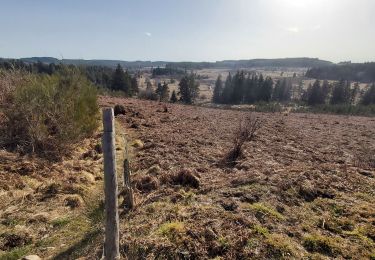
belle balade pas très difficile, beaux panoramas mais il faut aimer les forêts de Douglas. un peu trop de goudron à mon goût ce qui justifie **