![](/images/other/stat-length.png)
![Tocht Stappen Lentillères - Crêtes et hameaux de Lentillières - Photo](https://media.geolcdn.com/t/1900/400/ext.pjpeg?maxdim=2&url=https%3A%2F%2Fstatic1.geolcdn.com%2Fsiteimages%2Fupload%2Ffiles%2F1553511878bg_sport_marche.png)
Crêtes et hameaux de Lentillières
nfranche
Gebruiker
![Lengte](/images/other/stat-length.png)
Lengte
11,3 km
![Max. hoogte](https://static1.geolcdn.com/siteimages/upload/files/1508320355ic_sort_altitude_max_24dp.png)
Max. hoogte
765 m
![Positief hoogteverschil](https://static1.geolcdn.com/siteimages/upload/files/1508320355ic_sort_den_pos_24dp.png)
Positief hoogteverschil
485 m
![Km-Effort](/images/other/stat-length.png)
Km-Effort
17,8 km
![Min. hoogte](https://static1.geolcdn.com/siteimages/upload/files/1508320355ic_sort_altitude_min_24dp.png)
Min. hoogte
442 m
![Negatief hoogteverschil](https://static1.geolcdn.com/siteimages/upload/files/1508320355ic_sort_den_neg_24dp.png)
Negatief hoogteverschil
484 m
![Boucle](https://static1.geolcdn.com/siteimages/upload/files/16400158638029165_repeat_loop_refresh_sync_direction_icon.png)
Boucle
Ja
Datum van aanmaak :
2019-05-06 17:37:29.976
Laatste wijziging :
2019-05-06 17:37:29.976
![Stappen](https://static1.geolcdn.com/sitytour/trail-icons/101.png)
3h40
Moeilijkheid : Medium
![Scan deze QR-code om de tocht te openen in de SityTrail-applicatie](https://capi.geolives.com/qq0zvz2zws4bq2lad0pu/sitytour/trails/1122385/qr.png?size=200)
Gratisgps-wandelapplicatie
Over ons
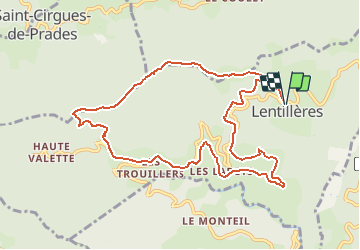
Tocht Stappen van 11,3 km beschikbaar op Auvergne-Rhône-Alpes, Ardèche, Lentillères. Deze tocht wordt voorgesteld door nfranche.
Beschrijving
Rando qui nous fait monter sur une crête d'où l'on découvre un panorama exceptionnel sur le plateau ardéchois, le bassin d'Aubenas et le Vercors.
POI's
Plaatsbepaling
Land:
France
Regio :
Auvergne-Rhône-Alpes
Departement/Provincie :
Ardèche
Gemeente :
Lentillères
Locatie:
Unknown
Vertrek:(Dec)
Vertrek:(UTM)
604191 ; 4940918 (31T) N.
Opmerkingen
Wandeltochten in de omgeving
![Tocht Stappen Jaujac - Jaujac Le Ventapet 14km - Photo](https://media.geolcdn.com/t/375/260/6a0eb2eb-cf2c-4f85-a155-e7f0aba82db8.jpg&format=jpg&maxdim=2)
![Stappen Stappen](https://static1.geolcdn.com/sitytour/trail-icons/101.png)
Jaujac Le Ventapet 14km
Stappen
Zeer moeilijk
(1)
Jaujac,
Auvergne-Rhône-Alpes,
Ardèche,
France
![](/images/other/stat-length.png)
13,6 km | 23 km-effort
5h 18min
![](https://static1.geolcdn.com/siteimages/upload/files/16400158638029165_repeat_loop_refresh_sync_direction_icon.png)
Ja
![Tocht Stappen Lentillères - Lentillières_les cretes_les Hameaux-13-02-17 - Photo](https://media.geolcdn.com/t/375/260/b26fd82a-80a8-4147-8d0f-0d41ac6326b3.jpg&format=jpg&maxdim=2)
![Stappen Stappen](https://static1.geolcdn.com/sitytour/trail-icons/101.png)
Lentillières_les cretes_les Hameaux-13-02-17
Stappen
Heel gemakkelijk
(1)
Lentillères,
Auvergne-Rhône-Alpes,
Ardèche,
France
![](/images/other/stat-length.png)
12,2 km | 18,7 km-effort
3h 58min
![](https://static1.geolcdn.com/siteimages/upload/files/16400158638029165_repeat_loop_refresh_sync_direction_icon.png)
Ja
![Tocht Stappen Fabras - Fabras - Photo](https://media.geolcdn.com/t/375/260/ext.jpg?maxdim=2&url=https%3A%2F%2Fstatic1.geolcdn.com%2Fsiteimages%2Fupload%2Ffiles%2F1553511878bg_sport_marche.png)
![Stappen Stappen](https://static1.geolcdn.com/sitytour/trail-icons/101.png)
Fabras
Stappen
Medium
(1)
Fabras,
Auvergne-Rhône-Alpes,
Ardèche,
France
![](/images/other/stat-length.png)
6,4 km | 9,7 km-effort
1h 49min
![](https://static1.geolcdn.com/siteimages/upload/files/16400158638029165_repeat_loop_refresh_sync_direction_icon.png)
Neen
![Tocht Stappen Jaujac - 07 jaujac rocher de l aigle - Photo](https://media.geolcdn.com/t/375/260/1a765c03-1770-4ba1-9c9c-9314823e934b.jpg&format=jpg&maxdim=2)
![Stappen Stappen](https://static1.geolcdn.com/sitytour/trail-icons/101.png)
07 jaujac rocher de l aigle
Stappen
Gemakkelijk
(1)
Jaujac,
Auvergne-Rhône-Alpes,
Ardèche,
France
![](/images/other/stat-length.png)
11,2 km | 19,7 km-effort
6h 23min
![](https://static1.geolcdn.com/siteimages/upload/files/16400158638029165_repeat_loop_refresh_sync_direction_icon.png)
Ja
![Stappen Stappen](https://static1.geolcdn.com/sitytour/trail-icons/101.png)
2024-09-25_21h25m23_Ailhon 9km
Stappen
Medium
Ailhon,
Auvergne-Rhône-Alpes,
Ardèche,
France
![](/images/other/stat-length.png)
8,3 km | 11,7 km-effort
2h 39min
![](https://static1.geolcdn.com/siteimages/upload/files/16400158638029165_repeat_loop_refresh_sync_direction_icon.png)
Ja
![Tocht Stappen Jaujac - ARDECHE, JAUJAC. .PONT DE L ECHELLE O - Photo](https://media.geolcdn.com/t/375/260/306eb66a-9a51-42c8-b3b4-a2c469fe7bd7.jpg&format=jpg&maxdim=2)
![Stappen Stappen](https://static1.geolcdn.com/sitytour/trail-icons/101.png)
ARDECHE, JAUJAC. .PONT DE L ECHELLE O
Stappen
Medium
Jaujac,
Auvergne-Rhône-Alpes,
Ardèche,
France
![](/images/other/stat-length.png)
5,1 km | 8,3 km-effort
2h 33min
![](https://static1.geolcdn.com/siteimages/upload/files/16400158638029165_repeat_loop_refresh_sync_direction_icon.png)
Neen
![Tocht Stappen Jaujac - 07_jaujac_Orgues_9km360m - Photo](https://media.geolcdn.com/t/375/260/944ad327-537f-4f2c-8001-5010f7cb1f7d.jpg&format=jpg&maxdim=2)
![Stappen Stappen](https://static1.geolcdn.com/sitytour/trail-icons/101.png)
07_jaujac_Orgues_9km360m
Stappen
Medium
Jaujac,
Auvergne-Rhône-Alpes,
Ardèche,
France
![](/images/other/stat-length.png)
9,1 km | 13,8 km-effort
3h 7min
![](https://static1.geolcdn.com/siteimages/upload/files/16400158638029165_repeat_loop_refresh_sync_direction_icon.png)
Ja
![Tocht Stappen Fabras - Fabras Jaujac les orgues basaltiques - Photo](https://media.geolcdn.com/t/375/260/427a2c6b-ef91-4b91-a4d9-6a96b4534007.jpg&format=jpg&maxdim=2)
![Stappen Stappen](https://static1.geolcdn.com/sitytour/trail-icons/101.png)
Fabras Jaujac les orgues basaltiques
Stappen
Zeer moeilijk
Fabras,
Auvergne-Rhône-Alpes,
Ardèche,
France
![](/images/other/stat-length.png)
14,9 km | 22 km-effort
5h 17min
![](https://static1.geolcdn.com/siteimages/upload/files/16400158638029165_repeat_loop_refresh_sync_direction_icon.png)
Ja
![Stappen Stappen](https://static1.geolcdn.com/sitytour/trail-icons/101.png)
2023-03-20_16h29m52_Chazeaux 9km.GPX.xml
Stappen
Moeilijk
Chazeaux,
Auvergne-Rhône-Alpes,
Ardèche,
France
![](/images/other/stat-length.png)
8,3 km | 13,4 km-effort
3h 0min
![](https://static1.geolcdn.com/siteimages/upload/files/16400158638029165_repeat_loop_refresh_sync_direction_icon.png)
Ja