![](/images/other/stat-length.png)
![Tocht Stappen Amiens - Circuit Sainte-Aragone - Amiens - Photo](https://media.geolcdn.com/t/1900/400/ext.pjpeg?maxdim=2&url=https%3A%2F%2Fservices.sitytrail.com%2FGeolivesWS%2FDownloadMedia.ashx%3FTrailID%3D112098%26Media%3D9893_6.jpg)
Circuit Sainte-Aragone - Amiens
tracegps
Gebruiker
![Lengte](/images/other/stat-length.png)
Lengte
12,1 km
![Max. hoogte](https://static1.geolcdn.com/siteimages/upload/files/1508320355ic_sort_altitude_max_24dp.png)
Max. hoogte
26 m
![Positief hoogteverschil](https://static1.geolcdn.com/siteimages/upload/files/1508320355ic_sort_den_pos_24dp.png)
Positief hoogteverschil
76 m
![Km-Effort](/images/other/stat-length.png)
Km-Effort
13,1 km
![Min. hoogte](https://static1.geolcdn.com/siteimages/upload/files/1508320355ic_sort_altitude_min_24dp.png)
Min. hoogte
9 m
![Negatief hoogteverschil](https://static1.geolcdn.com/siteimages/upload/files/1508320355ic_sort_den_neg_24dp.png)
Negatief hoogteverschil
76 m
![Boucle](https://static1.geolcdn.com/siteimages/upload/files/16400158638029165_repeat_loop_refresh_sync_direction_icon.png)
Boucle
Ja
Datum van aanmaak :
2014-12-10 00:00:00.0
Laatste wijziging :
2014-12-10 00:00:00.0
![Stappen](https://static1.geolcdn.com/sitytour/trail-icons/101.png)
3h00
Moeilijkheid : Medium
![Scan deze QR-code om de tocht te openen in de SityTrail-applicatie](https://capi.geolives.com/qq0zvz2zws4bq2lad0pu/sitytour/trails/112098/qr.png?size=200)
Gratisgps-wandelapplicatie
Over ons
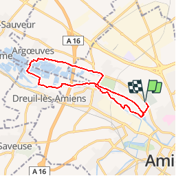
Tocht Stappen van 12,1 km beschikbaar op Hauts-de-France, Somme, Amiens. Deze tocht wordt voorgesteld door tracegps.
Beschrijving
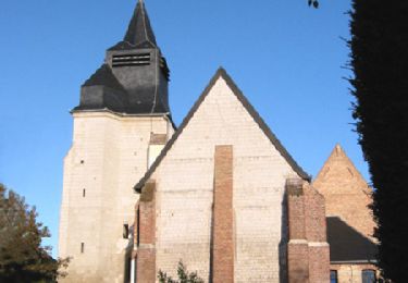
Circuit proposé par la Mairie de Camon. Départ du parking le long du Cimetière de la Madeleine à Amiens. A découvrir : Le tombeau de Jules Verne. Retrouvez cette randonnée sur le site de la mairie, rubrique « Tourisme et loisirs ».
Plaatsbepaling
Land:
France
Regio :
Hauts-de-France
Departement/Provincie :
Somme
Gemeente :
Amiens
Locatie:
Unknown
Vertrek:(Dec)
Vertrek:(UTM)
448431 ; 5529212 (31U) N.
Opmerkingen
Wandeltochten in de omgeving
![Tocht Mountainbike Amiens - Dury chisel - Photo](https://media.geolcdn.com/t/375/260/ext.jpg?maxdim=2&url=https%3A%2F%2Fservices.sitytrail.com%2FGeolivesWS%2FDownloadMedia.ashx%3FTrailID%3D837782%26Media%3D20170924172157.jpg)
![Mountainbike Mountainbike](https://static1.geolcdn.com/sitytour/trail-icons/202.png)
Dury chisel
Mountainbike
Gemakkelijk
(1)
Amiens,
Hauts-de-France,
Somme,
France
![](/images/other/stat-length.png)
21 km | 24 km-effort
1h 4min
![](https://static1.geolcdn.com/siteimages/upload/files/16400158638029165_repeat_loop_refresh_sync_direction_icon.png)
Ja
![Tocht Stappen Amiens - 2016 05 01 - Photo](https://media.geolcdn.com/t/375/260/ext.jpg?maxdim=2&url=https%3A%2F%2Fstatic1.geolcdn.com%2Fsiteimages%2Fupload%2Ffiles%2F1553511878bg_sport_marche.png)
![Stappen Stappen](https://static1.geolcdn.com/sitytour/trail-icons/101.png)
2016 05 01
Stappen
Moeilijk
(1)
Amiens,
Hauts-de-France,
Somme,
France
![](/images/other/stat-length.png)
42 km | 46 km-effort
7h 25min
![](https://static1.geolcdn.com/siteimages/upload/files/16400158638029165_repeat_loop_refresh_sync_direction_icon.png)
Ja
![Tocht Stappen Amiens - amiens - Photo](https://media.geolcdn.com/t/375/260/ext.jpg?maxdim=2&url=https%3A%2F%2Fstatic1.geolcdn.com%2Fsiteimages%2Fupload%2Ffiles%2F1553511878bg_sport_marche.png)
![Stappen Stappen](https://static1.geolcdn.com/sitytour/trail-icons/101.png)
amiens
Stappen
Gemakkelijk
(2)
Amiens,
Hauts-de-France,
Somme,
France
![](/images/other/stat-length.png)
12,7 km | 13,8 km-effort
2h 12min
![](https://static1.geolcdn.com/siteimages/upload/files/16400158638029165_repeat_loop_refresh_sync_direction_icon.png)
Neen
![Tocht Stappen Amiens - 2013-05-04 - Photo](https://media.geolcdn.com/t/375/260/ext.jpg?maxdim=2&url=https%3A%2F%2Fstatic1.geolcdn.com%2Fsiteimages%2Fupload%2Ffiles%2F1553511878bg_sport_marche.png)
![Stappen Stappen](https://static1.geolcdn.com/sitytour/trail-icons/101.png)
2013-05-04
Stappen
Medium
(1)
Amiens,
Hauts-de-France,
Somme,
France
![](/images/other/stat-length.png)
42 km | 47 km-effort
6h 45min
![](https://static1.geolcdn.com/siteimages/upload/files/16400158638029165_repeat_loop_refresh_sync_direction_icon.png)
Ja
![Tocht Stappen Amiens - petite balade nocturne a Amiens - Photo](https://media.geolcdn.com/t/375/260/3d5355c2-b037-45bc-b47b-3e4ae4a7773b.jpg&format=jpg&maxdim=2)
![Stappen Stappen](https://static1.geolcdn.com/sitytour/trail-icons/101.png)
petite balade nocturne a Amiens
Stappen
Gemakkelijk
Amiens,
Hauts-de-France,
Somme,
France
![](/images/other/stat-length.png)
5 km | 5,6 km-effort
1h 23min
![](https://static1.geolcdn.com/siteimages/upload/files/16400158638029165_repeat_loop_refresh_sync_direction_icon.png)
Ja
![Tocht Stappen Amiens - amiens camon amiens par les hortillonnages - Photo](https://media.geolcdn.com/t/375/260/f3a798f8-f752-4aef-a4d7-c774ac9735b0.jpg&format=jpg&maxdim=2)
![Stappen Stappen](https://static1.geolcdn.com/sitytour/trail-icons/101.png)
amiens camon amiens par les hortillonnages
Stappen
Heel gemakkelijk
Amiens,
Hauts-de-France,
Somme,
France
![](/images/other/stat-length.png)
8,4 km | 9,2 km-effort
2h 12min
![](https://static1.geolcdn.com/siteimages/upload/files/16400158638029165_repeat_loop_refresh_sync_direction_icon.png)
Ja
![Tocht Elektrische fiets Amiens - Amiens Gouy les groseilliers - Photo](https://media.geolcdn.com/t/375/260/60b58993-346a-49c2-974e-a41c756ae7ca.jpg&format=jpg&maxdim=2)
![Elektrische fiets Elektrische fiets](https://static1.geolcdn.com/sitytour/trail-icons/205.png)
Amiens Gouy les groseilliers
Elektrische fiets
Moeilijk
Amiens,
Hauts-de-France,
Somme,
France
![](/images/other/stat-length.png)
48 km | 0 m-effort
3h 2min
![](https://static1.geolcdn.com/siteimages/upload/files/16400158638029165_repeat_loop_refresh_sync_direction_icon.png)
Neen
![Tocht Stappen Amiens - Circuit de la Canardière - Amiens - Photo](https://media.geolcdn.com/t/375/260/ext.jpg?maxdim=2&url=https%3A%2F%2Fservices.sitytrail.com%2FGeolivesWS%2FDownloadMedia.ashx%3FTrailID%3D112087%26Media%3D9859_6.jpg)
![Stappen Stappen](https://static1.geolcdn.com/sitytour/trail-icons/101.png)
Circuit de la Canardière - Amiens
Stappen
Moeilijk
Amiens,
Hauts-de-France,
Somme,
France
![](/images/other/stat-length.png)
14,2 km | 15,2 km-effort
3h 30min
![](https://static1.geolcdn.com/siteimages/upload/files/16400158638029165_repeat_loop_refresh_sync_direction_icon.png)
Ja
![Tocht Stappen Amiens - Sur les pas de Jules Verne - Amiens - Photo](https://media.geolcdn.com/t/375/260/ext.jpg?maxdim=2&url=https%3A%2F%2Fservices.sitytrail.com%2FGeolivesWS%2FDownloadMedia.ashx%3FTrailID%3D105900%26Media%3D9898_6.jpg)
![Stappen Stappen](https://static1.geolcdn.com/sitytour/trail-icons/101.png)
Sur les pas de Jules Verne - Amiens
Stappen
Gemakkelijk
Amiens,
Hauts-de-France,
Somme,
France
![](/images/other/stat-length.png)
5,7 km | 6,3 km-effort
1h 30min
![](https://static1.geolcdn.com/siteimages/upload/files/16400158638029165_repeat_loop_refresh_sync_direction_icon.png)
Ja