![](/images/other/stat-length.png)
![Tocht Fiets Aniane - Le Coeur d'Hérault à vélo n°2 - La route médiévale - Aniane - Photo](https://media.geolcdn.com/t/1900/400/ext.pjpeg?maxdim=2&url=https%3A%2F%2Fservices.sitytrail.com%2FGeolivesWS%2FDownloadMedia.ashx%3FTrailID%3D112031%26Media%3D9517_2.jpg)
Le Coeur d'Hérault à vélo n°2 - La route médiévale - Aniane
tracegps
Gebruiker
![Lengte](/images/other/stat-length.png)
Lengte
34 km
![Max. hoogte](https://static1.geolcdn.com/siteimages/upload/files/1508320355ic_sort_altitude_max_24dp.png)
Max. hoogte
264 m
![Positief hoogteverschil](https://static1.geolcdn.com/siteimages/upload/files/1508320355ic_sort_den_pos_24dp.png)
Positief hoogteverschil
497 m
![Km-Effort](/images/other/stat-length.png)
Km-Effort
41 km
![Min. hoogte](https://static1.geolcdn.com/siteimages/upload/files/1508320355ic_sort_altitude_min_24dp.png)
Min. hoogte
58 m
![Negatief hoogteverschil](https://static1.geolcdn.com/siteimages/upload/files/1508320355ic_sort_den_neg_24dp.png)
Negatief hoogteverschil
496 m
![Boucle](https://static1.geolcdn.com/siteimages/upload/files/16400158638029165_repeat_loop_refresh_sync_direction_icon.png)
Boucle
Ja
Datum van aanmaak :
2014-12-10 00:00:00.0
Laatste wijziging :
2014-12-10 00:00:00.0
![Fiets](https://static1.geolcdn.com/sitytour/trail-icons/200.png)
2h45
Moeilijkheid : Medium
![Scan deze QR-code om de tocht te openen in de SityTrail-applicatie](https://capi.geolives.com/qq0zvz2zws4bq2lad0pu/sitytour/trails/112031/qr.png?size=200)
Gratisgps-wandelapplicatie
Over ons
Tocht Fiets van 34 km beschikbaar op Occitanië, Hérault, Aniane. Deze tocht wordt voorgesteld door tracegps.
Beschrijving
Cet itinéraire "nature" vous conduira à la découverte des collines de la vallée de l'Hérault, à travers de vastes espaces boisés. Les villages traversés sont anciens et portent les traces d'une occupation médiévale, identifiable à travers de nombreux éléments de patrimoine bâti.
Plaatsbepaling
Land:
France
Regio :
Occitanië
Departement/Provincie :
Hérault
Gemeente :
Aniane
Locatie:
Unknown
Vertrek:(Dec)
Vertrek:(UTM)
545291 ; 4839114 (31T) N.
Opmerkingen
Wandeltochten in de omgeving
![Tocht Stappen Aniane - Aniane ruisseau des Corbières - Photo](https://media.geolcdn.com/t/375/260/ext.jpg?maxdim=2&url=https%3A%2F%2Fservices.sitytrail.com%2FGeolivesWS%2FDownloadMedia.ashx%3FTrailID%3D371677%26Media%3D20141221154017.jpg)
![Stappen Stappen](https://static1.geolcdn.com/sitytour/trail-icons/101.png)
Aniane ruisseau des Corbières
Stappen
Gemakkelijk
(3)
Aniane,
Occitanië,
Hérault,
France
![](/images/other/stat-length.png)
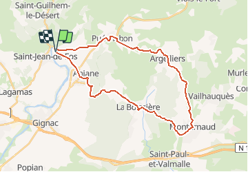
9,5 km | 12 km-effort
2h 34min
![](https://static1.geolcdn.com/siteimages/upload/files/16400158638029165_repeat_loop_refresh_sync_direction_icon.png)
Ja
![Tocht Stappen Saint-Jean-de-Fos - St Jean de fos Les Plos - Photo](https://media.geolcdn.com/t/375/260/ext.jpg?maxdim=2&url=https%3A%2F%2Fservices.sitytrail.com%2FGeolivesWS%2FDownloadMedia.ashx%3FTrailID%3D358380%26Media%3D20141024141711.jpg)
![Stappen Stappen](https://static1.geolcdn.com/sitytour/trail-icons/101.png)
St Jean de fos Les Plos
Stappen
Gemakkelijk
(3)
Saint-Jean-de-Fos,
Occitanië,
Hérault,
France
![](/images/other/stat-length.png)
11 km | 15,2 km-effort
3h 5min
![](https://static1.geolcdn.com/siteimages/upload/files/16400158638029165_repeat_loop_refresh_sync_direction_icon.png)
Ja
![Tocht Stappen Montpeyroux - château de castelas - Photo](https://media.geolcdn.com/t/375/260/ext.jpg?maxdim=2&url=https%3A%2F%2Fservices.sitytrail.com%2FGeolivesWS%2FDownloadMedia.ashx%3FTrailID%3D221327%26Media%3D20130914120534.jpg)
![Stappen Stappen](https://static1.geolcdn.com/sitytour/trail-icons/101.png)
château de castelas
Stappen
Gemakkelijk
(3)
Montpeyroux,
Occitanië,
Hérault,
France
![](/images/other/stat-length.png)
10,3 km | 15,1 km-effort
3h 12min
![](https://static1.geolcdn.com/siteimages/upload/files/16400158638029165_repeat_loop_refresh_sync_direction_icon.png)
Ja
![Tocht Stappen Saint-Guilhem-le-Désert - Herault - St-Guilhem-le-Desert le Roc de la Vigne depuis le barrage 12km 609m - Photo](https://media.geolcdn.com/t/375/260/ext.jpg?maxdim=2&url=https%3A%2F%2Fstatic1.geolcdn.com%2Fsiteimages%2Fupload%2Ffiles%2F1553511878bg_sport_marche.png)
![Stappen Stappen](https://static1.geolcdn.com/sitytour/trail-icons/101.png)
Herault - St-Guilhem-le-Desert le Roc de la Vigne depuis le barrage 12km 609m
Stappen
Medium
(1)
Saint-Guilhem-le-Désert,
Occitanië,
Hérault,
France
![](/images/other/stat-length.png)
12,1 km | 21 km-effort
4h 17min
![](https://static1.geolcdn.com/siteimages/upload/files/16400158638029165_repeat_loop_refresh_sync_direction_icon.png)
Ja
![Tocht Stappen Saint-Jean-de-Fos - St Jean de Fos et le Max Nègre - Photo](https://media.geolcdn.com/t/375/260/ext.jpg?maxdim=2&url=https%3A%2F%2Fservices.sitytrail.com%2FGeolivesWS%2FDownloadMedia.ashx%3FTrailID%3D230380%26Media%3Dfix__20131101122921.jpg)
![Stappen Stappen](https://static1.geolcdn.com/sitytour/trail-icons/101.png)
St Jean de Fos et le Max Nègre
Stappen
Medium
Saint-Jean-de-Fos,
Occitanië,
Hérault,
France
![](/images/other/stat-length.png)
19,1 km | 27 km-effort
5h 42min
![](https://static1.geolcdn.com/siteimages/upload/files/16400158638029165_repeat_loop_refresh_sync_direction_icon.png)
Ja
![Tocht Stappen Puéchabon - Causse Puechabon - Photo](https://media.geolcdn.com/t/375/260/ext.jpg?maxdim=2&url=https%3A%2F%2Fstatic1.geolcdn.com%2Fsiteimages%2Fupload%2Ffiles%2F1553511878bg_sport_marche.png)
![Stappen Stappen](https://static1.geolcdn.com/sitytour/trail-icons/101.png)
Causse Puechabon
Stappen
Heel gemakkelijk
(1)
Puéchabon,
Occitanië,
Hérault,
France
![](/images/other/stat-length.png)
12,8 km | 15,9 km-effort
Onbekend
![](https://static1.geolcdn.com/siteimages/upload/files/16400158638029165_repeat_loop_refresh_sync_direction_icon.png)
Ja
![Tocht Stappen Saint-Guilhem-le-Désert - St Guilhem Le Désert - Mas Aubert - Photo](https://media.geolcdn.com/t/375/260/ext.jpg?maxdim=2&url=https%3A%2F%2Fstatic1.geolcdn.com%2Fsiteimages%2Fupload%2Ffiles%2F1553511878bg_sport_marche.png)
![Stappen Stappen](https://static1.geolcdn.com/sitytour/trail-icons/101.png)
St Guilhem Le Désert - Mas Aubert
Stappen
Moeilijk
(1)
Saint-Guilhem-le-Désert,
Occitanië,
Hérault,
France
![](/images/other/stat-length.png)
19,7 km | 30 km-effort
6h 30min
![](https://static1.geolcdn.com/siteimages/upload/files/16400158638029165_repeat_loop_refresh_sync_direction_icon.png)
Ja
![Tocht Stappen Aniane - Plateau Montcamès - Photo](https://media.geolcdn.com/t/375/260/b02f8392-ab26-453d-ab12-fab47a60d22f.jpg&format=jpg&maxdim=2)
![Stappen Stappen](https://static1.geolcdn.com/sitytour/trail-icons/101.png)
Plateau Montcamès
Stappen
Zeer moeilijk
Aniane,
Occitanië,
Hérault,
France
![](/images/other/stat-length.png)
17,7 km | 23 km-effort
6h 21min
![](https://static1.geolcdn.com/siteimages/upload/files/16400158638029165_repeat_loop_refresh_sync_direction_icon.png)
Ja
![Tocht Stappen Montpeyroux - Le bary Arboras le Castelas - Photo](https://media.geolcdn.com/t/375/260/be1b8dbb-902e-4f34-ac2c-776d8a42a8d8.jpg&format=jpg&maxdim=2)
![Stappen Stappen](https://static1.geolcdn.com/sitytour/trail-icons/101.png)
Le bary Arboras le Castelas
Stappen
Gemakkelijk
Montpeyroux,
Occitanië,
Hérault,
France
![](/images/other/stat-length.png)
11,8 km | 17,1 km-effort
5h 7min
![](https://static1.geolcdn.com/siteimages/upload/files/16400158638029165_repeat_loop_refresh_sync_direction_icon.png)
Ja