![](/images/other/stat-length.png)
![Tocht Fiets Soks - Circuit de l'Houtland intérieur - Socx - Photo](https://media.geolcdn.com/t/1900/400/ext.pjpeg?maxdim=2&url=https%3A%2F%2Fservices.sitytrail.com%2FGeolivesWS%2FDownloadMedia.ashx%3FTrailID%3D111980%26Media%3D9286_6.jpg)
Circuit de l'Houtland intérieur - Socx
tracegps
Gebruiker
![Lengte](/images/other/stat-length.png)
Lengte
32 km
![Max. hoogte](https://static1.geolcdn.com/siteimages/upload/files/1508320355ic_sort_altitude_max_24dp.png)
Max. hoogte
38 m
![Positief hoogteverschil](https://static1.geolcdn.com/siteimages/upload/files/1508320355ic_sort_den_pos_24dp.png)
Positief hoogteverschil
153 m
![Km-Effort](/images/other/stat-length.png)
Km-Effort
34 km
![Min. hoogte](https://static1.geolcdn.com/siteimages/upload/files/1508320355ic_sort_altitude_min_24dp.png)
Min. hoogte
-3 m
![Negatief hoogteverschil](https://static1.geolcdn.com/siteimages/upload/files/1508320355ic_sort_den_neg_24dp.png)
Negatief hoogteverschil
152 m
![Boucle](https://static1.geolcdn.com/siteimages/upload/files/16400158638029165_repeat_loop_refresh_sync_direction_icon.png)
Boucle
Ja
Datum van aanmaak :
2014-12-10 00:00:00.0
Laatste wijziging :
2014-12-10 00:00:00.0
![Fiets](https://static1.geolcdn.com/sitytour/trail-icons/200.png)
1h45
Moeilijkheid : Medium
![Scan deze QR-code om de tocht te openen in de SityTrail-applicatie](https://capi.geolives.com/qq0zvz2zws4bq2lad0pu/sitytour/trails/111980/qr.png?size=200)
Gratisgps-wandelapplicatie
Over ons
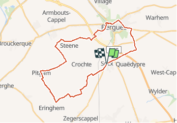
Tocht Fiets van 32 km beschikbaar op Hauts-de-France, Noorderdepartement, Soks. Deze tocht wordt voorgesteld door tracegps.
Beschrijving
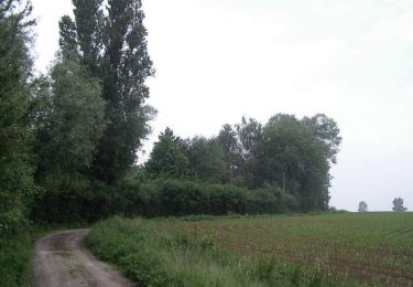
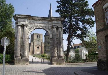
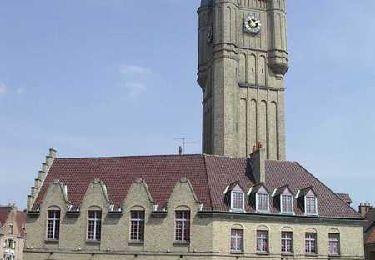
Circuit proposé par le comité départemental du Nord. Départ du parking prés de l’église de Socx. Le circuit vous emmènera par de petites routes à travers l’Houtland jusqu'à Bergues. Ce circuit a été numérisé par les randonneurs du CODEPEM.
Plaatsbepaling
Land:
France
Regio :
Hauts-de-France
Departement/Provincie :
Noorderdepartement
Gemeente :
Soks
Locatie:
Unknown
Vertrek:(Dec)
Vertrek:(UTM)
459413 ; 5642807 (31U) N.
Opmerkingen
Wandeltochten in de omgeving
![Tocht Stappen Sint-Winoksbergen - BERGUES - Photo](https://media.geolcdn.com/t/375/260/a016e08c-a0f7-4b3f-bc9c-ca4831f65d2f.jpg&format=jpg&maxdim=2)
![Stappen Stappen](https://static1.geolcdn.com/sitytour/trail-icons/101.png)
BERGUES
Stappen
Medium
Sint-Winoksbergen,
Hauts-de-France,
Noorderdepartement,
France
![](/images/other/stat-length.png)
7,4 km | 8 km-effort
3h 39min
![](https://static1.geolcdn.com/siteimages/upload/files/16400158638029165_repeat_loop_refresh_sync_direction_icon.png)
Ja
![Tocht Stappen Sint-Winoksbergen - sortie Bergues 21 mai 2017 - Photo](https://media.geolcdn.com/t/375/260/ext.jpg?maxdim=2&url=https%3A%2F%2Fservices.sitytrail.com%2FGeolivesWS%2FDownloadMedia.ashx%3FTrailID%3D757057%26Media%3D20170521094707.jpg)
![Stappen Stappen](https://static1.geolcdn.com/sitytour/trail-icons/101.png)
sortie Bergues 21 mai 2017
Stappen
Heel gemakkelijk
Sint-Winoksbergen,
Hauts-de-France,
Noorderdepartement,
France
![](/images/other/stat-length.png)
18,1 km | 19,4 km-effort
4h 23min
![](https://static1.geolcdn.com/siteimages/upload/files/16400158638029165_repeat_loop_refresh_sync_direction_icon.png)
Ja
![Tocht Stappen Sint-Winoksbergen - Bergues : Nature et Histoire - Photo](https://media.geolcdn.com/t/375/260/ext.jpg?maxdim=2&url=https%3A%2F%2Fservices.sitytrail.com%2FGeolivesWS%2FDownloadMedia.ashx%3FTrailID%3D202868%26Media%3Df4975fa8-5dba-4ae9-ba49-5aba72df299f.jpg)
![Stappen Stappen](https://static1.geolcdn.com/sitytour/trail-icons/101.png)
Bergues : Nature et Histoire
Stappen
Heel gemakkelijk
(1)
Sint-Winoksbergen,
Hauts-de-France,
Noorderdepartement,
France
![](/images/other/stat-length.png)
5,2 km | 5,7 km-effort
Onbekend
![](https://static1.geolcdn.com/siteimages/upload/files/16400158638029165_repeat_loop_refresh_sync_direction_icon.png)
Ja
![Tocht Stappen Wilder - Circuit GPS du Château de la Briarde - Wylder - Photo](https://media.geolcdn.com/t/375/260/ext.jpg?maxdim=2&url=https%3A%2F%2Fservices.sitytrail.com%2FGeolivesWS%2FDownloadMedia.ashx%3FTrailID%3D109199%26Media%3D3269_6.jpg)
![Stappen Stappen](https://static1.geolcdn.com/sitytour/trail-icons/101.png)
Circuit GPS du Château de la Briarde - Wylder
Stappen
Medium
Wilder,
Hauts-de-France,
Noorderdepartement,
France
![](/images/other/stat-length.png)
11,2 km | 11,9 km-effort
2h 49min
![](https://static1.geolcdn.com/siteimages/upload/files/16400158638029165_repeat_loop_refresh_sync_direction_icon.png)
Ja
![Tocht Stappen Sint-Winoksbergen - Bergues Nature et histoire - Photo](https://media.geolcdn.com/t/375/260/ext.jpg?maxdim=2&url=https%3A%2F%2Fservices.sitytrail.com%2FGeolivesWS%2FDownloadMedia.ashx%3FTrailID%3D109056%26Media%3D3071_6.jpg)
![Stappen Stappen](https://static1.geolcdn.com/sitytour/trail-icons/101.png)
Bergues Nature et histoire
Stappen
Gemakkelijk
Sint-Winoksbergen,
Hauts-de-France,
Noorderdepartement,
France
![](/images/other/stat-length.png)
4,9 km | 5,4 km-effort
1h 15min
![](https://static1.geolcdn.com/siteimages/upload/files/16400158638029165_repeat_loop_refresh_sync_direction_icon.png)
Ja
![Tocht Stappen Sint-Winoksbergen - Bienvenue chez les Ch'tis ou Bergues une balade GPS de charme - Photo](https://media.geolcdn.com/t/375/260/ext.jpg?maxdim=2&url=https%3A%2F%2Fservices.sitytrail.com%2FGeolivesWS%2FDownloadMedia.ashx%3FTrailID%3D109055%26Media%3D3070_6.jpg)
![Stappen Stappen](https://static1.geolcdn.com/sitytour/trail-icons/101.png)
Bienvenue chez les Ch'tis ou Bergues une balade GPS de charme
Stappen
Gemakkelijk
Sint-Winoksbergen,
Hauts-de-France,
Noorderdepartement,
France
![](/images/other/stat-length.png)
4,1 km | 4,5 km-effort
1h 0min
![](https://static1.geolcdn.com/siteimages/upload/files/16400158638029165_repeat_loop_refresh_sync_direction_icon.png)
Ja
![Tocht Stappen Warrem - Warhem - Village Patrimoine - Photo](https://media.geolcdn.com/t/375/260/ext.jpg?maxdim=2&url=https%3A%2F%2Fservices.sitytrail.com%2FGeolivesWS%2FDownloadMedia.ashx%3FTrailID%3D105867%26Media%3D9845_6.jpg)
![Stappen Stappen](https://static1.geolcdn.com/sitytour/trail-icons/101.png)
Warhem - Village Patrimoine
Stappen
Gemakkelijk
Warrem,
Hauts-de-France,
Noorderdepartement,
France
![](/images/other/stat-length.png)
1,5 km | 1,6 km-effort
25min
![](https://static1.geolcdn.com/siteimages/upload/files/16400158638029165_repeat_loop_refresh_sync_direction_icon.png)
Ja
![Tocht Stappen Sint-Winoksbergen - t273355040_autour de et a bergues - Photo](https://media.geolcdn.com/t/375/260/ext.jpg?maxdim=2&url=https%3A%2F%2Fstatic1.geolcdn.com%2Fsiteimages%2Fupload%2Ffiles%2F1553511878bg_sport_marche.png)
![Stappen Stappen](https://static1.geolcdn.com/sitytour/trail-icons/101.png)
t273355040_autour de et a bergues
Stappen
Heel gemakkelijk
Sint-Winoksbergen,
Hauts-de-France,
Noorderdepartement,
France
![](/images/other/stat-length.png)
18,1 km | 19,4 km-effort
4h 24min
![](https://static1.geolcdn.com/siteimages/upload/files/16400158638029165_repeat_loop_refresh_sync_direction_icon.png)
Ja
![Elektrische fiets Elektrische fiets](https://static1.geolcdn.com/sitytour/trail-icons/205.png)
Les hauts des Flandres - Les villages classés
Elektrische fiets
Heel gemakkelijk
Bieren,
Hauts-de-France,
Noorderdepartement,
France
![](/images/other/stat-length.png)
60 km | 63 km-effort
Onbekend
![](https://static1.geolcdn.com/siteimages/upload/files/16400158638029165_repeat_loop_refresh_sync_direction_icon.png)
Ja