![](/images/other/stat-length.png)
![Tocht Stappen Guipry-Messac - L'étang et le bois de Baron - Messac Guipry - Photo](https://media.geolcdn.com/t/1900/400/ext.pjpeg?maxdim=2&url=https%3A%2F%2Fservices.sitytrail.com%2FGeolivesWS%2FDownloadMedia.ashx%3FTrailID%3D111683%26Media%3D7933_2.jpg)
L'étang et le bois de Baron - Messac Guipry
tracegps
Gebruiker
![Lengte](/images/other/stat-length.png)
Lengte
8,5 km
![Max. hoogte](https://static1.geolcdn.com/siteimages/upload/files/1508320355ic_sort_altitude_max_24dp.png)
Max. hoogte
102 m
![Positief hoogteverschil](https://static1.geolcdn.com/siteimages/upload/files/1508320355ic_sort_den_pos_24dp.png)
Positief hoogteverschil
181 m
![Km-Effort](/images/other/stat-length.png)
Km-Effort
10,9 km
![Min. hoogte](https://static1.geolcdn.com/siteimages/upload/files/1508320355ic_sort_altitude_min_24dp.png)
Min. hoogte
8 m
![Negatief hoogteverschil](https://static1.geolcdn.com/siteimages/upload/files/1508320355ic_sort_den_neg_24dp.png)
Negatief hoogteverschil
179 m
![Boucle](https://static1.geolcdn.com/siteimages/upload/files/16400158638029165_repeat_loop_refresh_sync_direction_icon.png)
Boucle
Ja
Datum van aanmaak :
2014-12-10 00:00:00.0
Laatste wijziging :
2014-12-10 00:00:00.0
![Stappen](https://static1.geolcdn.com/sitytour/trail-icons/101.png)
2h10
Moeilijkheid : Medium
![Scan deze QR-code om de tocht te openen in de SityTrail-applicatie](https://capi.geolives.com/qq0zvz2zws4bq2lad0pu/sitytour/trails/111683/qr.png?size=200)
Gratisgps-wandelapplicatie
Over ons
Tocht Stappen van 8,5 km beschikbaar op Bretagne, Ille-et-Vilaine, Guipry-Messac. Deze tocht wordt voorgesteld door tracegps.
Beschrijving
Circuit proposé par la maison du tourisme du Pays de Redon. Départ de l’auberge de baron. Retrouvez le circuit sur le site du Pays de Redon.
Plaatsbepaling
Land:
France
Regio :
Bretagne
Departement/Provincie :
Ille-et-Vilaine
Gemeente :
Guipry-Messac
Locatie:
Guipry
Vertrek:(Dec)
Vertrek:(UTM)
585885 ; 5292703 (30T) N.
Opmerkingen
Wandeltochten in de omgeving
![Tocht Paard Langon - Vallées, landes et mégalithes entre Langon et Cournon - Photo](https://media.geolcdn.com/t/375/260/ext.jpg?maxdim=2&url=https%3A%2F%2Fservices.sitytrail.com%2FGeolivesWS%2FDownloadMedia.ashx%3FTrailID%3D317577%26Media%3D16836_5.jpg)
![Paard Paard](https://static1.geolcdn.com/sitytour/trail-icons/300.png)
Vallées, landes et mégalithes entre Langon et Cournon
Paard
Moeilijk
Langon,
Bretagne,
Ille-et-Vilaine,
France
![](/images/other/stat-length.png)
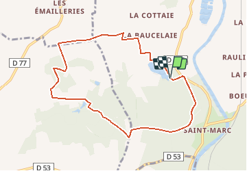
33 km | 39 km-effort
3h 0min
![](https://static1.geolcdn.com/siteimages/upload/files/16400158638029165_repeat_loop_refresh_sync_direction_icon.png)
Neen
![Tocht Paard Guipry-Messac - Chevauchée au coeur de la vallée de la Vilaine - Guipry - Photo](https://media.geolcdn.com/t/375/260/ext.jpg?maxdim=2&url=https%3A%2F%2Fservices.sitytrail.com%2FGeolivesWS%2FDownloadMedia.ashx%3FTrailID%3D317252%26Media%3D16434_5.jpg)
![Paard Paard](https://static1.geolcdn.com/sitytour/trail-icons/300.png)
Chevauchée au coeur de la vallée de la Vilaine - Guipry
Paard
Moeilijk
Guipry-Messac,
Bretagne,
Ille-et-Vilaine,
France
![](/images/other/stat-length.png)
29 km | 36 km-effort
4h 0min
![](https://static1.geolcdn.com/siteimages/upload/files/16400158638029165_repeat_loop_refresh_sync_direction_icon.png)
Ja
![Tocht Stappen Langon - Circuit à l'Assaut de Corbinières - Langon - Photo](https://media.geolcdn.com/t/375/260/ext.jpg?maxdim=2&url=https%3A%2F%2Fservices.sitytrail.com%2FGeolivesWS%2FDownloadMedia.ashx%3FTrailID%3D111779%26Media%3D8286_5.jpg)
![Stappen Stappen](https://static1.geolcdn.com/sitytour/trail-icons/101.png)
Circuit à l'Assaut de Corbinières - Langon
Stappen
Moeilijk
Langon,
Bretagne,
Ille-et-Vilaine,
France
![](/images/other/stat-length.png)
15,6 km | 19,8 km-effort
4h 0min
![](https://static1.geolcdn.com/siteimages/upload/files/16400158638029165_repeat_loop_refresh_sync_direction_icon.png)
Ja
![Tocht Stappen Guipry-Messac - Rochers de Corbiniéres - Messac Guipry - Photo](https://media.geolcdn.com/t/375/260/ext.jpg?maxdim=2&url=https%3A%2F%2Fservices.sitytrail.com%2FGeolivesWS%2FDownloadMedia.ashx%3FTrailID%3D111684%26Media%3D7934_6.jpg)
![Stappen Stappen](https://static1.geolcdn.com/sitytour/trail-icons/101.png)
Rochers de Corbiniéres - Messac Guipry
Stappen
Moeilijk
Guipry-Messac,
Bretagne,
Ille-et-Vilaine,
France
![](/images/other/stat-length.png)
13,9 km | 17,2 km-effort
3h 45min
![](https://static1.geolcdn.com/siteimages/upload/files/16400158638029165_repeat_loop_refresh_sync_direction_icon.png)
Ja
![Tocht Elektrische fiets Guipry-Messac - Guipry-Messac à Redon - Photo](https://media.geolcdn.com/t/375/260/ext.jpg?maxdim=2&url=https%3A%2F%2Fstatic1.geolcdn.com%2Fsiteimages%2Fupload%2Ffiles%2F1524743154velo.jpg)
![Elektrische fiets Elektrische fiets](https://static1.geolcdn.com/sitytour/trail-icons/205.png)
Guipry-Messac à Redon
Elektrische fiets
Medium
Guipry-Messac,
Bretagne,
Ille-et-Vilaine,
France
![](/images/other/stat-length.png)
46 km | 50 km-effort
3h 33min
![](https://static1.geolcdn.com/siteimages/upload/files/16400158638029165_repeat_loop_refresh_sync_direction_icon.png)
Neen
![Tocht Stappen Guipry-Messac - vous de baron - Photo](https://media.geolcdn.com/t/375/260/1e029175-1328-4018-9b31-3921eccd22c8.jpg&format=jpg&maxdim=2)
![Stappen Stappen](https://static1.geolcdn.com/sitytour/trail-icons/101.png)
vous de baron
Stappen
Gemakkelijk
Guipry-Messac,
Bretagne,
Ille-et-Vilaine,
France
![](/images/other/stat-length.png)
9,4 km | 11,8 km-effort
2h 6min
![](https://static1.geolcdn.com/siteimages/upload/files/16400158638029165_repeat_loop_refresh_sync_direction_icon.png)
Ja
![Tocht Stappen Guipry-Messac - 14/07/2024 - Étang Baron à Corbinières - Photo](https://media.geolcdn.com/t/375/260/ext.jpg?maxdim=2&url=https%3A%2F%2Fstatic1.geolcdn.com%2Fsiteimages%2Fupload%2Ffiles%2F1553511878bg_sport_marche.png)
![Stappen Stappen](https://static1.geolcdn.com/sitytour/trail-icons/101.png)
14/07/2024 - Étang Baron à Corbinières
Stappen
Medium
Guipry-Messac,
Bretagne,
Ille-et-Vilaine,
France
![](/images/other/stat-length.png)
9 km | 11,5 km-effort
2h 34min
![](https://static1.geolcdn.com/siteimages/upload/files/16400158638029165_repeat_loop_refresh_sync_direction_icon.png)
Ja
![Tocht Fietstoerisme Guipry-Messac - [BRETAGNE 2024] ET 4 - De Guipry à Saint-Nicolas de Redon - Photo](https://media.geolcdn.com/t/375/260/ext.jpg?maxdim=2&url=https%3A%2F%2Fstatic1.geolcdn.com%2Fsiteimages%2Fupload%2Ffiles%2F1524743154velo.jpg)
![Fietstoerisme Fietstoerisme](https://static1.geolcdn.com/sitytour/trail-icons/204.png)
[BRETAGNE 2024] ET 4 - De Guipry à Saint-Nicolas de Redon
Fietstoerisme
Zeer moeilijk
Guipry-Messac,
Bretagne,
Ille-et-Vilaine,
France
![](/images/other/stat-length.png)
43 km | 46 km-effort
Onbekend
![](https://static1.geolcdn.com/siteimages/upload/files/16400158638029165_repeat_loop_refresh_sync_direction_icon.png)
Neen
![Tocht Te voet Sainte-Anne-sur-Vilaine - 28/08/2023 - De Port de Roche à Corbinières.Virtuel - Photo](https://media.geolcdn.com/t/375/260/ext.jpg?maxdim=2&url=https%3A%2F%2Fstatic1.geolcdn.com%2Fsiteimages%2Fupload%2Ffiles%2F1545311037marcheuse_200dpi.jpg)
![Te voet Te voet](https://static1.geolcdn.com/sitytour/trail-icons/100.png)
28/08/2023 - De Port de Roche à Corbinières.Virtuel
Te voet
Gemakkelijk
Sainte-Anne-sur-Vilaine,
Bretagne,
Ille-et-Vilaine,
France
![](/images/other/stat-length.png)
9,7 km | 11,4 km-effort
2h 35min
![](https://static1.geolcdn.com/siteimages/upload/files/16400158638029165_repeat_loop_refresh_sync_direction_icon.png)
Ja