![](/images/other/stat-length.png)
![Tocht Stappen Moutiers-au-Perche - Perche authentique - Moutiers au Perche - Photo](https://media.geolcdn.com/t/1900/400/ext.pjpeg?maxdim=2&url=https%3A%2F%2Fservices.sitytrail.com%2FGeolivesWS%2FDownloadMedia.ashx%3FTrailID%3D111664%26Media%3D7902_1.jpg)
Perche authentique - Moutiers au Perche
tracegps
Gebruiker
![Lengte](/images/other/stat-length.png)
Lengte
6,3 km
![Max. hoogte](https://static1.geolcdn.com/siteimages/upload/files/1508320355ic_sort_altitude_max_24dp.png)
Max. hoogte
232 m
![Positief hoogteverschil](https://static1.geolcdn.com/siteimages/upload/files/1508320355ic_sort_den_pos_24dp.png)
Positief hoogteverschil
139 m
![Km-Effort](/images/other/stat-length.png)
Km-Effort
8,1 km
![Min. hoogte](https://static1.geolcdn.com/siteimages/upload/files/1508320355ic_sort_altitude_min_24dp.png)
Min. hoogte
156 m
![Negatief hoogteverschil](https://static1.geolcdn.com/siteimages/upload/files/1508320355ic_sort_den_neg_24dp.png)
Negatief hoogteverschil
137 m
![Boucle](https://static1.geolcdn.com/siteimages/upload/files/16400158638029165_repeat_loop_refresh_sync_direction_icon.png)
Boucle
Ja
Datum van aanmaak :
2014-12-10 00:00:00.0
Laatste wijziging :
2014-12-10 00:00:00.0
![Stappen](https://static1.geolcdn.com/sitytour/trail-icons/101.png)
2h10
Moeilijkheid : Medium
![Scan deze QR-code om de tocht te openen in de SityTrail-applicatie](https://capi.geolives.com/qq0zvz2zws4bq2lad0pu/sitytour/trails/111664/qr.png?size=200)
Gratisgps-wandelapplicatie
Over ons
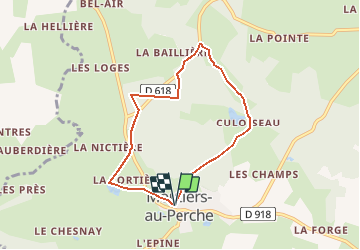
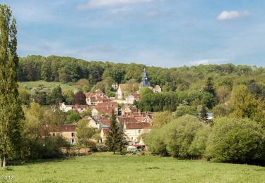
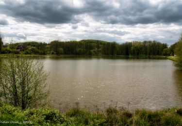
Tocht Stappen van 6,3 km beschikbaar op Normandië, Orne, Moutiers-au-Perche. Deze tocht wordt voorgesteld door tracegps.
Beschrijving
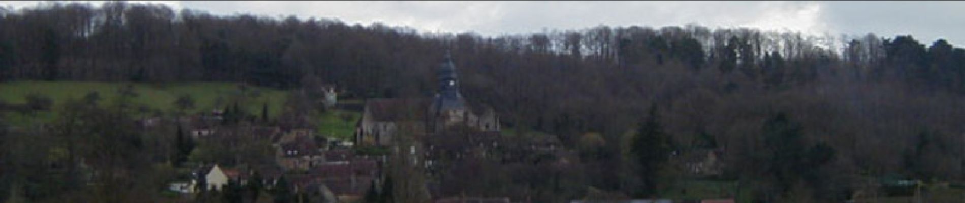
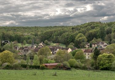
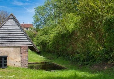
Perche authentique - Moutiers-au-Perche. Partez à la découverte d'un village de caractère et d'un domaine agricole réparti en herbages, bois et étangs. Retrouvez les Coup de Cœur Randonnée dans l’Orne en Normandie.
Plaatsbepaling
Land:
France
Regio :
Normandië
Departement/Provincie :
Orne
Gemeente :
Moutiers-au-Perche
Locatie:
Unknown
Vertrek:(Dec)
Vertrek:(UTM)
340749 ; 5371546 (31U) N.
Opmerkingen
Wandeltochten in de omgeving
![Tocht Stappen La Madeleine-Bouvet - Les belles vues de Saint-Laumer et de la Madeleine Variante 10 Km - Photo](https://media.geolcdn.com/t/375/260/87362449-0ee3-40df-8df0-c17fd7220994.jpg&format=jpg&maxdim=2)
![Stappen Stappen](https://static1.geolcdn.com/sitytour/trail-icons/101.png)
Les belles vues de Saint-Laumer et de la Madeleine Variante 10 Km
Stappen
Medium
(1)
La Madeleine-Bouvet,
Normandië,
Orne,
France
![](/images/other/stat-length.png)
10,2 km | 12,2 km-effort
2h 41min
![](https://static1.geolcdn.com/siteimages/upload/files/16400158638029165_repeat_loop_refresh_sync_direction_icon.png)
Ja
![Tocht Stappen La Madeleine-Bouvet - Les belles vues de Saint-Laumer et de la Madeleine 11 Km - Photo](https://media.geolcdn.com/t/375/260/3ee85883-b7ae-45a3-90c4-8bb6a4479600.jpg&format=jpg&maxdim=2)
![Stappen Stappen](https://static1.geolcdn.com/sitytour/trail-icons/101.png)
Les belles vues de Saint-Laumer et de la Madeleine 11 Km
Stappen
Moeilijk
(1)
La Madeleine-Bouvet,
Normandië,
Orne,
France
![](/images/other/stat-length.png)
10,9 km | 13,1 km-effort
2h 52min
![](https://static1.geolcdn.com/siteimages/upload/files/16400158638029165_repeat_loop_refresh_sync_direction_icon.png)
Ja
![Tocht Stappen Moutiers-au-Perche - 2023-05-20_10h18m41_Moutiers-au-Perche Rando de Samedi - Photo](https://media.geolcdn.com/t/375/260/dd304cf5-1fa7-4625-9960-289d50411375.jpg&format=jpg&maxdim=2)
![Stappen Stappen](https://static1.geolcdn.com/sitytour/trail-icons/101.png)
2023-05-20_10h18m41_Moutiers-au-Perche Rando de Samedi
Stappen
Medium
(1)
Moutiers-au-Perche,
Normandië,
Orne,
France
![](/images/other/stat-length.png)
6,6 km | 8,8 km-effort
1h 59min
![](https://static1.geolcdn.com/siteimages/upload/files/16400158638029165_repeat_loop_refresh_sync_direction_icon.png)
Ja
![Tocht Te voet Moutiers-au-Perche - Perche authentique - Photo](https://media.geolcdn.com/t/375/260/1c5fa599-8a3f-4902-99d5-149fc7bd1ba4.jpeg&format=jpg&maxdim=2)
![Te voet Te voet](https://static1.geolcdn.com/sitytour/trail-icons/100.png)
Perche authentique
Te voet
Gemakkelijk
Moutiers-au-Perche,
Normandië,
Orne,
France
![](/images/other/stat-length.png)
6,9 km | 9 km-effort
2h 2min
![](https://static1.geolcdn.com/siteimages/upload/files/16400158638029165_repeat_loop_refresh_sync_direction_icon.png)
Ja
![Tocht Stappen Le Mage - Le Mage - Longny-au-Perche (Longny les Villages) 11 km - Photo](https://media.geolcdn.com/t/375/260/7da85c06-6bc5-432c-afb8-5444ae0d01ad.jpg&format=jpg&maxdim=2)
![Stappen Stappen](https://static1.geolcdn.com/sitytour/trail-icons/101.png)
Le Mage - Longny-au-Perche (Longny les Villages) 11 km
Stappen
Moeilijk
Le Mage,
Normandië,
Orne,
France
![](/images/other/stat-length.png)
11,2 km | 13,5 km-effort
3h 17min
![](https://static1.geolcdn.com/siteimages/upload/files/16400158638029165_repeat_loop_refresh_sync_direction_icon.png)
Neen
![Tocht Stappen Le Mage - Le Mage - Moutiers-au-Perche 9,2 km - Photo](https://media.geolcdn.com/t/375/260/2d6a74b1-d9ee-4f0d-9acb-9c00ceb2d8ab.jpg&format=jpg&maxdim=2)
![Stappen Stappen](https://static1.geolcdn.com/sitytour/trail-icons/101.png)
Le Mage - Moutiers-au-Perche 9,2 km
Stappen
Medium
Le Mage,
Normandië,
Orne,
France
![](/images/other/stat-length.png)
9,2 km | 11,5 km-effort
2h 33min
![](https://static1.geolcdn.com/siteimages/upload/files/16400158638029165_repeat_loop_refresh_sync_direction_icon.png)
Neen
![Tocht Stappen La Madeleine-Bouvet - Bretoncelles - La Madeleine-Bouvet 5,3 km - Photo](https://media.geolcdn.com/t/375/260/573e294c-51f9-41fe-8907-e8f30e9f4bad.jpg&format=jpg&maxdim=2)
![Stappen Stappen](https://static1.geolcdn.com/sitytour/trail-icons/101.png)
Bretoncelles - La Madeleine-Bouvet 5,3 km
Stappen
Medium
La Madeleine-Bouvet,
Normandië,
Orne,
France
![](/images/other/stat-length.png)
5,3 km | 6,6 km-effort
1h 28min
![](https://static1.geolcdn.com/siteimages/upload/files/16400158638029165_repeat_loop_refresh_sync_direction_icon.png)
Neen
![Tocht Stappen Bretoncelles - SityTrail - Les Douves du Grand Cumont Bretoncelles V2 15 Km - Photo](https://media.geolcdn.com/t/375/260/d3f7aac7-ac8c-46dc-96d3-852253cb1421.jpg&format=jpg&maxdim=2)
![Stappen Stappen](https://static1.geolcdn.com/sitytour/trail-icons/101.png)
SityTrail - Les Douves du Grand Cumont Bretoncelles V2 15 Km
Stappen
Moeilijk
(1)
Bretoncelles,
Normandië,
Orne,
France
![](/images/other/stat-length.png)
14,8 km | 18,1 km-effort
4h 4min
![](https://static1.geolcdn.com/siteimages/upload/files/16400158638029165_repeat_loop_refresh_sync_direction_icon.png)
Ja
![Tocht Stappen Bretoncelles - SityTrail - Le Petit Houx du Parc - Bretoncelles 5,1 Km - Photo](https://media.geolcdn.com/t/375/260/7bdb7e04-5754-4fe7-8144-30a332f42ad5.jpg&format=jpg&maxdim=2)
![Stappen Stappen](https://static1.geolcdn.com/sitytour/trail-icons/101.png)
SityTrail - Le Petit Houx du Parc - Bretoncelles 5,1 Km
Stappen
Gemakkelijk
Bretoncelles,
Normandië,
Orne,
France
![](/images/other/stat-length.png)
5,1 km | 6,2 km-effort
1h 20min
![](https://static1.geolcdn.com/siteimages/upload/files/16400158638029165_repeat_loop_refresh_sync_direction_icon.png)
Ja