![](/images/other/stat-length.png)
![Tocht Sneeuwschoenen Bagnères-de-Luchon - L'Hospice de France en raquettes - Photo](https://media.geolcdn.com/t/1900/400/ext.pjpeg?maxdim=2&url=https%3A%2F%2Fservices.sitytrail.com%2FGeolivesWS%2FDownloadMedia.ashx%3FTrailID%3D111487%26Media%3D7443_2.jpg)
L'Hospice de France en raquettes
tracegps
Gebruiker
![Lengte](/images/other/stat-length.png)
Lengte
12,7 km
![Max. hoogte](https://static1.geolcdn.com/siteimages/upload/files/1508320355ic_sort_altitude_max_24dp.png)
Max. hoogte
1388 m
![Positief hoogteverschil](https://static1.geolcdn.com/siteimages/upload/files/1508320355ic_sort_den_pos_24dp.png)
Positief hoogteverschil
574 m
![Km-Effort](/images/other/stat-length.png)
Km-Effort
20 km
![Min. hoogte](https://static1.geolcdn.com/siteimages/upload/files/1508320355ic_sort_altitude_min_24dp.png)
Min. hoogte
827 m
![Negatief hoogteverschil](https://static1.geolcdn.com/siteimages/upload/files/1508320355ic_sort_den_neg_24dp.png)
Negatief hoogteverschil
574 m
![Boucle](https://static1.geolcdn.com/siteimages/upload/files/16400158638029165_repeat_loop_refresh_sync_direction_icon.png)
Boucle
Ja
Datum van aanmaak :
2014-12-10 00:00:00.0
Laatste wijziging :
2014-12-10 00:00:00.0
![Sneeuwschoenen](https://static1.geolcdn.com/sitytour/trail-icons/504.png)
5h00
Moeilijkheid : Medium
![Scan deze QR-code om de tocht te openen in de SityTrail-applicatie](https://capi.geolives.com/qq0zvz2zws4bq2lad0pu/sitytour/trails/111487/qr.png?size=200)
Gratisgps-wandelapplicatie
Over ons
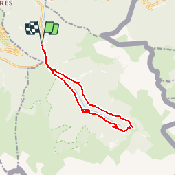
Tocht Sneeuwschoenen van 12,7 km beschikbaar op Occitanië, Haute-Garonne, Bagnères-de-Luchon. Deze tocht wordt voorgesteld door tracegps.
Beschrijving
Une randonnée raquettes en boucle pour aller à l'Hospice de France depuis Ravi en passant par la D125 pour monter et par l'ancien chemin dans la forêt pour redescendre.
Plaatsbepaling
Land:
France
Regio :
Occitanië
Departement/Provincie :
Haute-Garonne
Gemeente :
Bagnères-de-Luchon
Locatie:
Unknown
Vertrek:(Dec)
Vertrek:(UTM)
304330 ; 4736021 (31T) N.
Opmerkingen
Wandeltochten in de omgeving
![Tocht Stappen Saint-Mamet - Fonds de Burbe - Saint Mamet - Photo](https://media.geolcdn.com/t/375/260/ext.jpg?maxdim=2&url=https%3A%2F%2Fservices.sitytrail.com%2FGeolivesWS%2FDownloadMedia.ashx%3FTrailID%3D317900%26Media%3D17313_6.jpg)
![Stappen Stappen](https://static1.geolcdn.com/sitytour/trail-icons/101.png)
Fonds de Burbe - Saint Mamet
Stappen
Moeilijk
(1)
Saint-Mamet,
Occitanië,
Haute-Garonne,
France
![](/images/other/stat-length.png)
15,6 km | 27 km-effort
4h 0min
![](https://static1.geolcdn.com/siteimages/upload/files/16400158638029165_repeat_loop_refresh_sync_direction_icon.png)
Ja
![Tocht Mountainbike Saint-Aventin - Luchon Kbour - Photo](https://media.geolcdn.com/t/375/260/ext.jpg?maxdim=2&url=https%3A%2F%2Fservices.sitytrail.com%2FGeolivesWS%2FDownloadMedia.ashx%3FTrailID%3D316870%26Media%3D15951_6.jpg)
![Mountainbike Mountainbike](https://static1.geolcdn.com/sitytour/trail-icons/202.png)
Luchon Kbour
Mountainbike
Zeer moeilijk
(1)
Saint-Aventin,
Occitanië,
Haute-Garonne,
France
![](/images/other/stat-length.png)
11 km | 16,7 km-effort
1h 0min
![](https://static1.geolcdn.com/siteimages/upload/files/16400158638029165_repeat_loop_refresh_sync_direction_icon.png)
Neen
![Tocht Stappen Bagnères-de-Luchon - 2022-06-28_22h13m18_chemin_de_l'impératrice_entre_l'hospice_de_france_ - Photo](https://media.geolcdn.com/t/375/260/ext.jpg?maxdim=2&url=https%3A%2F%2Fstatic1.geolcdn.com%2Fsiteimages%2Fupload%2Ffiles%2F1553511878bg_sport_marche.png)
![Stappen Stappen](https://static1.geolcdn.com/sitytour/trail-icons/101.png)
2022-06-28_22h13m18_chemin_de_l'impératrice_entre_l'hospice_de_france_
Stappen
Medium
(1)
Bagnères-de-Luchon,
Occitanië,
Haute-Garonne,
France
![](/images/other/stat-length.png)
5,4 km | 8,8 km-effort
2h 0min
![](https://static1.geolcdn.com/siteimages/upload/files/16400158638029165_repeat_loop_refresh_sync_direction_icon.png)
Neen
![Tocht Te voet Castillon-de-Larboust - Lac Vert, Boucle par l'Est - Photo](https://media.geolcdn.com/t/375/260/1cb240b3-a0f5-41eb-84f2-0d4dbcde9df6.jpeg&format=jpg&maxdim=2)
![Te voet Te voet](https://static1.geolcdn.com/sitytour/trail-icons/100.png)
Lac Vert, Boucle par l'Est
Te voet
Gemakkelijk
Castillon-de-Larboust,
Occitanië,
Haute-Garonne,
France
![](/images/other/stat-length.png)
8,8 km | 19,5 km-effort
4h 26min
![](https://static1.geolcdn.com/siteimages/upload/files/16400158638029165_repeat_loop_refresh_sync_direction_icon.png)
Neen
![Te voet Te voet](https://static1.geolcdn.com/sitytour/trail-icons/100.png)
SityTrail - pic de Sauvegarde
Te voet
Moeilijk
Bagnères-de-Luchon,
Occitanië,
Haute-Garonne,
France
![](/images/other/stat-length.png)
8,5 km | 22 km-effort
8h 0min
![](https://static1.geolcdn.com/siteimages/upload/files/16400158638029165_repeat_loop_refresh_sync_direction_icon.png)
Neen
![Tocht Stappen Bagnères-de-Luchon - GR 10 - 3 - Photo](https://media.geolcdn.com/t/375/260/ext.jpg?maxdim=2&url=https%3A%2F%2Fstatic1.geolcdn.com%2Fsiteimages%2Fupload%2Ffiles%2F1553511878bg_sport_marche.png)
![Stappen Stappen](https://static1.geolcdn.com/sitytour/trail-icons/101.png)
GR 10 - 3
Stappen
Medium
(2)
Bagnères-de-Luchon,
Occitanië,
Haute-Garonne,
France
![](/images/other/stat-length.png)
250 km | 489 km-effort
89h 8min
![](https://static1.geolcdn.com/siteimages/upload/files/16400158638029165_repeat_loop_refresh_sync_direction_icon.png)
Neen
![Tocht Stappen Bagnères-de-Luchon - pic de Sauvegarde - Photo](https://media.geolcdn.com/t/375/260/ext.jpg?maxdim=2&url=https%3A%2F%2Fstatic1.geolcdn.com%2Fsiteimages%2Fupload%2Ffiles%2F1553511878bg_sport_marche.png)
![Stappen Stappen](https://static1.geolcdn.com/sitytour/trail-icons/101.png)
pic de Sauvegarde
Stappen
Medium
(2)
Bagnères-de-Luchon,
Occitanië,
Haute-Garonne,
France
![](/images/other/stat-length.png)
9,7 km | 25 km-effort
3h 9min
![](https://static1.geolcdn.com/siteimages/upload/files/16400158638029165_repeat_loop_refresh_sync_direction_icon.png)
Neen
![Tocht Stappen Bagnères-de-Luchon - Pic de Pouylané - Entecade - Hospice de France - Photo](https://media.geolcdn.com/t/375/260/ext.jpg?maxdim=2&url=https%3A%2F%2Fstatic1.geolcdn.com%2Fsiteimages%2Fupload%2Ffiles%2F1553511878bg_sport_marche.png)
![Stappen Stappen](https://static1.geolcdn.com/sitytour/trail-icons/101.png)
Pic de Pouylané - Entecade - Hospice de France
Stappen
Moeilijk
(1)
Bagnères-de-Luchon,
Occitanië,
Haute-Garonne,
France
![](/images/other/stat-length.png)
10,6 km | 24 km-effort
5h 39min
![](https://static1.geolcdn.com/siteimages/upload/files/16400158638029165_repeat_loop_refresh_sync_direction_icon.png)
Ja
![Tocht Stappen Bagnères-de-Luchon - Luchon via Saint Mamet - Photo](https://media.geolcdn.com/t/375/260/14945a1e-90fc-4d0d-9f7d-654cdbb4ea1f.jpg&format=jpg&maxdim=2)
![Stappen Stappen](https://static1.geolcdn.com/sitytour/trail-icons/101.png)
Luchon via Saint Mamet
Stappen
Medium
Bagnères-de-Luchon,
Occitanië,
Haute-Garonne,
France
![](/images/other/stat-length.png)
6,3 km | 9,6 km-effort
1h 47min
![](https://static1.geolcdn.com/siteimages/upload/files/16400158638029165_repeat_loop_refresh_sync_direction_icon.png)
Ja