![](/images/other/stat-length.png)
![Tocht Stappen Boissy-le-Sec - Venant (91) PC mars 2019 - Photo](https://media.geolcdn.com/t/1900/400/ext.pjpeg?maxdim=2&url=https%3A%2F%2Fstatic1.geolcdn.com%2Fsiteimages%2Fupload%2Ffiles%2F1553511878bg_sport_marche.png)
Venant (91) PC mars 2019
CRUZILLACP
Gebruiker
![Lengte](/images/other/stat-length.png)
Lengte
11,2 km
![Max. hoogte](https://static1.geolcdn.com/siteimages/upload/files/1508320355ic_sort_altitude_max_24dp.png)
Max. hoogte
152 m
![Positief hoogteverschil](https://static1.geolcdn.com/siteimages/upload/files/1508320355ic_sort_den_pos_24dp.png)
Positief hoogteverschil
139 m
![Km-Effort](/images/other/stat-length.png)
Km-Effort
13,1 km
![Min. hoogte](https://static1.geolcdn.com/siteimages/upload/files/1508320355ic_sort_altitude_min_24dp.png)
Min. hoogte
95 m
![Negatief hoogteverschil](https://static1.geolcdn.com/siteimages/upload/files/1508320355ic_sort_den_neg_24dp.png)
Negatief hoogteverschil
142 m
![Boucle](https://static1.geolcdn.com/siteimages/upload/files/16400158638029165_repeat_loop_refresh_sync_direction_icon.png)
Boucle
Ja
Datum van aanmaak :
2019-05-06 15:32:49.464
Laatste wijziging :
2019-05-06 15:32:49.464
![Stappen](https://static1.geolcdn.com/sitytour/trail-icons/101.png)
1h55
Moeilijkheid : Medium
![Scan deze QR-code om de tocht te openen in de SityTrail-applicatie](https://capi.geolives.com/qq0zvz2zws4bq2lad0pu/sitytour/trails/1114782/qr.png?size=200)
Gratisgps-wandelapplicatie
Over ons
Tocht Stappen van 11,2 km beschikbaar op Île-de-France, Essonne, Boissy-le-Sec. Deze tocht wordt voorgesteld door CRUZILLACP.
Beschrijving
Venant, Fourchainville, Boissy-le-Sec, Le Rotoir
Promenade dans Boissy-le-Sec
Départ à Venant rue de Villeneuve au 1er stop à gauche
Plaatsbepaling
Land:
France
Regio :
Île-de-France
Departement/Provincie :
Essonne
Gemeente :
Boissy-le-Sec
Locatie:
Unknown
Vertrek:(Dec)
Vertrek:(UTM)
433092 ; 5372847 (31U) N.
Opmerkingen
Wandeltochten in de omgeving
![Tocht Stappen Sermaise - 2018-09-26 Rando Sermaise - Photo](https://media.geolcdn.com/t/375/260/ext.jpg?maxdim=2&url=https%3A%2F%2Fstatic1.geolcdn.com%2Fsiteimages%2Fupload%2Ffiles%2F1553511878bg_sport_marche.png)
![Stappen Stappen](https://static1.geolcdn.com/sitytour/trail-icons/101.png)
2018-09-26 Rando Sermaise
Stappen
Gemakkelijk
(1)
Sermaise,
Île-de-France,
Essonne,
France
![](/images/other/stat-length.png)
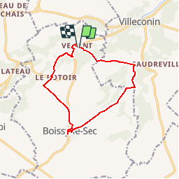
12,3 km | 15 km-effort
3h 15min
![](https://static1.geolcdn.com/siteimages/upload/files/16400158638029165_repeat_loop_refresh_sync_direction_icon.png)
Ja
![Tocht Stappen La Forêt-le-Roi - 2012-10-01 Rando des 3 Villages - Photo](https://media.geolcdn.com/t/375/260/ext.jpg?maxdim=2&url=https%3A%2F%2Fstatic1.geolcdn.com%2Fsiteimages%2Fupload%2Ffiles%2F1553511878bg_sport_marche.png)
![Stappen Stappen](https://static1.geolcdn.com/sitytour/trail-icons/101.png)
2012-10-01 Rando des 3 Villages
Stappen
Medium
(1)
La Forêt-le-Roi,
Île-de-France,
Essonne,
France
![](/images/other/stat-length.png)
20 km | 23 km-effort
5h 0min
![](https://static1.geolcdn.com/siteimages/upload/files/16400158638029165_repeat_loop_refresh_sync_direction_icon.png)
Ja
![Tocht Stappen Saint-Chéron - Saint-Cheron - l'Orge - Photo](https://media.geolcdn.com/t/375/260/2bdcf5f2-4f95-4613-9437-acb9feb0586a.jpg&format=jpg&maxdim=2)
![Stappen Stappen](https://static1.geolcdn.com/sitytour/trail-icons/101.png)
Saint-Cheron - l'Orge
Stappen
Medium
Saint-Chéron,
Île-de-France,
Essonne,
France
![](/images/other/stat-length.png)
8,3 km | 10,4 km-effort
2h 21min
![](https://static1.geolcdn.com/siteimages/upload/files/16400158638029165_repeat_loop_refresh_sync_direction_icon.png)
Ja
![Tocht Stappen Villeconin - Villeconin - Photo](https://media.geolcdn.com/t/375/260/4c2738cd-d8e9-4cad-ac5e-3768674ab35a.jpg&format=jpg&maxdim=2)
![Stappen Stappen](https://static1.geolcdn.com/sitytour/trail-icons/101.png)
Villeconin
Stappen
Medium
Villeconin,
Île-de-France,
Essonne,
France
![](/images/other/stat-length.png)
8,5 km | 10,9 km-effort
2h 11min
![](https://static1.geolcdn.com/siteimages/upload/files/16400158638029165_repeat_loop_refresh_sync_direction_icon.png)
Ja
![Tocht Stappen Souzy-la-Briche - Carrières de Madagascar à Souzy-la-Briche - Photo](https://media.geolcdn.com/t/375/260/0f9513b2-1071-4ba6-b14f-79d6a1abd29d.jpg&format=jpg&maxdim=2)
![Stappen Stappen](https://static1.geolcdn.com/sitytour/trail-icons/101.png)
Carrières de Madagascar à Souzy-la-Briche
Stappen
Medium
Souzy-la-Briche,
Île-de-France,
Essonne,
France
![](/images/other/stat-length.png)
6,8 km | 8,3 km-effort
1h 52min
![](https://static1.geolcdn.com/siteimages/upload/files/16400158638029165_repeat_loop_refresh_sync_direction_icon.png)
Ja
![Tocht Stappen Souzy-la-Briche - Rumba à Souzy la briche - Photo](https://media.geolcdn.com/t/375/260/68db3e74-0cc6-4415-a9d1-7d90a1f1f098.jpg&format=jpg&maxdim=2)
![Stappen Stappen](https://static1.geolcdn.com/sitytour/trail-icons/101.png)
Rumba à Souzy la briche
Stappen
Gemakkelijk
Souzy-la-Briche,
Île-de-France,
Essonne,
France
![](/images/other/stat-length.png)
7,6 km | 9,3 km-effort
2h 29min
![](https://static1.geolcdn.com/siteimages/upload/files/16400158638029165_repeat_loop_refresh_sync_direction_icon.png)
Ja
![Tocht Te voet Boissy-le-Sec - Sur les traces de la Renarde - Photo](https://media.geolcdn.com/t/375/260/030e88b2-7a55-4aa9-820f-6af358b12e69.jpeg&format=jpg&maxdim=2)
![Te voet Te voet](https://static1.geolcdn.com/sitytour/trail-icons/100.png)
Sur les traces de la Renarde
Te voet
Gemakkelijk
Boissy-le-Sec,
Île-de-France,
Essonne,
France
![](/images/other/stat-length.png)
6,3 km | 7,4 km-effort
1h 40min
![](https://static1.geolcdn.com/siteimages/upload/files/16400158638029165_repeat_loop_refresh_sync_direction_icon.png)
Neen
![Tocht Noords wandelen Saint-Chéron - carrière Saint chérion - Photo](https://media.geolcdn.com/t/375/260/7a5ccaf6-47ec-485d-b51b-aceb21d3f457.jpg&format=jpg&maxdim=2)
![Noords wandelen Noords wandelen](https://static1.geolcdn.com/sitytour/trail-icons/102.png)
carrière Saint chérion
Noords wandelen
Heel gemakkelijk
Saint-Chéron,
Île-de-France,
Essonne,
France
![](/images/other/stat-length.png)
10,3 km | 12,3 km-effort
2h 32min
![](https://static1.geolcdn.com/siteimages/upload/files/16400158638029165_repeat_loop_refresh_sync_direction_icon.png)
Ja
![Tocht Stappen Saint-Chéron - Saint Chéron Héliomonde château de Blaville La Tuilerie - Photo](https://media.geolcdn.com/t/375/260/e34daf0a-2bf0-4f0e-8606-ae395d442809.jpg&format=jpg&maxdim=2)
![Stappen Stappen](https://static1.geolcdn.com/sitytour/trail-icons/101.png)
Saint Chéron Héliomonde château de Blaville La Tuilerie
Stappen
Gemakkelijk
Saint-Chéron,
Île-de-France,
Essonne,
France
![](/images/other/stat-length.png)
11,2 km | 14,4 km-effort
3h 15min
![](https://static1.geolcdn.com/siteimages/upload/files/16400158638029165_repeat_loop_refresh_sync_direction_icon.png)
Neen