![](/images/other/stat-length.png)
![Tocht Fiets Chalabre - CCS FFC Aude en Pyrénées - Circuit n°01 - Chalabre - Photo](https://media.geolcdn.com/t/1900/400/ext.pjpeg?maxdim=2&url=https%3A%2F%2Fservices.sitytrail.com%2FGeolivesWS%2FDownloadMedia.ashx%3FTrailID%3D111460%26Media%3D7343_2.jpg)
CCS FFC Aude en Pyrénées - Circuit n°01 - Chalabre
tracegps
Gebruiker
![Lengte](/images/other/stat-length.png)
Lengte
29 km
![Max. hoogte](https://static1.geolcdn.com/siteimages/upload/files/1508320355ic_sort_altitude_max_24dp.png)
Max. hoogte
467 m
![Positief hoogteverschil](https://static1.geolcdn.com/siteimages/upload/files/1508320355ic_sort_den_pos_24dp.png)
Positief hoogteverschil
385 m
![Km-Effort](/images/other/stat-length.png)
Km-Effort
34 km
![Min. hoogte](https://static1.geolcdn.com/siteimages/upload/files/1508320355ic_sort_altitude_min_24dp.png)
Min. hoogte
332 m
![Negatief hoogteverschil](https://static1.geolcdn.com/siteimages/upload/files/1508320355ic_sort_den_neg_24dp.png)
Negatief hoogteverschil
384 m
![Boucle](https://static1.geolcdn.com/siteimages/upload/files/16400158638029165_repeat_loop_refresh_sync_direction_icon.png)
Boucle
Ja
Datum van aanmaak :
2014-12-10 00:00:00.0
Laatste wijziging :
2014-12-10 00:00:00.0
![Fiets](https://static1.geolcdn.com/sitytour/trail-icons/200.png)
1h30
Moeilijkheid : Medium
![Scan deze QR-code om de tocht te openen in de SityTrail-applicatie](https://capi.geolives.com/qq0zvz2zws4bq2lad0pu/sitytour/trails/111460/qr.png?size=200)
Gratisgps-wandelapplicatie
Over ons
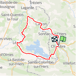
Tocht Fiets van 29 km beschikbaar op Occitanië, Aude, Chalabre. Deze tocht wordt voorgesteld door tracegps.
Beschrijving
Parcours sans grande difficulté, qui vous amène du village fortifié de Camon et son ancienne abbaye au château de Léran. Il ménage de beaux panoramas sur les Pyrénées et le lac de Montbel. Textes de Patrick Rault et Louis Mounié.
Plaatsbepaling
Land:
France
Regio :
Occitanië
Departement/Provincie :
Aude
Gemeente :
Chalabre
Locatie:
Unknown
Vertrek:(Dec)
Vertrek:(UTM)
419072 ; 4759474 (31T) N.
Opmerkingen
Wandeltochten in de omgeving
![Tocht Stappen Rivel - Au fil de l'eau - Rivel - Photo](https://media.geolcdn.com/t/375/260/ext.jpg?maxdim=2&url=https%3A%2F%2Fservices.sitytrail.com%2FGeolivesWS%2FDownloadMedia.ashx%3FTrailID%3D111543%26Media%3D7620_6.jpg)
![Stappen Stappen](https://static1.geolcdn.com/sitytour/trail-icons/101.png)
Au fil de l'eau - Rivel
Stappen
Medium
(1)
Rivel,
Occitanië,
Aude,
France
![](/images/other/stat-length.png)
5,2 km | 7 km-effort
1h 45min
![](https://static1.geolcdn.com/siteimages/upload/files/16400158638029165_repeat_loop_refresh_sync_direction_icon.png)
Ja
![Tocht Stappen Rivel - Le chemin du château - Rivel - Photo](https://media.geolcdn.com/t/375/260/ext.jpg?maxdim=2&url=https%3A%2F%2Fservices.sitytrail.com%2FGeolivesWS%2FDownloadMedia.ashx%3FTrailID%3D111547%26Media%3D7636_6.jpg)
![Stappen Stappen](https://static1.geolcdn.com/sitytour/trail-icons/101.png)
Le chemin du château - Rivel
Stappen
Gemakkelijk
(1)
Rivel,
Occitanië,
Aude,
France
![](/images/other/stat-length.png)
2,4 km | 4 km-effort
45min
![](https://static1.geolcdn.com/siteimages/upload/files/16400158638029165_repeat_loop_refresh_sync_direction_icon.png)
Ja
![Tocht Stappen Montbel - Lac de Montbel - Photo](https://media.geolcdn.com/t/375/260/ext.jpg?maxdim=2&url=https%3A%2F%2Fservices.sitytrail.com%2FGeolivesWS%2FDownloadMedia.ashx%3FTrailID%3D108634%26Media%3D1546_1.jpg)
![Stappen Stappen](https://static1.geolcdn.com/sitytour/trail-icons/101.png)
Lac de Montbel
Stappen
Medium
(2)
Montbel,
Occitanië,
Ariège,
France
![](/images/other/stat-length.png)
15,8 km | 18,4 km-effort
3h 19min
![](https://static1.geolcdn.com/siteimages/upload/files/16400158638029165_repeat_loop_refresh_sync_direction_icon.png)
Ja
![Tocht Stappen Montbel - 1/2 - Photo](https://media.geolcdn.com/t/375/260/04f81fef-1f32-4c7b-bbc0-0fcf03103e41.jpg&format=jpg&maxdim=2)
![Stappen Stappen](https://static1.geolcdn.com/sitytour/trail-icons/101.png)
![Tocht Te voet Montbel - Tour du Lac de Montbel - Photo](https://media.geolcdn.com/t/375/260/25dcfb65-b7fe-4eef-9118-1046e41dc897.jpeg&format=jpg&maxdim=2)
![Te voet Te voet](https://static1.geolcdn.com/sitytour/trail-icons/100.png)
Tour du Lac de Montbel
Te voet
Gemakkelijk
Montbel,
Occitanië,
Ariège,
France
![](/images/other/stat-length.png)
15,3 km | 17,9 km-effort
4h 4min
![](https://static1.geolcdn.com/siteimages/upload/files/16400158638029165_repeat_loop_refresh_sync_direction_icon.png)
Ja
![Tocht Fiets Chalabre - Chalabre - Limoux - Espéraza - Photo](https://media.geolcdn.com/t/375/260/ext.jpg?maxdim=2&url=https%3A%2F%2Fservices.sitytrail.com%2FGeolivesWS%2FDownloadMedia.ashx%3FTrailID%3D316835%26Media%3D15898_3.jpg)
![Fiets Fiets](https://static1.geolcdn.com/sitytour/trail-icons/200.png)
Chalabre - Limoux - Espéraza
Fiets
Moeilijk
Chalabre,
Occitanië,
Aude,
France
![](/images/other/stat-length.png)
72 km | 88 km-effort
4h 30min
![](https://static1.geolcdn.com/siteimages/upload/files/16400158638029165_repeat_loop_refresh_sync_direction_icon.png)
Ja
![Tocht Paard Chalabre - La colline du calvaire - Chalabre - Photo](https://media.geolcdn.com/t/375/260/ext.jpg?maxdim=2&url=https%3A%2F%2Fservices.sitytrail.com%2FGeolivesWS%2FDownloadMedia.ashx%3FTrailID%3D111541%26Media%3D7599_4.jpg)
![Paard Paard](https://static1.geolcdn.com/sitytour/trail-icons/300.png)
La colline du calvaire - Chalabre
Paard
Gemakkelijk
Chalabre,
Occitanië,
Aude,
France
![](/images/other/stat-length.png)
4,4 km | 6,4 km-effort
1h 0min
![](https://static1.geolcdn.com/siteimages/upload/files/16400158638029165_repeat_loop_refresh_sync_direction_icon.png)
Ja
![Tocht Stappen Chalabre - La colline du calvaire - Chalabre - Photo](https://media.geolcdn.com/t/375/260/ext.jpg?maxdim=2&url=https%3A%2F%2Fservices.sitytrail.com%2FGeolivesWS%2FDownloadMedia.ashx%3FTrailID%3D111540%26Media%3D7599_4.jpg)
![Stappen Stappen](https://static1.geolcdn.com/sitytour/trail-icons/101.png)
La colline du calvaire - Chalabre
Stappen
Gemakkelijk
Chalabre,
Occitanië,
Aude,
France
![](/images/other/stat-length.png)
4,4 km | 6,4 km-effort
1h 30min
![](https://static1.geolcdn.com/siteimages/upload/files/16400158638029165_repeat_loop_refresh_sync_direction_icon.png)
Ja
![Tocht Stappen Chalabre - Circuit de découverte de Chalabre - Photo](https://media.geolcdn.com/t/375/260/ext.jpg?maxdim=2&url=https%3A%2F%2Fservices.sitytrail.com%2FGeolivesWS%2FDownloadMedia.ashx%3FTrailID%3D111539%26Media%3D7598_6.jpg)
![Stappen Stappen](https://static1.geolcdn.com/sitytour/trail-icons/101.png)
Circuit de découverte de Chalabre
Stappen
Gemakkelijk
Chalabre,
Occitanië,
Aude,
France
![](/images/other/stat-length.png)
3,5 km | 3,9 km-effort
1h 0min
![](https://static1.geolcdn.com/siteimages/upload/files/16400158638029165_repeat_loop_refresh_sync_direction_icon.png)
Ja