![](/images/other/stat-length.png)
![Tocht Stappen Oloron-Sainte-Marie - Sentier karstique - Piémont Oloronais - Photo](https://media.geolcdn.com/t/1900/400/ext.pjpeg?maxdim=2&url=https%3A%2F%2Fservices.sitytrail.com%2FGeolivesWS%2FDownloadMedia.ashx%3FTrailID%3D111311%26Media%3D6977_1.jpg)
Sentier karstique - Piémont Oloronais
tracegps
Gebruiker
![Lengte](/images/other/stat-length.png)
![Max. hoogte](https://static1.geolcdn.com/siteimages/upload/files/1508320355ic_sort_altitude_max_24dp.png)
![Positief hoogteverschil](https://static1.geolcdn.com/siteimages/upload/files/1508320355ic_sort_den_pos_24dp.png)
![Km-Effort](/images/other/stat-length.png)
![Min. hoogte](https://static1.geolcdn.com/siteimages/upload/files/1508320355ic_sort_altitude_min_24dp.png)
![Negatief hoogteverschil](https://static1.geolcdn.com/siteimages/upload/files/1508320355ic_sort_den_neg_24dp.png)
![Boucle](https://static1.geolcdn.com/siteimages/upload/files/16400158638029165_repeat_loop_refresh_sync_direction_icon.png)
![Stappen](https://static1.geolcdn.com/sitytour/trail-icons/101.png)
1h00
Moeilijkheid : Gemakkelijk
![Scan deze QR-code om de tocht te openen in de SityTrail-applicatie](https://capi.geolives.com/qq0zvz2zws4bq2lad0pu/sitytour/trails/111311/qr.png?size=200)
Gratisgps-wandelapplicatie
Over ons
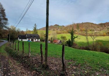
Tocht Stappen van 2,7 km beschikbaar op Nieuw-Aquitanië, Pyrénées-Atlantiques, Oloron-Sainte-Marie. Deze tocht wordt voorgesteld door tracegps.
Beschrijving
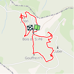
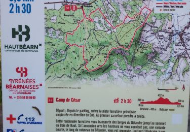
Unique en son genre et spectaculaire, cet itinéraire qui va de gouffre en gouffre est une porte ouverte sur le monde souterrain. Sur un sentier forestier et par des passerelles au-dessus des grottes, vous découvrirez, le temps d´une balade familiale,l´immense et insoupçonnable réseau de cavités ouvertes sous nos pieds. Retrouvez d’autres informations et la fiche descriptive sur le site Pays Basque et Béarn.
Plaatsbepaling
Opmerkingen
Wandeltochten in de omgeving
![Tocht Lopen Oloron-Sainte-Marie - OLORON Le camp de Cesar G4](https://media.geolcdn.com/t/375/260/e472b0d2-5d8f-43de-b167-1446063f7ed6.jpg&format=jpg&maxdim=2)
![Lopen Lopen](https://static1.geolcdn.com/sitytour/trail-icons/103.png)
Lopen
![](/images/other/stat-length.png)
![](https://static1.geolcdn.com/siteimages/upload/files/16400158638029165_repeat_loop_refresh_sync_direction_icon.png)
![Tocht Te voet Oloron-Sainte-Marie - OLORON / LURBE - SAINT CHRISTAUD balisage GR 653 balisage - Photo](https://media.geolcdn.com/t/375/260/3e9828ef-bc7b-413a-8d74-e856dfe267ad.jpg&format=jpg&maxdim=2)
![Te voet Te voet](https://static1.geolcdn.com/sitytour/trail-icons/100.png)
Te voet
![](/images/other/stat-length.png)
![](https://static1.geolcdn.com/siteimages/upload/files/16400158638029165_repeat_loop_refresh_sync_direction_icon.png)
![Tocht Stappen Ance-Féas - Ance Unars G3 2021 - Photo](https://media.geolcdn.com/t/375/260/5484398e-627e-4050-b331-9b372303d130.jpg&format=jpg&maxdim=2)
![Stappen Stappen](https://static1.geolcdn.com/sitytour/trail-icons/101.png)
Stappen
![](/images/other/stat-length.png)
![](https://static1.geolcdn.com/siteimages/upload/files/16400158638029165_repeat_loop_refresh_sync_direction_icon.png)
![Tocht Stappen Oloron-Sainte-Marie - G4 Haut doloron - Photo](https://media.geolcdn.com/t/375/260/62971c8b-edeb-4f82-8ed6-042d0d814008.jpg&format=jpg&maxdim=2)
![Stappen Stappen](https://static1.geolcdn.com/sitytour/trail-icons/101.png)
Stappen
![](/images/other/stat-length.png)
![](https://static1.geolcdn.com/siteimages/upload/files/16400158638029165_repeat_loop_refresh_sync_direction_icon.png)
![Tocht Te voet Oloron-Sainte-Marie - Move - Photo](https://media.geolcdn.com/t/375/260/ext.jpg?maxdim=2&url=https%3A%2F%2Fstatic1.geolcdn.com%2Fsiteimages%2Fupload%2Ffiles%2F1545311037marcheuse_200dpi.jpg)
![Te voet Te voet](https://static1.geolcdn.com/sitytour/trail-icons/100.png)
Te voet
![](/images/other/stat-length.png)
![](https://static1.geolcdn.com/siteimages/upload/files/16400158638029165_repeat_loop_refresh_sync_direction_icon.png)
![Tocht Stappen Oloron-Sainte-Marie - Chemin du Piémont Pyrénéen - De Oloron Sainte Marie à L'Hopital St Blaise - Photo](https://media.geolcdn.com/t/375/260/ext.jpg?maxdim=2&url=https%3A%2F%2Fservices.sitytrail.com%2FGeolivesWS%2FDownloadMedia.ashx%3FTrailID%3D111318%26Media%3D6991_1.jpg)
![Stappen Stappen](https://static1.geolcdn.com/sitytour/trail-icons/101.png)
Stappen
![](/images/other/stat-length.png)
![](https://static1.geolcdn.com/siteimages/upload/files/16400158638029165_repeat_loop_refresh_sync_direction_icon.png)
![Tocht Stappen Oloron-Sainte-Marie - test OLORON versée dans TIAGO - Photo](https://media.geolcdn.com/t/375/260/ext.jpg?maxdim=2&url=https%3A%2F%2Fstatic1.geolcdn.com%2Fsiteimages%2Fupload%2Ffiles%2F1553511878bg_sport_marche.png)
![Stappen Stappen](https://static1.geolcdn.com/sitytour/trail-icons/101.png)
Stappen
![](/images/other/stat-length.png)
![](https://static1.geolcdn.com/siteimages/upload/files/16400158638029165_repeat_loop_refresh_sync_direction_icon.png)
![Tocht Stappen Oloron-Sainte-Marie - Pyrenees-Atl - Oloron-Ste-Marie St-Pee-d-en-Bas Col de Sabareil 19km 451m - Photo](https://media.geolcdn.com/t/375/260/ext.jpg?maxdim=2&url=https%3A%2F%2Fstatic1.geolcdn.com%2Fsiteimages%2Fupload%2Ffiles%2F1553511878bg_sport_marche.png)
![Stappen Stappen](https://static1.geolcdn.com/sitytour/trail-icons/101.png)
Stappen
![](/images/other/stat-length.png)
![](https://static1.geolcdn.com/siteimages/upload/files/16400158638029165_repeat_loop_refresh_sync_direction_icon.png)
![Tocht Stappen Esquiule - G3-ESQUIULE-Sommet de Cambilhou TC - Photo](https://media.geolcdn.com/t/375/260/16eaa28c-6eac-4938-b1a8-3a1bd300a597.jpg&format=jpg&maxdim=2)
![Stappen Stappen](https://static1.geolcdn.com/sitytour/trail-icons/101.png)
Stappen
![](/images/other/stat-length.png)
![](https://static1.geolcdn.com/siteimages/upload/files/16400158638029165_repeat_loop_refresh_sync_direction_icon.png)