![](/images/other/stat-length.png)
![Tocht Stappen Itxassou - De la Nive à la Nivelle - Pic du Mondarrain - Photo](https://media.geolcdn.com/t/1900/400/ext.pjpeg?maxdim=2&url=https%3A%2F%2Fservices.sitytrail.com%2FGeolivesWS%2FDownloadMedia.ashx%3FTrailID%3D111305%26Media%3D6954_2.jpg)
De la Nive à la Nivelle - Pic du Mondarrain
tracegps
Gebruiker
![Lengte](/images/other/stat-length.png)
![Max. hoogte](https://static1.geolcdn.com/siteimages/upload/files/1508320355ic_sort_altitude_max_24dp.png)
![Positief hoogteverschil](https://static1.geolcdn.com/siteimages/upload/files/1508320355ic_sort_den_pos_24dp.png)
![Km-Effort](/images/other/stat-length.png)
![Min. hoogte](https://static1.geolcdn.com/siteimages/upload/files/1508320355ic_sort_altitude_min_24dp.png)
![Negatief hoogteverschil](https://static1.geolcdn.com/siteimages/upload/files/1508320355ic_sort_den_neg_24dp.png)
![Boucle](https://static1.geolcdn.com/siteimages/upload/files/16400158638029165_repeat_loop_refresh_sync_direction_icon.png)
![Stappen](https://static1.geolcdn.com/sitytour/trail-icons/101.png)
4h30
Moeilijkheid : Medium
![Scan deze QR-code om de tocht te openen in de SityTrail-applicatie](https://capi.geolives.com/qq0zvz2zws4bq2lad0pu/sitytour/trails/111305/qr.png?size=200)
Gratisgps-wandelapplicatie
Over ons
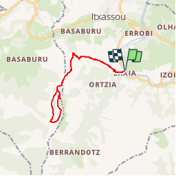
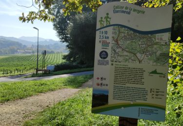
Tocht Stappen van 12,7 km beschikbaar op Nieuw-Aquitanië, Pyrénées-Atlantiques, Itxassou. Deze tocht wordt voorgesteld door tracegps.
Beschrijving
Cet itinéraire vous offre de remarquables paysages et des vues panoramiques. Vous découvrirez des ruines, vestige d´un château qui fut construit au temps des guerres entre la Navarre et l´Angleterre. Vous serez également surpris par la faune et la flore avec la découverte des tourbières de pente. Retrouvez d’autres informations et la fiche descriptive sur le site Pays Basque et Béarn.
Plaatsbepaling
Opmerkingen
Wandeltochten in de omgeving
![Tocht Stappen Itxassou - Itxassou G3 laxia - Photo](https://media.geolcdn.com/t/375/260/b99a5782-2115-4306-b331-d358915b71f8.jpg&format=jpg&maxdim=2)
![Stappen Stappen](https://static1.geolcdn.com/sitytour/trail-icons/101.png)
Stappen
![](/images/other/stat-length.png)
![](https://static1.geolcdn.com/siteimages/upload/files/16400158638029165_repeat_loop_refresh_sync_direction_icon.png)
![Tocht Stappen Espelette - Erreka mondarain col des veaux - Photo](https://media.geolcdn.com/t/375/260/3df7f8f7-bc92-4579-aed0-3a855d972fe6.jpg&format=jpg&maxdim=2)
![Stappen Stappen](https://static1.geolcdn.com/sitytour/trail-icons/101.png)
Stappen
![](/images/other/stat-length.png)
![](https://static1.geolcdn.com/siteimages/upload/files/16400158638029165_repeat_loop_refresh_sync_direction_icon.png)
![Tocht Stappen Espelette - De la Nive à la Nivelle - Circuit des familles - Espelette - Photo](https://media.geolcdn.com/t/375/260/ext.jpg?maxdim=2&url=https%3A%2F%2Fservices.sitytrail.com%2FGeolivesWS%2FDownloadMedia.ashx%3FTrailID%3D111304%26Media%3D6953_1.jpg)
![Stappen Stappen](https://static1.geolcdn.com/sitytour/trail-icons/101.png)
Stappen
![](/images/other/stat-length.png)
![](https://static1.geolcdn.com/siteimages/upload/files/16400158638029165_repeat_loop_refresh_sync_direction_icon.png)
![Tocht Stappen Espelette - ESPELETTE Le circuit des familles](https://media.geolcdn.com/t/375/260/9437414c-8a31-4a8c-95c7-86058d157002.jpg&format=jpg&maxdim=2)
![Stappen Stappen](https://static1.geolcdn.com/sitytour/trail-icons/101.png)
Stappen
![](/images/other/stat-length.png)
![](https://static1.geolcdn.com/siteimages/upload/files/16400158638029165_repeat_loop_refresh_sync_direction_icon.png)
![Tocht Stappen Cambo-les-Bains - CAMBO la grande boucle des thermes Appart Cambo bas-Cambo Thermes appart - Photo](https://media.geolcdn.com/t/375/260/a585af04-f66c-4e45-b3ed-3e19fb8d6666.jpg&format=jpg&maxdim=2)
![Stappen Stappen](https://static1.geolcdn.com/sitytour/trail-icons/101.png)
Stappen
![](/images/other/stat-length.png)
![](https://static1.geolcdn.com/siteimages/upload/files/16400158638029165_repeat_loop_refresh_sync_direction_icon.png)
![Tocht Stappen Itxassou - L'ARTZAMENDI - Photo](https://media.geolcdn.com/t/375/260/ext.jpg?maxdim=2&url=https%3A%2F%2Fstatic1.geolcdn.com%2Fsiteimages%2Fupload%2Ffiles%2F1553511878bg_sport_marche.png)
![Stappen Stappen](https://static1.geolcdn.com/sitytour/trail-icons/101.png)
Stappen
![](/images/other/stat-length.png)
![](https://static1.geolcdn.com/siteimages/upload/files/16400158638029165_repeat_loop_refresh_sync_direction_icon.png)
![Tocht Stappen Cambo-les-Bains - CAMBO la ville les thermes - Photo](https://media.geolcdn.com/t/375/260/2ef23430-557d-4607-a7ce-99a5794b8029.jpg&format=jpg&maxdim=2)
![Stappen Stappen](https://static1.geolcdn.com/sitytour/trail-icons/101.png)
Stappen
![](/images/other/stat-length.png)
![](https://static1.geolcdn.com/siteimages/upload/files/16400158638029165_repeat_loop_refresh_sync_direction_icon.png)
![Tocht Stappen Cambo-les-Bains - CAMBO terra aventura](https://media.geolcdn.com/t/375/260/5870fd65-2f61-4348-915c-917b30c6dcef.jpg&format=jpg&maxdim=2)
![Stappen Stappen](https://static1.geolcdn.com/sitytour/trail-icons/101.png)
Stappen
![](/images/other/stat-length.png)
![](https://static1.geolcdn.com/siteimages/upload/files/16400158638029165_repeat_loop_refresh_sync_direction_icon.png)
![Tocht Stappen Cambo-les-Bains - CAMBO la colline de la bergerie - Photo](https://media.geolcdn.com/t/375/260/6467105d-b365-4ce3-806f-bc2e36fb629a.jpg&format=jpg&maxdim=2)
![Stappen Stappen](https://static1.geolcdn.com/sitytour/trail-icons/101.png)
Stappen
![](/images/other/stat-length.png)
![](https://static1.geolcdn.com/siteimages/upload/files/16400158638029165_repeat_loop_refresh_sync_direction_icon.png)