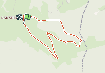
![](/images/other/stat-length.png)
![Tocht Stappen Issor - Tumulus de la serre - Issor - Photo](https://media.geolcdn.com/t/1900/400/ext.pjpeg?maxdim=2&url=https%3A%2F%2Fservices.sitytrail.com%2FGeolivesWS%2FDownloadMedia.ashx%3FTrailID%3D111303%26Media%3D6952_1.jpg)
Tumulus de la serre - Issor
tracegps
Gebruiker
![Lengte](/images/other/stat-length.png)
![Max. hoogte](https://static1.geolcdn.com/siteimages/upload/files/1508320355ic_sort_altitude_max_24dp.png)
![Positief hoogteverschil](https://static1.geolcdn.com/siteimages/upload/files/1508320355ic_sort_den_pos_24dp.png)
![Km-Effort](/images/other/stat-length.png)
![Min. hoogte](https://static1.geolcdn.com/siteimages/upload/files/1508320355ic_sort_altitude_min_24dp.png)
![Negatief hoogteverschil](https://static1.geolcdn.com/siteimages/upload/files/1508320355ic_sort_den_neg_24dp.png)
![Boucle](https://static1.geolcdn.com/siteimages/upload/files/16400158638029165_repeat_loop_refresh_sync_direction_icon.png)
![Stappen](https://static1.geolcdn.com/sitytour/trail-icons/101.png)
1h30
Moeilijkheid : Medium
![Scan deze QR-code om de tocht te openen in de SityTrail-applicatie](https://capi.geolives.com/qq0zvz2zws4bq2lad0pu/sitytour/trails/111303/qr.png?size=200)
Gratisgps-wandelapplicatie
Over ons
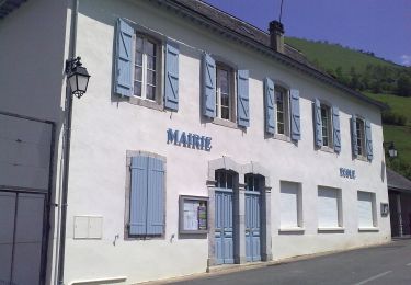
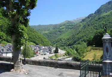
Tocht Stappen van 4,8 km beschikbaar op Nieuw-Aquitanië, Pyrénées-Atlantiques, Issor. Deze tocht wordt voorgesteld door tracegps.
Beschrijving
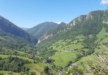
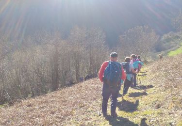
Cercles rudimentaires de pierres : les tumulus attestent d´une antique activité pastorale. Ici rien n´a changé, vous pouvez contempler les mêmes paysages que les bergers d´autrefois. Les crêtes de Soutirou et de Mustayou vous invitent à d´autres randonnées. Retrouvez d’autres informations et la fiche descriptive sur le site Pays Basque et Béarn.
Plaatsbepaling
Opmerkingen
Wandeltochten in de omgeving
![Tocht Stappen Lourdios-Ichère - Circuit les fougeraies lourdios-Ichère - Photo](https://media.geolcdn.com/t/375/260/7fb0581a-0f2a-4a22-aa40-0e0fe8fcd4ed.jpg&format=jpg&maxdim=2)
![Stappen Stappen](https://static1.geolcdn.com/sitytour/trail-icons/101.png)
Stappen
![](/images/other/stat-length.png)
![](https://static1.geolcdn.com/siteimages/upload/files/16400158638029165_repeat_loop_refresh_sync_direction_icon.png)
![Tocht Te voet Lourdios-Ichère - Col de Laünde asp07 - Photo](https://media.geolcdn.com/t/375/260/f17adf41-00db-4a52-9acd-228db570c522.jpeg&format=jpg&maxdim=2)
![Te voet Te voet](https://static1.geolcdn.com/sitytour/trail-icons/100.png)
Te voet
![](/images/other/stat-length.png)
![](https://static1.geolcdn.com/siteimages/upload/files/16400158638029165_repeat_loop_refresh_sync_direction_icon.png)
![Tocht Te voet Lourdios-Ichère - Fougeraies de Laünde asp05 - Photo](https://media.geolcdn.com/t/375/260/6ba1d2f7-3700-484c-9cfa-e7a585ba6c50.jpeg&format=jpg&maxdim=2)
![Te voet Te voet](https://static1.geolcdn.com/sitytour/trail-icons/100.png)
Te voet
![](/images/other/stat-length.png)
![](https://static1.geolcdn.com/siteimages/upload/files/16400158638029165_repeat_loop_refresh_sync_direction_icon.png)
![Tocht Te voet Sarrance - SARRANCE / ACCOUS collecte numerique GR 653 10 - Photo](https://media.geolcdn.com/t/375/260/6af0ffae-8b6f-4ace-a0bc-1da8fe58ba0f.jpg&format=jpg&maxdim=2)
![Te voet Te voet](https://static1.geolcdn.com/sitytour/trail-icons/100.png)
Te voet
![](/images/other/stat-length.png)
![](https://static1.geolcdn.com/siteimages/upload/files/16400158638029165_repeat_loop_refresh_sync_direction_icon.png)
![Tocht Te voet Escot - Tour Bilboquet-Barescou asp01 - Photo](https://media.geolcdn.com/t/375/260/55ff453c-cab8-4ca7-b81d-a7758b36c1ff.jpeg&format=jpg&maxdim=2)
![Te voet Te voet](https://static1.geolcdn.com/sitytour/trail-icons/100.png)
Te voet
![](/images/other/stat-length.png)
![](https://static1.geolcdn.com/siteimages/upload/files/16400158638029165_repeat_loop_refresh_sync_direction_icon.png)
![Tocht Stappen Escot - escot le bilboquet G3 fait - Photo](https://media.geolcdn.com/t/375/260/070b4e50-20d7-44d9-8406-b0b9c0063d99.jpg&format=jpg&maxdim=2)
![Stappen Stappen](https://static1.geolcdn.com/sitytour/trail-icons/101.png)
Stappen
![](/images/other/stat-length.png)
![](https://static1.geolcdn.com/siteimages/upload/files/16400158638029165_repeat_loop_refresh_sync_direction_icon.png)
![Tocht Trail Sarrance - Col Laundé - Photo](https://media.geolcdn.com/t/375/260/2ca6411c-420c-4c54-997a-50e1e4cfec54.jpg&format=jpg&maxdim=2)
![Trail Trail](https://static1.geolcdn.com/sitytour/trail-icons/104.png)
Trail
![](/images/other/stat-length.png)
![](https://static1.geolcdn.com/siteimages/upload/files/16400158638029165_repeat_loop_refresh_sync_direction_icon.png)
![Tocht Stappen Sarrance - Chemin d'Arles à Compostelle - Sarrance - Urdos - Photo](https://media.geolcdn.com/t/375/260/ext.jpg?maxdim=2&url=https%3A%2F%2Fservices.sitytrail.com%2FGeolivesWS%2FDownloadMedia.ashx%3FTrailID%3D105161%26Media%3D8788_1.jpg)
![Stappen Stappen](https://static1.geolcdn.com/sitytour/trail-icons/101.png)
Stappen
![](/images/other/stat-length.png)
![](https://static1.geolcdn.com/siteimages/upload/files/16400158638029165_repeat_loop_refresh_sync_direction_icon.png)
![Tocht Fietstoerisme Sarrance - SityTrail - 016 Sarrance to Somport - Photo](https://media.geolcdn.com/t/375/260/ext.jpg?maxdim=2&url=https%3A%2F%2Fstatic1.geolcdn.com%2Fsiteimages%2Fupload%2Ffiles%2F1524743154velo.jpg)
![Fietstoerisme Fietstoerisme](https://static1.geolcdn.com/sitytour/trail-icons/204.png)
Fietstoerisme
![](/images/other/stat-length.png)
![](https://static1.geolcdn.com/siteimages/upload/files/16400158638029165_repeat_loop_refresh_sync_direction_icon.png)