![](/images/other/stat-length.png)
![Tocht Stappen Orthez - Orthez - Laqueyre - Photo](https://media.geolcdn.com/t/1900/400/ext.pjpeg?maxdim=2&url=https%3A%2F%2Fservices.sitytrail.com%2FGeolivesWS%2FDownloadMedia.ashx%3FTrailID%3D111277%26Media%3D6909_1.jpg)
Orthez - Laqueyre
tracegps
Gebruiker
![Lengte](/images/other/stat-length.png)
![Max. hoogte](https://static1.geolcdn.com/siteimages/upload/files/1508320355ic_sort_altitude_max_24dp.png)
![Positief hoogteverschil](https://static1.geolcdn.com/siteimages/upload/files/1508320355ic_sort_den_pos_24dp.png)
![Km-Effort](/images/other/stat-length.png)
![Min. hoogte](https://static1.geolcdn.com/siteimages/upload/files/1508320355ic_sort_altitude_min_24dp.png)
![Negatief hoogteverschil](https://static1.geolcdn.com/siteimages/upload/files/1508320355ic_sort_den_neg_24dp.png)
![Boucle](https://static1.geolcdn.com/siteimages/upload/files/16400158638029165_repeat_loop_refresh_sync_direction_icon.png)
![Stappen](https://static1.geolcdn.com/sitytour/trail-icons/101.png)
3h00
Moeilijkheid : Medium
![Scan deze QR-code om de tocht te openen in de SityTrail-applicatie](https://capi.geolives.com/qq0zvz2zws4bq2lad0pu/sitytour/trails/111277/qr.png?size=200)
Gratisgps-wandelapplicatie
Over ons
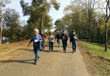
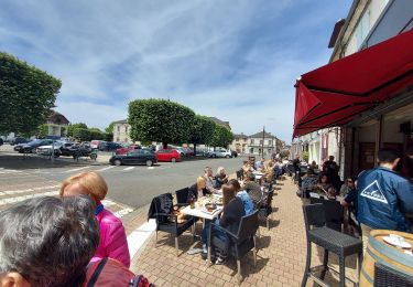
Tocht Stappen van 9,5 km beschikbaar op Nieuw-Aquitanië, Pyrénées-Atlantiques, Orthez. Deze tocht wordt voorgesteld door tracegps.
Beschrijving
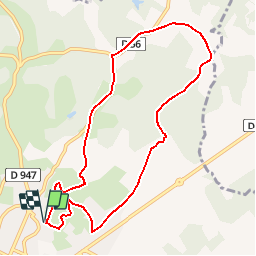
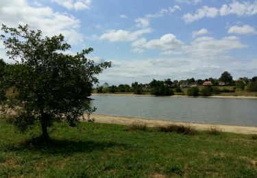
L´itinéraire se développe au nord du lac du Grécq sur les crêtes bordant le bassin versant. Les ouvertures paysagères vers Orthez ou les Pyrénées alternent avec des passages forestiers et ombragés. C´est un très ancien itinéraire qu´empruntaient les pèlerins de Compostelle et qui reliait la Tarbelli (nom latin pour désigner Dax) à Orthez par la ligne des crêtes. Retrouvez d’autres informations et la fiche descriptive sur le site Pays Basque et Béarn.
Plaatsbepaling
Opmerkingen
Wandeltochten in de omgeving
![Tocht Stappen Orthez - ORTHEZ GRvP 29 02 2024 - Photo](https://media.geolcdn.com/t/375/260/0d814157-7d95-4a00-b60d-82a6abe89f6f.jpg&format=jpg&maxdim=2)
![Stappen Stappen](https://static1.geolcdn.com/sitytour/trail-icons/101.png)
Stappen
![](/images/other/stat-length.png)
![](https://static1.geolcdn.com/siteimages/upload/files/16400158638029165_repeat_loop_refresh_sync_direction_icon.png)
![Tocht Te voet Orthez - PARI 2024 Orthez / Sault de Navailles](https://media.geolcdn.com/t/375/260/42c73725-e9b0-4ac9-ab5d-1a19c49f9c83.jpg&format=jpg&maxdim=2)
![Te voet Te voet](https://static1.geolcdn.com/sitytour/trail-icons/100.png)
Te voet
![](/images/other/stat-length.png)
![](https://static1.geolcdn.com/siteimages/upload/files/16400158638029165_repeat_loop_refresh_sync_direction_icon.png)
![Tocht Stappen Orthez - ORTHEZ Medieval (CCLO) G4 labélisation fait - Photo](https://media.geolcdn.com/t/375/260/7c0b9c05-ca7f-4f2c-ad05-418a6b8d0a7d.jpg&format=jpg&maxdim=2)
![Stappen Stappen](https://static1.geolcdn.com/sitytour/trail-icons/101.png)
Stappen
![](/images/other/stat-length.png)
![](https://static1.geolcdn.com/siteimages/upload/files/16400158638029165_repeat_loop_refresh_sync_direction_icon.png)
![Tocht Stappen Orthez - ORTHEZ Laqueyre M1 et M2 le 14/12/2022](https://media.geolcdn.com/t/375/260/ae1f1fca-c70e-431c-94e5-e096d753b3a0.jpg&format=jpg&maxdim=2)
![Stappen Stappen](https://static1.geolcdn.com/sitytour/trail-icons/101.png)
Stappen
![](/images/other/stat-length.png)
![](https://static1.geolcdn.com/siteimages/upload/files/16400158638029165_repeat_loop_refresh_sync_direction_icon.png)
![Tocht Stappen Orthez - ORTHEZ Lac de Biron - Photo](https://media.geolcdn.com/t/375/260/3ae26d80-477b-4231-89b6-5481b0ce8daf.jpg&format=jpg&maxdim=2)
![Stappen Stappen](https://static1.geolcdn.com/sitytour/trail-icons/101.png)
Stappen
![](/images/other/stat-length.png)
![](https://static1.geolcdn.com/siteimages/upload/files/16400158638029165_repeat_loop_refresh_sync_direction_icon.png)
![Tocht Lopen Orthez - Géocaching Laqueyre - Photo](https://media.geolcdn.com/t/375/260/ext.jpg?maxdim=2&url=https%3A%2F%2Fservices.sitytrail.com%2FGeolivesWS%2FDownloadMedia.ashx%3FTrailID%3D111747%26Media%3D8166_6.jpg)
![Lopen Lopen](https://static1.geolcdn.com/sitytour/trail-icons/103.png)
Lopen
![](/images/other/stat-length.png)
![](https://static1.geolcdn.com/siteimages/upload/files/16400158638029165_repeat_loop_refresh_sync_direction_icon.png)
![Tocht Mountainbike Orthez - Géocaching Laqueyre - Photo](https://media.geolcdn.com/t/375/260/ext.jpg?maxdim=2&url=https%3A%2F%2Fservices.sitytrail.com%2FGeolivesWS%2FDownloadMedia.ashx%3FTrailID%3D111746%26Media%3D8166_6.jpg)
![Mountainbike Mountainbike](https://static1.geolcdn.com/sitytour/trail-icons/202.png)
Mountainbike
![](/images/other/stat-length.png)
![](https://static1.geolcdn.com/siteimages/upload/files/16400158638029165_repeat_loop_refresh_sync_direction_icon.png)
![Tocht Stappen Orthez - Géocaching Laqueyre - Photo](https://media.geolcdn.com/t/375/260/ext.jpg?maxdim=2&url=https%3A%2F%2Fservices.sitytrail.com%2FGeolivesWS%2FDownloadMedia.ashx%3FTrailID%3D111745%26Media%3D8166_6.jpg)
![Stappen Stappen](https://static1.geolcdn.com/sitytour/trail-icons/101.png)
Stappen
![](/images/other/stat-length.png)
![](https://static1.geolcdn.com/siteimages/upload/files/16400158638029165_repeat_loop_refresh_sync_direction_icon.png)
![Tocht Stappen Orthez - Orthez Rs recco - Photo](https://media.geolcdn.com/t/375/260/03fc3c72-135d-4829-a214-0aecb0526a54.jpg&format=jpg&maxdim=2)
![Stappen Stappen](https://static1.geolcdn.com/sitytour/trail-icons/101.png)
Stappen
![](/images/other/stat-length.png)
![](https://static1.geolcdn.com/siteimages/upload/files/16400158638029165_repeat_loop_refresh_sync_direction_icon.png)