![](/images/other/stat-length.png)
![Tocht Mountainbike Fourneaux - Circuit de Fourneaux - C11-I - Photo](https://media.geolcdn.com/t/1900/400/ext.pjpeg?maxdim=2&url=https%3A%2F%2Fservices.sitytrail.com%2FGeolivesWS%2FDownloadMedia.ashx%3FTrailID%3D111262%26Media%3D6868_2.jpg)
Circuit de Fourneaux - C11-I
tracegps
Gebruiker
![Lengte](/images/other/stat-length.png)
Lengte
5,6 km
![Max. hoogte](https://static1.geolcdn.com/siteimages/upload/files/1508320355ic_sort_altitude_max_24dp.png)
Max. hoogte
97 m
![Positief hoogteverschil](https://static1.geolcdn.com/siteimages/upload/files/1508320355ic_sort_den_pos_24dp.png)
Positief hoogteverschil
98 m
![Km-Effort](/images/other/stat-length.png)
Km-Effort
6,9 km
![Min. hoogte](https://static1.geolcdn.com/siteimages/upload/files/1508320355ic_sort_altitude_min_24dp.png)
Min. hoogte
41 m
![Negatief hoogteverschil](https://static1.geolcdn.com/siteimages/upload/files/1508320355ic_sort_den_neg_24dp.png)
Negatief hoogteverschil
100 m
![Boucle](https://static1.geolcdn.com/siteimages/upload/files/16400158638029165_repeat_loop_refresh_sync_direction_icon.png)
Boucle
Ja
Datum van aanmaak :
2014-12-10 00:00:00.0
Laatste wijziging :
2014-12-10 00:00:00.0
![Mountainbike](https://static1.geolcdn.com/sitytour/trail-icons/202.png)
30m
Moeilijkheid : Gemakkelijk
![Scan deze QR-code om de tocht te openen in de SityTrail-applicatie](https://capi.geolives.com/qq0zvz2zws4bq2lad0pu/sitytour/trails/111262/qr.png?size=200)
Gratisgps-wandelapplicatie
Over ons
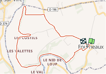
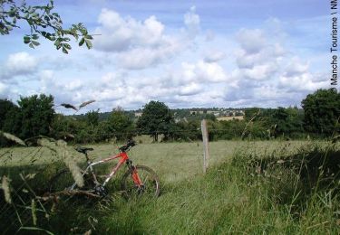
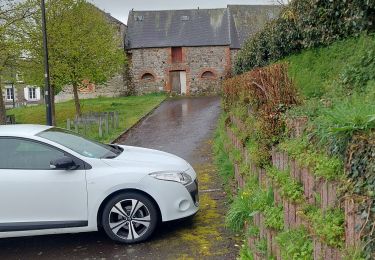
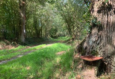
Tocht Mountainbike van 5,6 km beschikbaar op Normandië, Manche, Fourneaux. Deze tocht wordt voorgesteld door tracegps.
Beschrijving
Circuit proposé par la Communauté de Communes de Tessy sur Vire. Départ de l’église de Fourneaux. Retrouvez le descriptif et les commentaires du circuit sur le site de la Communauté de Communes de Tessy sur Vire.
Plaatsbepaling
Land:
France
Regio :
Normandië
Departement/Provincie :
Manche
Gemeente :
Fourneaux
Locatie:
Unknown
Vertrek:(Dec)
Vertrek:(UTM)
643733 ; 5425322 (30U) N.
Opmerkingen
Wandeltochten in de omgeving
![Tocht Stappen Condé-sur-Vire - Le rocher de Ham - Photo](https://media.geolcdn.com/t/375/260/8542ca5d-28d3-484e-89d2-e8c026fb9d47.jpg&format=jpg&maxdim=2)
![Stappen Stappen](https://static1.geolcdn.com/sitytour/trail-icons/101.png)
Le rocher de Ham
Stappen
Gemakkelijk
(1)
Condé-sur-Vire,
Normandië,
Manche,
France
![](/images/other/stat-length.png)
10,9 km | 13,4 km-effort
2h 24min
![](https://static1.geolcdn.com/siteimages/upload/files/16400158638029165_repeat_loop_refresh_sync_direction_icon.png)
Ja
![Tocht Stappen Condé-sur-Vire - Roches de ham - Photo](https://media.geolcdn.com/t/375/260/ext.jpg?maxdim=2&url=https%3A%2F%2Fservices.sitytrail.com%2FGeolivesWS%2FDownloadMedia.ashx%3FTrailID%3D267550%26Media%3Dfix__20140417152802.jpg)
![Stappen Stappen](https://static1.geolcdn.com/sitytour/trail-icons/101.png)
Roches de ham
Stappen
Gemakkelijk
(1)
Condé-sur-Vire,
Normandië,
Manche,
France
![](/images/other/stat-length.png)
11,1 km | 13,5 km-effort
2h 58min
![](https://static1.geolcdn.com/siteimages/upload/files/16400158638029165_repeat_loop_refresh_sync_direction_icon.png)
Ja
![Tocht Mountainbike Domjean - Au coeur de la vallée de la Vire - Photo](https://media.geolcdn.com/t/375/260/ext.jpg?maxdim=2&url=https%3A%2F%2Fservices.sitytrail.com%2FGeolivesWS%2FDownloadMedia.ashx%3FTrailID%3D109294%26Media%3D3496_1.jpg)
![Mountainbike Mountainbike](https://static1.geolcdn.com/sitytour/trail-icons/202.png)
Au coeur de la vallée de la Vire
Mountainbike
Moeilijk
(2)
Domjean,
Normandië,
Manche,
France
![](/images/other/stat-length.png)
32 km | 39 km-effort
4h 0min
![](https://static1.geolcdn.com/siteimages/upload/files/16400158638029165_repeat_loop_refresh_sync_direction_icon.png)
Ja
![Tocht Noords wandelen Tessy-Bocage - rando haras pont farcy - Photo](https://media.geolcdn.com/t/375/260/3415af69-7f2b-496f-a8fd-837c9e113cab.jpg&format=jpg&maxdim=2)
![Noords wandelen Noords wandelen](https://static1.geolcdn.com/sitytour/trail-icons/102.png)
rando haras pont farcy
Noords wandelen
Heel gemakkelijk
(1)
Tessy-Bocage,
Normandië,
Manche,
France
![](/images/other/stat-length.png)
9,9 km | 11,9 km-effort
2h 1min
![](https://static1.geolcdn.com/siteimages/upload/files/16400158638029165_repeat_loop_refresh_sync_direction_icon.png)
Neen
![Tocht Noords wandelen Gouvets - rando eleanore - Photo](https://media.geolcdn.com/t/375/260/ext.jpg?maxdim=2&url=https%3A%2F%2Fstatic1.geolcdn.com%2Fsiteimages%2Fupload%2Ffiles%2F1545311037marcheuse_200dpi.jpg)
![Noords wandelen Noords wandelen](https://static1.geolcdn.com/sitytour/trail-icons/102.png)
rando eleanore
Noords wandelen
Moeilijk
(1)
Gouvets,
Normandië,
Manche,
France
![](/images/other/stat-length.png)
11,1 km | 13,7 km-effort
2h 14min
![](https://static1.geolcdn.com/siteimages/upload/files/16400158638029165_repeat_loop_refresh_sync_direction_icon.png)
Ja
![Tocht Stappen Domjean - Rando gorge de la Vire - Photo](https://media.geolcdn.com/t/375/260/078dd238-3b4c-4f3c-9933-8f29f8ae0807.jpg&format=jpg&maxdim=2)
![Stappen Stappen](https://static1.geolcdn.com/sitytour/trail-icons/101.png)
Rando gorge de la Vire
Stappen
Gemakkelijk
Domjean,
Normandië,
Manche,
France
![](/images/other/stat-length.png)
35 km | 42 km-effort
10h 25min
![](https://static1.geolcdn.com/siteimages/upload/files/16400158638029165_repeat_loop_refresh_sync_direction_icon.png)
Ja
![Tocht Stappen Tessy-Bocage - Tessy-sur-Vire - C 13-V - Photo](https://media.geolcdn.com/t/375/260/ext.jpg?maxdim=2&url=https%3A%2F%2Fservices.sitytrail.com%2FGeolivesWS%2FDownloadMedia.ashx%3FTrailID%3D111302%26Media%3D6947_5.jpg)
![Stappen Stappen](https://static1.geolcdn.com/sitytour/trail-icons/101.png)
Tessy-sur-Vire - C 13-V
Stappen
Gemakkelijk
Tessy-Bocage,
Normandië,
Manche,
France
![](/images/other/stat-length.png)
3,4 km | 4,1 km-effort
1h 0min
![](https://static1.geolcdn.com/siteimages/upload/files/16400158638029165_repeat_loop_refresh_sync_direction_icon.png)
Ja
![Tocht Mountainbike Tessy-Bocage - Tessy-sur-Vire - C 13-II - Photo](https://media.geolcdn.com/t/375/260/ext.jpg?maxdim=2&url=https%3A%2F%2Fservices.sitytrail.com%2FGeolivesWS%2FDownloadMedia.ashx%3FTrailID%3D111296%26Media%3D6939_4.jpg)
![Mountainbike Mountainbike](https://static1.geolcdn.com/sitytour/trail-icons/202.png)
Tessy-sur-Vire - C 13-II
Mountainbike
Gemakkelijk
Tessy-Bocage,
Normandië,
Manche,
France
![](/images/other/stat-length.png)
8,8 km | 10,5 km-effort
1h 0min
![](https://static1.geolcdn.com/siteimages/upload/files/16400158638029165_repeat_loop_refresh_sync_direction_icon.png)
Ja
![Tocht Stappen Tessy-Bocage - Tessy-sur-Vire - C 13-II - Photo](https://media.geolcdn.com/t/375/260/ext.jpg?maxdim=2&url=https%3A%2F%2Fservices.sitytrail.com%2FGeolivesWS%2FDownloadMedia.ashx%3FTrailID%3D111295%26Media%3D6939_4.jpg)
![Stappen Stappen](https://static1.geolcdn.com/sitytour/trail-icons/101.png)
Tessy-sur-Vire - C 13-II
Stappen
Medium
Tessy-Bocage,
Normandië,
Manche,
France
![](/images/other/stat-length.png)
8,8 km | 10,5 km-effort
2h 15min
![](https://static1.geolcdn.com/siteimages/upload/files/16400158638029165_repeat_loop_refresh_sync_direction_icon.png)
Ja