![](/images/other/stat-length.png)
![Tocht Paard Villeneuve-sur-Lot - Saint-Germain, l'autre colline de Villeneuve-sur-lot - Pays de la vallée du Lot - Photo](https://media.geolcdn.com/t/1900/400/ext.pjpeg?maxdim=2&url=https%3A%2F%2Fservices.sitytrail.com%2FGeolivesWS%2FDownloadMedia.ashx%3FTrailID%3D111120%26Media%3D6460_1.jpg)
Saint-Germain, l'autre colline de Villeneuve-sur-lot - Pays de la vallée du Lot
tracegps
Gebruiker
![Lengte](/images/other/stat-length.png)
![Max. hoogte](https://static1.geolcdn.com/siteimages/upload/files/1508320355ic_sort_altitude_max_24dp.png)
![Positief hoogteverschil](https://static1.geolcdn.com/siteimages/upload/files/1508320355ic_sort_den_pos_24dp.png)
![Km-Effort](/images/other/stat-length.png)
![Min. hoogte](https://static1.geolcdn.com/siteimages/upload/files/1508320355ic_sort_altitude_min_24dp.png)
![Negatief hoogteverschil](https://static1.geolcdn.com/siteimages/upload/files/1508320355ic_sort_den_neg_24dp.png)
![Boucle](https://static1.geolcdn.com/siteimages/upload/files/16400158638029165_repeat_loop_refresh_sync_direction_icon.png)
![Paard](https://static1.geolcdn.com/sitytour/trail-icons/300.png)
1h45
Moeilijkheid : Medium
![Scan deze QR-code om de tocht te openen in de SityTrail-applicatie](https://capi.geolives.com/qq0zvz2zws4bq2lad0pu/sitytour/trails/111120/qr.png?size=200)
Gratisgps-wandelapplicatie
Over ons
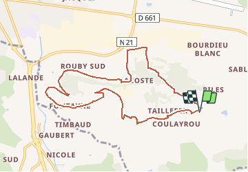
Tocht Paard van 10,2 km beschikbaar op Nieuw-Aquitanië, Lot-et-Garonne, Villeneuve-sur-Lot. Deze tocht wordt voorgesteld door tracegps.
Beschrijving
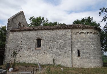
StGermain/StMartin Cne de Villeneuvesur Lot C.C. du Villeneuvois. Les pèlerins de St-Jacques marchent sur une partie de ce circuit venant du Puy-en-Velay, via Figeac et Rocamadour. Dans le relief accidenté, le regard porte loin vers la vallée du Lot. Téléchargez la fiche de cette randonnée sur le site du Tourisme du Lot et Garonne.
Plaatsbepaling
Opmerkingen
Wandeltochten in de omgeving
![Tocht Stappen Pujols - Cambes, un circuit autour d'une combe boisée - Pays de la vallée du Lot - Photo](https://media.geolcdn.com/t/375/260/ext.jpg?maxdim=2&url=https%3A%2F%2Fservices.sitytrail.com%2FGeolivesWS%2FDownloadMedia.ashx%3FTrailID%3D111067%26Media%3D6432_1.jpg)
![Stappen Stappen](https://static1.geolcdn.com/sitytour/trail-icons/101.png)
Stappen
![](/images/other/stat-length.png)
![](https://static1.geolcdn.com/siteimages/upload/files/16400158638029165_repeat_loop_refresh_sync_direction_icon.png)
![Tocht Stappen Hautefage-la-Tour - Bonneval, le circuit des trois églises - Pays de la vallée du Lot - Photo](https://media.geolcdn.com/t/375/260/ext.jpg?maxdim=2&url=https%3A%2F%2Fservices.sitytrail.com%2FGeolivesWS%2FDownloadMedia.ashx%3FTrailID%3D110835%26Media%3D6309_1.jpg)
![Stappen Stappen](https://static1.geolcdn.com/sitytour/trail-icons/101.png)
Stappen
![](/images/other/stat-length.png)
![](https://static1.geolcdn.com/siteimages/upload/files/16400158638029165_repeat_loop_refresh_sync_direction_icon.png)
![Tocht Te voet Hautefage-la-Tour - Saint-Thomas, par Saint-Just et Piquepoul - 10.6 km - Photo](https://media.geolcdn.com/t/375/260/0159e0b0-0768-4fb0-bf01-e950449d9ffd.jpeg&format=jpg&maxdim=2)
![Te voet Te voet](https://static1.geolcdn.com/sitytour/trail-icons/100.png)
Te voet
![](/images/other/stat-length.png)
![](https://static1.geolcdn.com/siteimages/upload/files/16400158638029165_repeat_loop_refresh_sync_direction_icon.png)
![Tocht Te voet Saint-Antoine-de-Ficalba - Bonneval, le circuit des trois églises - 10,7km - Photo](https://media.geolcdn.com/t/375/260/0159e0b0-0768-4fb0-bf01-e950449d9ffd.jpeg&format=jpg&maxdim=2)
![Te voet Te voet](https://static1.geolcdn.com/sitytour/trail-icons/100.png)
Te voet
![](/images/other/stat-length.png)
![](https://static1.geolcdn.com/siteimages/upload/files/16400158638029165_repeat_loop_refresh_sync_direction_icon.png)
![Tocht Te voet Penne-d'Agenais - Penne-d’Agenais, vers le château de Noaillac - 13,2km - Photo](https://media.geolcdn.com/t/375/260/ab1b4457-776f-4293-97bf-e8d308314e23.jpeg&format=jpg&maxdim=2)
![Te voet Te voet](https://static1.geolcdn.com/sitytour/trail-icons/100.png)
Te voet
![](/images/other/stat-length.png)
![](https://static1.geolcdn.com/siteimages/upload/files/16400158638029165_repeat_loop_refresh_sync_direction_icon.png)
![Tocht Mountainbike Penne-d'Agenais - 8142359 track 1522706785 672 - Photo](https://media.geolcdn.com/t/375/260/ext.jpg?maxdim=2&url=https%3A%2F%2Fstatic1.geolcdn.com%2Fsiteimages%2Fupload%2Ffiles%2F1524743154velo.jpg)
![Mountainbike Mountainbike](https://static1.geolcdn.com/sitytour/trail-icons/202.png)
Mountainbike
![](/images/other/stat-length.png)
![](https://static1.geolcdn.com/siteimages/upload/files/16400158638029165_repeat_loop_refresh_sync_direction_icon.png)
![Tocht Fiets Villeneuve-sur-Lot - de Villeneuve sur Lot à Moissac en passant par Aiguillon - Photo](https://media.geolcdn.com/t/375/260/ext.jpg?maxdim=2&url=https%3A%2F%2Fservices.sitytrail.com%2FGeolivesWS%2FDownloadMedia.ashx%3FTrailID%3D588391%26Media%3Df4638f96-87eb-466a-9d9d-69a168ebcbb2.JPG)
![Fiets Fiets](https://static1.geolcdn.com/sitytour/trail-icons/200.png)
Fiets
![](/images/other/stat-length.png)
![](https://static1.geolcdn.com/siteimages/upload/files/16400158638029165_repeat_loop_refresh_sync_direction_icon.png)
![Tocht Stappen Pujols - Cambes Pujols - Photo](https://media.geolcdn.com/t/375/260/e50c9e7e-2a48-47aa-8b6d-475985980a6b.jpg&format=jpg&maxdim=2)
![Stappen Stappen](https://static1.geolcdn.com/sitytour/trail-icons/101.png)
Stappen
![](/images/other/stat-length.png)
![](https://static1.geolcdn.com/siteimages/upload/files/16400158638029165_repeat_loop_refresh_sync_direction_icon.png)
![Tocht Te voet Auradou - Penne-d’Agenais, Auradou, dans les coteaux nord du Pays de Serres - 23km - Photo](https://media.geolcdn.com/t/375/260/ext.jpg?maxdim=2&url=https%3A%2F%2Fstatic1.geolcdn.com%2Fsiteimages%2Fupload%2Ffiles%2F1545311037marcheuse_200dpi.jpg)
![Te voet Te voet](https://static1.geolcdn.com/sitytour/trail-icons/100.png)
Te voet
![](/images/other/stat-length.png)
![](https://static1.geolcdn.com/siteimages/upload/files/16400158638029165_repeat_loop_refresh_sync_direction_icon.png)