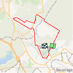
![](/images/other/stat-length.png)
![Tocht Mountainbike Raismes - Circuits de l'Etoile de Cernay et des Bruyères - Raismes. - Photo](https://media.geolcdn.com/t/1900/400/ext.pjpeg?maxdim=2&url=https%3A%2F%2Fservices.sitytrail.com%2FGeolivesWS%2FDownloadMedia.ashx%3FTrailID%3D111008%26Media%3D6389_6.jpg)
Circuits de l'Etoile de Cernay et des Bruyères - Raismes.
tracegps
Gebruiker
![Lengte](/images/other/stat-length.png)
![Max. hoogte](https://static1.geolcdn.com/siteimages/upload/files/1508320355ic_sort_altitude_max_24dp.png)
![Positief hoogteverschil](https://static1.geolcdn.com/siteimages/upload/files/1508320355ic_sort_den_pos_24dp.png)
![Km-Effort](/images/other/stat-length.png)
![Min. hoogte](https://static1.geolcdn.com/siteimages/upload/files/1508320355ic_sort_altitude_min_24dp.png)
![Negatief hoogteverschil](https://static1.geolcdn.com/siteimages/upload/files/1508320355ic_sort_den_neg_24dp.png)
![Boucle](https://static1.geolcdn.com/siteimages/upload/files/16400158638029165_repeat_loop_refresh_sync_direction_icon.png)
![Mountainbike](https://static1.geolcdn.com/sitytour/trail-icons/202.png)
1h30
Moeilijkheid : Medium
![Scan deze QR-code om de tocht te openen in de SityTrail-applicatie](https://capi.geolives.com/qq0zvz2zws4bq2lad0pu/sitytour/trails/111008/qr.png?size=200)
Gratisgps-wandelapplicatie
Over ons
Tocht Mountainbike van 13,3 km beschikbaar op Hauts-de-France, Noorderdepartement, Raismes. Deze tocht wordt voorgesteld door tracegps.
Beschrijving
Circuit proposé par le Comité Départemental du Tourisme du Nord et la Maison de la Forêt. Fiche n° 12 de la pochette «Les circuits VTT du Nord pour la famille et les sportifs». Départ du parking de la Maison de la forêt et de la base de loisirs. Circuits faciles mais chemins forestiers parfois boueux en période de pluie. Vous pédalerez au sein de ce massif chargé d’histoire, au 2/3 replanté après la Grande Guerre et aux arbres majestueux (à voir : l’allée des hêtres). A noter d’avril à septembre : location de VTT à la base de loisirs de Raismes ; Maison de la Forêt ouverte au public l’après midi les dimanches, mercredis, jours fériés et jours de vacances scolaires. Retrouvez ce circuit sur le site du Comité Départemental du Tourisme du Nord.
Plaatsbepaling
Opmerkingen
Wandeltochten in de omgeving
![Tocht Stappen Raismes - Circuit du Terril de Sabatier - Photo](https://media.geolcdn.com/t/375/260/ext.jpg?maxdim=2&url=https%3A%2F%2Fservices.sitytrail.com%2FGeolivesWS%2FDownloadMedia.ashx%3FTrailID%3D479716%26Media%3D781031eb-7ab3-4c80-8a0c-0836d5a81ce2.JPG)
![Stappen Stappen](https://static1.geolcdn.com/sitytour/trail-icons/101.png)
Stappen
![](/images/other/stat-length.png)
![](https://static1.geolcdn.com/siteimages/upload/files/16400158638029165_repeat_loop_refresh_sync_direction_icon.png)
![Tocht Stappen Wallers - Mare à Goriau - Photo](https://media.geolcdn.com/t/375/260/299e6191-18b5-438f-9d95-49f66a90f690.jpg&format=jpg&maxdim=2)
![Stappen Stappen](https://static1.geolcdn.com/sitytour/trail-icons/101.png)
Stappen
![](/images/other/stat-length.png)
![](https://static1.geolcdn.com/siteimages/upload/files/16400158638029165_repeat_loop_refresh_sync_direction_icon.png)
![Tocht Stappen Raismes - Mare à Goriaux - Photo](https://media.geolcdn.com/t/375/260/cb4184f6-3666-47fb-a89a-0644abab2b32.jpg&format=jpg&maxdim=2)
![Stappen Stappen](https://static1.geolcdn.com/sitytour/trail-icons/101.png)
Stappen
![](/images/other/stat-length.png)
![](https://static1.geolcdn.com/siteimages/upload/files/16400158638029165_repeat_loop_refresh_sync_direction_icon.png)
![Tocht Stappen Raismes - Terril du lavoir Rousseau - Photo](https://media.geolcdn.com/t/375/260/55636772-211b-4a0e-95d1-d18ad30169e0.jpg&format=jpg&maxdim=2)
![Stappen Stappen](https://static1.geolcdn.com/sitytour/trail-icons/101.png)
Stappen
![](/images/other/stat-length.png)
![](https://static1.geolcdn.com/siteimages/upload/files/16400158638029165_repeat_loop_refresh_sync_direction_icon.png)
![Tocht Stappen Saint-Amand-les-Eaux - terril vicoigne - Photo](https://media.geolcdn.com/t/375/260/d8552856-5959-4bc8-a6d2-93f721ca17ec.jpg&format=jpg&maxdim=2)
![Stappen Stappen](https://static1.geolcdn.com/sitytour/trail-icons/101.png)
Stappen
![](/images/other/stat-length.png)
![](https://static1.geolcdn.com/siteimages/upload/files/16400158638029165_repeat_loop_refresh_sync_direction_icon.png)
![Tocht Stappen Raismes - terril du lavoir rousseau - Photo](https://media.geolcdn.com/t/375/260/2a750bf1-1f0f-4ec6-9f4d-4d916d2a14af.jpg&format=jpg&maxdim=2)
![Stappen Stappen](https://static1.geolcdn.com/sitytour/trail-icons/101.png)
Stappen
![](/images/other/stat-length.png)
![](https://static1.geolcdn.com/siteimages/upload/files/16400158638029165_repeat_loop_refresh_sync_direction_icon.png)
![Tocht Stappen Saint-Amand-les-Eaux - notre dame d'amour(NDA), propose par VDN - Photo](https://media.geolcdn.com/t/375/260/630cd120-0ef0-4a83-86e7-91e6331d9f35.jpg&format=jpg&maxdim=2)
![Stappen Stappen](https://static1.geolcdn.com/sitytour/trail-icons/101.png)
Stappen
![](/images/other/stat-length.png)
![](https://static1.geolcdn.com/siteimages/upload/files/16400158638029165_repeat_loop_refresh_sync_direction_icon.png)
![Tocht Stappen Raismes - variante de la course des terrils - Photo](https://media.geolcdn.com/t/375/260/f1af6116-6469-445b-a358-4f5a4f22ced7.jpg&format=jpg&maxdim=2)
![Stappen Stappen](https://static1.geolcdn.com/sitytour/trail-icons/101.png)
Stappen
![](/images/other/stat-length.png)
![](https://static1.geolcdn.com/siteimages/upload/files/16400158638029165_repeat_loop_refresh_sync_direction_icon.png)
![Tocht Stappen Wallers - Mare goraux - Photo](https://media.geolcdn.com/t/375/260/82eaa7c8-ae6a-4094-92a3-48d31e49731d.jpg&format=jpg&maxdim=2)
![Stappen Stappen](https://static1.geolcdn.com/sitytour/trail-icons/101.png)
Stappen
![](/images/other/stat-length.png)
![](https://static1.geolcdn.com/siteimages/upload/files/16400158638029165_repeat_loop_refresh_sync_direction_icon.png)