![](/images/other/stat-length.png)
![Tocht Mountainbike Mézin - De Mézin, la Médiévale à Poudenas l'Italienne - Pays d'Albret - Photo](https://media.geolcdn.com/t/1900/400/ext.pjpeg?maxdim=2&url=https%3A%2F%2Fservices.sitytrail.com%2FGeolivesWS%2FDownloadMedia.ashx%3FTrailID%3D110795%26Media%3D6293_1.jpg)
De Mézin, la Médiévale à Poudenas l'Italienne - Pays d'Albret
tracegps
Gebruiker
![Lengte](/images/other/stat-length.png)
![Max. hoogte](https://static1.geolcdn.com/siteimages/upload/files/1508320355ic_sort_altitude_max_24dp.png)
![Positief hoogteverschil](https://static1.geolcdn.com/siteimages/upload/files/1508320355ic_sort_den_pos_24dp.png)
![Km-Effort](/images/other/stat-length.png)
![Min. hoogte](https://static1.geolcdn.com/siteimages/upload/files/1508320355ic_sort_altitude_min_24dp.png)
![Negatief hoogteverschil](https://static1.geolcdn.com/siteimages/upload/files/1508320355ic_sort_den_neg_24dp.png)
![Boucle](https://static1.geolcdn.com/siteimages/upload/files/16400158638029165_repeat_loop_refresh_sync_direction_icon.png)
![Mountainbike](https://static1.geolcdn.com/sitytour/trail-icons/202.png)
1h45
Moeilijkheid : Medium
![Scan deze QR-code om de tocht te openen in de SityTrail-applicatie](https://capi.geolives.com/qq0zvz2zws4bq2lad0pu/sitytour/trails/110795/qr.png?size=200)
Gratisgps-wandelapplicatie
Over ons
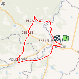
Tocht Mountainbike van 14,3 km beschikbaar op Nieuw-Aquitanië, Lot-et-Garonne, Mézin. Deze tocht wordt voorgesteld door tracegps.
Beschrijving
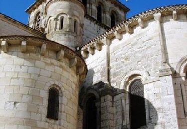
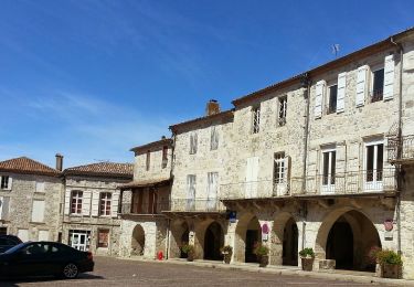
Mézin / Poudenas Communauté de Communes du Mézinais. Sur les pas des pèlerins jacquaires, un circuit autour de la Gélise pour visiter Mézin la Médiévale à l’église fortifiée, et rejoindre Poudenas, la belle Italienne épanouie sous les terrasses de son château. Téléchargez la fiche de cette randonnée sur le site du Tourisme du Lot et Garonne. Extrait de la Balade insolite de Mézin par CDT47
Plaatsbepaling
Opmerkingen
Wandeltochten in de omgeving
![Tocht Mountainbike Mézin - Mézin, des jardins paysagers à la table d'orientation - Pays d'Albret - Photo](https://media.geolcdn.com/t/375/260/ext.jpg?maxdim=2&url=https%3A%2F%2Fservices.sitytrail.com%2FGeolivesWS%2FDownloadMedia.ashx%3FTrailID%3D110798%26Media%3D6294_1.jpg)
![Mountainbike Mountainbike](https://static1.geolcdn.com/sitytour/trail-icons/202.png)
Mountainbike
![](/images/other/stat-length.png)
![](https://static1.geolcdn.com/siteimages/upload/files/16400158638029165_repeat_loop_refresh_sync_direction_icon.png)
![Tocht Te voet Poudenas - Poudenas, une ambiance de Toscane 10.8 km - Photo](https://media.geolcdn.com/t/375/260/ef3687dd-33b2-428d-9c76-911af79325b2.jpeg&format=jpg&maxdim=2)
![Te voet Te voet](https://static1.geolcdn.com/sitytour/trail-icons/100.png)
Te voet
![](/images/other/stat-length.png)
![](https://static1.geolcdn.com/siteimages/upload/files/16400158638029165_repeat_loop_refresh_sync_direction_icon.png)
![Tocht Te voet Poudenas - Poudenas, une ambiance de Toscane variante 7.8 km - Photo](https://media.geolcdn.com/t/375/260/ef3687dd-33b2-428d-9c76-911af79325b2.jpeg&format=jpg&maxdim=2)
![Te voet Te voet](https://static1.geolcdn.com/sitytour/trail-icons/100.png)
Te voet
![](/images/other/stat-length.png)
![](https://static1.geolcdn.com/siteimages/upload/files/16400158638029165_repeat_loop_refresh_sync_direction_icon.png)
![Tocht Te voet Mézin - De Mézin à Villeneuve-de-Mézin, sur la route de Compostelle 16.6 km - Photo](https://media.geolcdn.com/t/375/260/ae5ee892-264d-47ca-b970-07ea0e883592.jpeg&format=jpg&maxdim=2)
![Te voet Te voet](https://static1.geolcdn.com/sitytour/trail-icons/100.png)
Te voet
![](/images/other/stat-length.png)
![](https://static1.geolcdn.com/siteimages/upload/files/16400158638029165_repeat_loop_refresh_sync_direction_icon.png)
![Tocht Te voet Poudenas - De Mézin, la Médiévale à Poudenas, l'Italienne 14.3 km - Photo](https://media.geolcdn.com/t/375/260/4931e991-4f88-4037-bc7e-658247d6e79b.jpeg&format=jpg&maxdim=2)
![Te voet Te voet](https://static1.geolcdn.com/sitytour/trail-icons/100.png)
Te voet
![](/images/other/stat-length.png)
![](https://static1.geolcdn.com/siteimages/upload/files/16400158638029165_repeat_loop_refresh_sync_direction_icon.png)
![Tocht Te voet Mézin - Mézin, des jardins paysagers à la table d'orientation 4.8 km - Photo](https://media.geolcdn.com/t/375/260/ca3ca46d-f8e9-498b-bff7-554e5a603f77.jpeg&format=jpg&maxdim=2)
![Te voet Te voet](https://static1.geolcdn.com/sitytour/trail-icons/100.png)
Te voet
![](/images/other/stat-length.png)
![](https://static1.geolcdn.com/siteimages/upload/files/16400158638029165_repeat_loop_refresh_sync_direction_icon.png)
![Tocht Te voet Mézin - Mézin, des jardins paysagers à la table d'orientation variante 3.7 km km - Photo](https://media.geolcdn.com/t/375/260/ae5ee892-264d-47ca-b970-07ea0e883592.jpeg&format=jpg&maxdim=2)
![Te voet Te voet](https://static1.geolcdn.com/sitytour/trail-icons/100.png)
Te voet
![](/images/other/stat-length.png)
![](https://static1.geolcdn.com/siteimages/upload/files/16400158638029165_repeat_loop_refresh_sync_direction_icon.png)
![Tocht Te voet Lannes - De Lannes à Mézin, le parfum de l'Armagnac-Ténarèze 9.6 km - Photo](https://media.geolcdn.com/t/375/260/bf01d176-dfbc-4f74-9a32-be82b3416151.jpeg&format=jpg&maxdim=2)
![Te voet Te voet](https://static1.geolcdn.com/sitytour/trail-icons/100.png)
Te voet
![](/images/other/stat-length.png)
![](https://static1.geolcdn.com/siteimages/upload/files/16400158638029165_repeat_loop_refresh_sync_direction_icon.png)
![Tocht Stappen Réaup-Lisse - Reaup mounicar - Photo](https://media.geolcdn.com/t/375/260/ac4c919e-74de-4535-9d56-5ca381ca3549.jpg&format=jpg&maxdim=2)
![Stappen Stappen](https://static1.geolcdn.com/sitytour/trail-icons/101.png)
Stappen
![](/images/other/stat-length.png)
![](https://static1.geolcdn.com/siteimages/upload/files/16400158638029165_repeat_loop_refresh_sync_direction_icon.png)
Quelques passages sablonneux difficiles. Sinon très beau parcours !