![](/images/other/stat-length.png)
![Tocht Fiets Broglie - Boucle des 3 Maréchaux - Broglie - Photo](https://media.geolcdn.com/t/1900/400/ext.pjpeg?maxdim=2&url=https%3A%2F%2Fservices.sitytrail.com%2FGeolivesWS%2FDownloadMedia.ashx%3FTrailID%3D110423%26Media%3D5899_1.jpg)
Boucle des 3 Maréchaux - Broglie
tracegps
Gebruiker
![Lengte](/images/other/stat-length.png)
Lengte
18,5 km
![Max. hoogte](https://static1.geolcdn.com/siteimages/upload/files/1508320355ic_sort_altitude_max_24dp.png)
Max. hoogte
207 m
![Positief hoogteverschil](https://static1.geolcdn.com/siteimages/upload/files/1508320355ic_sort_den_pos_24dp.png)
Positief hoogteverschil
144 m
![Km-Effort](/images/other/stat-length.png)
Km-Effort
20 km
![Min. hoogte](https://static1.geolcdn.com/siteimages/upload/files/1508320355ic_sort_altitude_min_24dp.png)
Min. hoogte
130 m
![Negatief hoogteverschil](https://static1.geolcdn.com/siteimages/upload/files/1508320355ic_sort_den_neg_24dp.png)
Negatief hoogteverschil
142 m
![Boucle](https://static1.geolcdn.com/siteimages/upload/files/16400158638029165_repeat_loop_refresh_sync_direction_icon.png)
Boucle
Ja
Datum van aanmaak :
2014-12-10 00:00:00.0
Laatste wijziging :
2014-12-10 00:00:00.0
![Fiets](https://static1.geolcdn.com/sitytour/trail-icons/200.png)
1h15
Moeilijkheid : Medium
![Scan deze QR-code om de tocht te openen in de SityTrail-applicatie](https://capi.geolives.com/qq0zvz2zws4bq2lad0pu/sitytour/trails/110423/qr.png?size=200)
Gratisgps-wandelapplicatie
Over ons
Tocht Fiets van 18,5 km beschikbaar op Normandië, Eure, Broglie. Deze tocht wordt voorgesteld door tracegps.
Beschrijving
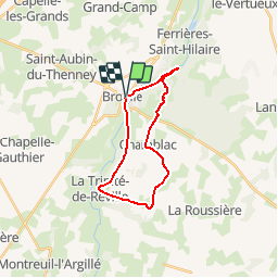
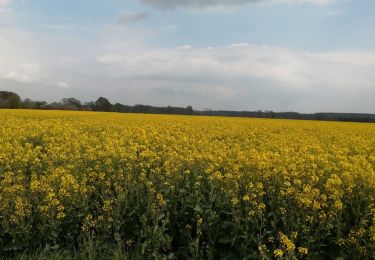
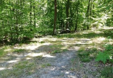
Circuit proposé par la Communauté de Communes du canton de Broglie. Départ du parking du jardin aquatique de Broglie. Ce circuit a été numérisé par les randonneurs du CODEPEM. Merci à Jean-Marie.
Plaatsbepaling
Land:
France
Regio :
Normandië
Departement/Provincie :
Eure
Gemeente :
Broglie
Locatie:
Unknown
Vertrek:(Dec)
Vertrek:(UTM)
319438 ; 5431300 (31U) N.
Opmerkingen
Wandeltochten in de omgeving
![Tocht Stappen Ferrières-Saint-Hilaire - Ferrières St Hilaire - Photo](https://media.geolcdn.com/t/375/260/ext.jpg?maxdim=2&url=https%3A%2F%2Fstatic1.geolcdn.com%2Fsiteimages%2Fupload%2Ffiles%2F1553511878bg_sport_marche.png)
![Stappen Stappen](https://static1.geolcdn.com/sitytour/trail-icons/101.png)
Ferrières St Hilaire
Stappen
Heel gemakkelijk
(1)
Ferrières-Saint-Hilaire,
Normandië,
Eure,
France
![](/images/other/stat-length.png)
9,4 km | 11,3 km-effort
2h 25min
![](https://static1.geolcdn.com/siteimages/upload/files/16400158638029165_repeat_loop_refresh_sync_direction_icon.png)
Ja
![Tocht Stappen Chamblac - Circuit de Bonneville - Chamblac - Photo](https://media.geolcdn.com/t/375/260/ext.jpg?maxdim=2&url=https%3A%2F%2Fservices.sitytrail.com%2FGeolivesWS%2FDownloadMedia.ashx%3FTrailID%3D110471%26Media%3D5987_6.jpg)
![Stappen Stappen](https://static1.geolcdn.com/sitytour/trail-icons/101.png)
Circuit de Bonneville - Chamblac
Stappen
Medium
Chamblac,
Normandië,
Eure,
France
![](/images/other/stat-length.png)
11,2 km | 12 km-effort
2h 45min
![](https://static1.geolcdn.com/siteimages/upload/files/16400158638029165_repeat_loop_refresh_sync_direction_icon.png)
Ja
![Tocht Stappen Broglie - Circuit du Prieuré - Broglie - Photo](https://media.geolcdn.com/t/375/260/ext.jpg?maxdim=2&url=https%3A%2F%2Fservices.sitytrail.com%2FGeolivesWS%2FDownloadMedia.ashx%3FTrailID%3D110322%26Media%3D5753_6.jpg)
![Stappen Stappen](https://static1.geolcdn.com/sitytour/trail-icons/101.png)
Circuit du Prieuré - Broglie
Stappen
Moeilijk
(1)
Broglie,
Normandië,
Eure,
France
![](/images/other/stat-length.png)
13,2 km | 14,9 km-effort
3h 19min
![](https://static1.geolcdn.com/siteimages/upload/files/16400158638029165_repeat_loop_refresh_sync_direction_icon.png)
Ja
![Tocht sport Grand-Camp - Grand camps - Photo](https://media.geolcdn.com/t/375/260/996f208c-f7d6-49a4-a23f-49d061311922.jpg&format=jpg&maxdim=2)
Grand camps
sport
Heel gemakkelijk
Grand-Camp,
Normandië,
Eure,
France
![](/images/other/stat-length.png)
5,3 km | 6 km-effort
Onbekend
![](https://static1.geolcdn.com/siteimages/upload/files/16400158638029165_repeat_loop_refresh_sync_direction_icon.png)
Neen
![Tocht Stappen Saint-Aubin-du-Thenney - boucle de St Aubin - Photo](https://media.geolcdn.com/t/375/260/22b229be-1ffc-465d-84c7-a658d5646130.jpg&format=jpg&maxdim=2)
![Stappen Stappen](https://static1.geolcdn.com/sitytour/trail-icons/101.png)
boucle de St Aubin
Stappen
Gemakkelijk
Saint-Aubin-du-Thenney,
Normandië,
Eure,
France
![](/images/other/stat-length.png)
5,2 km | 5,7 km-effort
1h 1min
![](https://static1.geolcdn.com/siteimages/upload/files/16400158638029165_repeat_loop_refresh_sync_direction_icon.png)
Ja
![Tocht Stappen Chamblac - Le Chamblac - Photo](https://media.geolcdn.com/t/375/260/2549477f-7466-4324-874c-e1e7cc721696.jpg&format=jpg&maxdim=2)
![Stappen Stappen](https://static1.geolcdn.com/sitytour/trail-icons/101.png)
Le Chamblac
Stappen
Gemakkelijk
Chamblac,
Normandië,
Eure,
France
![](/images/other/stat-length.png)
9,1 km | 9,7 km-effort
1h 52min
![](https://static1.geolcdn.com/siteimages/upload/files/16400158638029165_repeat_loop_refresh_sync_direction_icon.png)
Ja
![Tocht Stappen Broglie - Broglie - Photo](https://media.geolcdn.com/t/375/260/3c4d0b1a-62db-4850-83e8-af0ad4e2bb58.jpg&format=jpg&maxdim=2)
![Stappen Stappen](https://static1.geolcdn.com/sitytour/trail-icons/101.png)
![Tocht Stappen Grand-Camp - autour de Grand camp 2 - Photo](https://media.geolcdn.com/t/375/260/ed47d369-406e-47c8-b3ea-bf2f6cb0968d.jpg&format=jpg&maxdim=2)
![Stappen Stappen](https://static1.geolcdn.com/sitytour/trail-icons/101.png)
autour de Grand camp 2
Stappen
Heel gemakkelijk
Grand-Camp,
Normandië,
Eure,
France
![](/images/other/stat-length.png)
5,9 km | 6,4 km-effort
1h 18min
![](https://static1.geolcdn.com/siteimages/upload/files/16400158638029165_repeat_loop_refresh_sync_direction_icon.png)
Ja
![Tocht Stappen Chamblac - Chamblac - Photo](https://media.geolcdn.com/t/375/260/cd9e6435-34fa-4405-9f0e-e1f7b93da745.jpg&format=jpg&maxdim=2)
![Stappen Stappen](https://static1.geolcdn.com/sitytour/trail-icons/101.png)
Chamblac
Stappen
Heel gemakkelijk
Chamblac,
Normandië,
Eure,
France
![](/images/other/stat-length.png)
7,8 km | 8,3 km-effort
1h 36min
![](https://static1.geolcdn.com/siteimages/upload/files/16400158638029165_repeat_loop_refresh_sync_direction_icon.png)
Ja