![](/images/other/stat-length.png)
![Tocht Stappen Coaraze - Rocca Spavierra - Photo](https://media.geolcdn.com/t/1900/400/ext.pjpeg?maxdim=2&url=https%3A%2F%2Fstatic1.geolcdn.com%2Fsiteimages%2Fupload%2Ffiles%2F1553511878bg_sport_marche.png)
Rocca Spavierra
franquen
Gebruiker
![Lengte](/images/other/stat-length.png)
Lengte
11,6 km
![Max. hoogte](https://static1.geolcdn.com/siteimages/upload/files/1508320355ic_sort_altitude_max_24dp.png)
Max. hoogte
1096 m
![Positief hoogteverschil](https://static1.geolcdn.com/siteimages/upload/files/1508320355ic_sort_den_pos_24dp.png)
Positief hoogteverschil
595 m
![Km-Effort](/images/other/stat-length.png)
Km-Effort
19,6 km
![Min. hoogte](https://static1.geolcdn.com/siteimages/upload/files/1508320355ic_sort_altitude_min_24dp.png)
Min. hoogte
614 m
![Negatief hoogteverschil](https://static1.geolcdn.com/siteimages/upload/files/1508320355ic_sort_den_neg_24dp.png)
Negatief hoogteverschil
597 m
![Boucle](https://static1.geolcdn.com/siteimages/upload/files/16400158638029165_repeat_loop_refresh_sync_direction_icon.png)
Boucle
Ja
Datum van aanmaak :
2019-05-06 11:07:28.857
Laatste wijziging :
2019-05-06 11:07:28.857
![Stappen](https://static1.geolcdn.com/sitytour/trail-icons/101.png)
4h06
Moeilijkheid : Medium
![Scan deze QR-code om de tocht te openen in de SityTrail-applicatie](https://capi.geolives.com/qq0zvz2zws4bq2lad0pu/sitytour/trails/1103613/qr.png?size=200)
Gratisgps-wandelapplicatie
Over ons
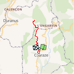
Tocht Stappen van 11,6 km beschikbaar op Provence-Alpes-Côte d'Azur, Alpes-Maritimes, Coaraze. Deze tocht wordt voorgesteld door franquen.
Beschrijving
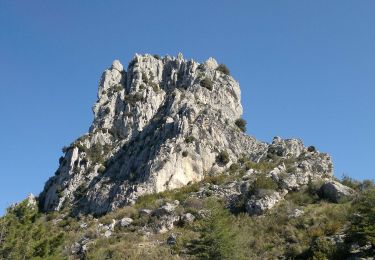
Magnifique rando avec un super point de vue. bâtons conseillés. Possibilité de faire une boucle par la pointe de Serena
Plaatsbepaling
Land:
France
Regio :
Provence-Alpes-Côte d'Azur
Departement/Provincie :
Alpes-Maritimes
Gemeente :
Coaraze
Locatie:
Unknown
Vertrek:(Dec)
Vertrek:(UTM)
362843 ; 4858309 (32T) N.
Opmerkingen
Wandeltochten in de omgeving
![Tocht Te voet Coaraze - Rocca Sparvièra - Photo](https://media.geolcdn.com/t/375/260/b70c2ec2-277e-4b66-a927-a7ae11b9ea3a.jpeg&format=jpg&maxdim=2)
![Te voet Te voet](https://static1.geolcdn.com/sitytour/trail-icons/100.png)
Rocca Sparvièra
Te voet
Gemakkelijk
Coaraze,
Provence-Alpes-Côte d'Azur,
Alpes-Maritimes,
France
![](/images/other/stat-length.png)
10,5 km | 17,6 km-effort
3h 59min
![](https://static1.geolcdn.com/siteimages/upload/files/16400158638029165_repeat_loop_refresh_sync_direction_icon.png)
Ja
![Tocht Te voet Utelle - Gorges de la Vésubie - Photo](https://media.geolcdn.com/t/375/260/0a667b03-3170-487d-a7f5-45b846bd9fdf.jpeg&format=jpg&maxdim=2)
![Te voet Te voet](https://static1.geolcdn.com/sitytour/trail-icons/100.png)
Gorges de la Vésubie
Te voet
Medium
(1)
Utelle,
Provence-Alpes-Côte d'Azur,
Alpes-Maritimes,
France
![](/images/other/stat-length.png)
14,6 km | 27 km-effort
6h 11min
![](https://static1.geolcdn.com/siteimages/upload/files/16400158638029165_repeat_loop_refresh_sync_direction_icon.png)
Ja
![Tocht Stappen Duranus - Rocca Sparviera Rocca Siera - Photo](https://media.geolcdn.com/t/375/260/cfa7ac61-c812-43a1-a04c-577e01c4a8ee.jpg&format=jpg&maxdim=2)
![Stappen Stappen](https://static1.geolcdn.com/sitytour/trail-icons/101.png)
Rocca Sparviera Rocca Siera
Stappen
Zeer moeilijk
Duranus,
Provence-Alpes-Côte d'Azur,
Alpes-Maritimes,
France
![](/images/other/stat-length.png)
16 km | 28 km-effort
6h 18min
![](https://static1.geolcdn.com/siteimages/upload/files/16400158638029165_repeat_loop_refresh_sync_direction_icon.png)
Ja
![Tocht Stappen L'Escarène - L’Escarene - Photo](https://media.geolcdn.com/t/375/260/471a6d65-ba9a-4a94-ae56-e041c5f1c486.jpg&format=jpg&maxdim=2)
![Stappen Stappen](https://static1.geolcdn.com/sitytour/trail-icons/101.png)
L’Escarene
Stappen
Gemakkelijk
L'Escarène,
Provence-Alpes-Côte d'Azur,
Alpes-Maritimes,
France
![](/images/other/stat-length.png)
10,1 km | 13,9 km-effort
4h 39min
![](https://static1.geolcdn.com/siteimages/upload/files/16400158638029165_repeat_loop_refresh_sync_direction_icon.png)
Ja
![Tocht Stappen Utelle - Cros d Utelle chapelle St Antoine - Photo](https://media.geolcdn.com/t/375/260/ccd5b578-c9f1-437b-9e91-d8a2d45b6420.jpg&format=jpg&maxdim=2)
![Stappen Stappen](https://static1.geolcdn.com/sitytour/trail-icons/101.png)
Cros d Utelle chapelle St Antoine
Stappen
Moeilijk
Utelle,
Provence-Alpes-Côte d'Azur,
Alpes-Maritimes,
France
![](/images/other/stat-length.png)
7,5 km | 13,7 km-effort
4h 6min
![](https://static1.geolcdn.com/siteimages/upload/files/16400158638029165_repeat_loop_refresh_sync_direction_icon.png)
Ja
![Stappen Stappen](https://static1.geolcdn.com/sitytour/trail-icons/101.png)
L'Escarène - Baisse de Bussia - Col de Savel - Chapelle Bon Coeur - Lucéram
Stappen
Medium
L'Escarène,
Provence-Alpes-Côte d'Azur,
Alpes-Maritimes,
France
![](/images/other/stat-length.png)
18,7 km | 28 km-effort
5h 16min
![](https://static1.geolcdn.com/siteimages/upload/files/16400158638029165_repeat_loop_refresh_sync_direction_icon.png)
Neen
![Tocht Stappen Levens - Crête du Férion 1412m 17-04-22 - Photo](https://media.geolcdn.com/t/375/260/d630ef2c-0149-421b-9b71-c0805c57034c.jpg&format=jpg&maxdim=2)
![Stappen Stappen](https://static1.geolcdn.com/sitytour/trail-icons/101.png)
Crête du Férion 1412m 17-04-22
Stappen
Medium
Levens,
Provence-Alpes-Côte d'Azur,
Alpes-Maritimes,
France
![](/images/other/stat-length.png)
12 km | 22 km-effort
4h 30min
![](https://static1.geolcdn.com/siteimages/upload/files/16400158638029165_repeat_loop_refresh_sync_direction_icon.png)
Ja
![Tocht Te voet Levens - Crête du Férion - Photo](https://media.geolcdn.com/t/375/260/d2999666-b0d9-4a97-b6d4-103e7aa801ec.jpeg&format=jpg&maxdim=2)
![Te voet Te voet](https://static1.geolcdn.com/sitytour/trail-icons/100.png)
Crête du Férion
Te voet
Medium
Levens,
Provence-Alpes-Côte d'Azur,
Alpes-Maritimes,
France
![](/images/other/stat-length.png)
13 km | 24 km-effort
5h 26min
![](https://static1.geolcdn.com/siteimages/upload/files/16400158638029165_repeat_loop_refresh_sync_direction_icon.png)
Ja
![Tocht Te voet Duranus - Mine de l'Eguisse - Photo](https://media.geolcdn.com/t/375/260/2b5a1d64-7b66-4e1b-b474-6ca73ff09bc3.jpeg&format=jpg&maxdim=2)
![Te voet Te voet](https://static1.geolcdn.com/sitytour/trail-icons/100.png)
Mine de l'Eguisse
Te voet
Gemakkelijk
Duranus,
Provence-Alpes-Côte d'Azur,
Alpes-Maritimes,
France
![](/images/other/stat-length.png)
6,8 km | 14,5 km-effort
3h 17min
![](https://static1.geolcdn.com/siteimages/upload/files/16400158638029165_repeat_loop_refresh_sync_direction_icon.png)
Ja