![](/images/other/stat-length.png)
![Tocht Stappen Asnières-sur-Oise - Autour de l'Abbaye de Royaumont par la forêt de Carnelle - Photo](https://media.geolcdn.com/t/1900/400/ext.pjpeg?maxdim=2&url=https%3A%2F%2Fservices.sitytrail.com%2FGeolivesWS%2FDownloadMedia.ashx%3FTrailID%3D110148%26Media%3D5345_1.jpg)
Autour de l'Abbaye de Royaumont par la forêt de Carnelle
tracegps
Gebruiker
![Lengte](/images/other/stat-length.png)
![Max. hoogte](https://static1.geolcdn.com/siteimages/upload/files/1508320355ic_sort_altitude_max_24dp.png)
![Positief hoogteverschil](https://static1.geolcdn.com/siteimages/upload/files/1508320355ic_sort_den_pos_24dp.png)
![Km-Effort](/images/other/stat-length.png)
![Min. hoogte](https://static1.geolcdn.com/siteimages/upload/files/1508320355ic_sort_altitude_min_24dp.png)
![Negatief hoogteverschil](https://static1.geolcdn.com/siteimages/upload/files/1508320355ic_sort_den_neg_24dp.png)
![Boucle](https://static1.geolcdn.com/siteimages/upload/files/16400158638029165_repeat_loop_refresh_sync_direction_icon.png)
![Stappen](https://static1.geolcdn.com/sitytour/trail-icons/101.png)
5h00
Moeilijkheid : Moeilijk
![Scan deze QR-code om de tocht te openen in de SityTrail-applicatie](https://capi.geolives.com/qq0zvz2zws4bq2lad0pu/sitytour/trails/110148/qr.png?size=200)
Gratisgps-wandelapplicatie
Over ons
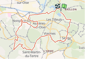
Tocht Stappen van 25 km beschikbaar op Île-de-France, Val-d'Oise, Asnières-sur-Oise. Deze tocht wordt voorgesteld door tracegps.
Beschrijving
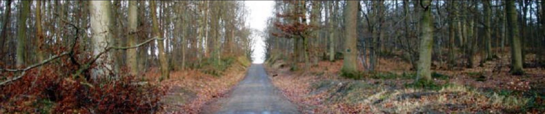
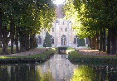
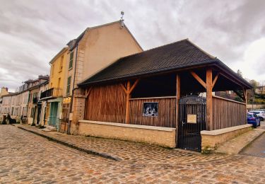
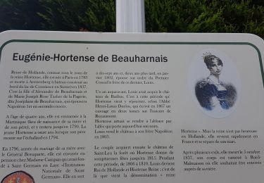
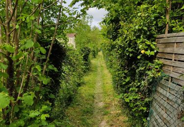
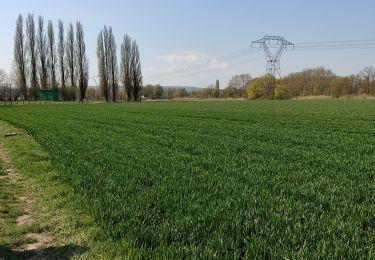
Circuit proposé par le Comité Départemental de Randonnée des Hauts de Seine. Curiosités : Abbaye de Royaumont, Tour télégraphe de Saint-Martin-du-Tertre, Eglise de Noisy-sur-Oise. Attention, GR1A très boueux, à éviter par temps de pluie. Parking départ : Abbaye de Royaumont ou gare de Viarmes. Descriptif : PR17, Royaumont, le Moulin Giez, Seugy ... GR1, le Trou à Loup, Viarmes ... nb puis PR16, Saint Martin-du-Tertre, parcelle 53 ... GR1, (option AR la Pierre Turquaise (1500m), le Lac Bleu (13 km), Noisy-sur-Oise (variante 22 km, nb, D 922, la Gueule-à-Vache), Asnières sur Oise ... GR1A, la Gueule-à-Vache, le Poirier-Gris .... PR17, Royaumont. Des sentiers ont pu être modifiés depuis la dernière validation et les itinéraires proposés n’engagent pas la responsabilité du Comité. Signalez-nous les modifications rencontrées pour mise à jour de la randothèque.
Plaatsbepaling
Opmerkingen
Wandeltochten in de omgeving
![Tocht Stappen Boran-sur-Oise - randonnée abbaye de Royaumont - Photo](https://media.geolcdn.com/t/375/260/9e39e4a0-eda1-4b72-bd45-4ab1609b4c88.jpg&format=jpg&maxdim=2)
![Stappen Stappen](https://static1.geolcdn.com/sitytour/trail-icons/101.png)
Stappen
![](/images/other/stat-length.png)
![](https://static1.geolcdn.com/siteimages/upload/files/16400158638029165_repeat_loop_refresh_sync_direction_icon.png)
![Tocht Stappen Luzarches - Autour d'Orry la Ville - Photo](https://media.geolcdn.com/t/375/260/ext.jpg?maxdim=2&url=https%3A%2F%2Fservices.sitytrail.com%2FGeolivesWS%2FDownloadMedia.ashx%3FTrailID%3D110190%26Media%3D5411_1.jpg)
![Stappen Stappen](https://static1.geolcdn.com/sitytour/trail-icons/101.png)
Stappen
![](/images/other/stat-length.png)
![](https://static1.geolcdn.com/siteimages/upload/files/16400158638029165_repeat_loop_refresh_sync_direction_icon.png)
![Tocht Stappen Viarmes - Autour de l'Abbaye de Royaumont en bord de l'Oise - Photo](https://media.geolcdn.com/t/375/260/ext.jpg?maxdim=2&url=https%3A%2F%2Fservices.sitytrail.com%2FGeolivesWS%2FDownloadMedia.ashx%3FTrailID%3D102743%26Media%3D3879_1.jpg)
![Stappen Stappen](https://static1.geolcdn.com/sitytour/trail-icons/101.png)
Stappen
![](/images/other/stat-length.png)
![](https://static1.geolcdn.com/siteimages/upload/files/16400158638029165_repeat_loop_refresh_sync_direction_icon.png)
![Tocht Stappen Luzarches - Boucle 30 km le trèfle de Luzarches - Photo](https://media.geolcdn.com/t/375/260/a3bd6216-c6bc-4af1-9eae-87e3706e4d02.jpg&format=jpg&maxdim=2)
![Stappen Stappen](https://static1.geolcdn.com/sitytour/trail-icons/101.png)
Stappen
![](/images/other/stat-length.png)
![](https://static1.geolcdn.com/siteimages/upload/files/16400158638029165_repeat_loop_refresh_sync_direction_icon.png)
![Tocht Stappen Boran-sur-Oise - boran Le Lys - Photo](https://media.geolcdn.com/t/375/260/4819a07e-0b5c-4197-bc24-63181ff51320.jpg&format=jpg&maxdim=2)
![Stappen Stappen](https://static1.geolcdn.com/sitytour/trail-icons/101.png)
Stappen
![](/images/other/stat-length.png)
![](https://static1.geolcdn.com/siteimages/upload/files/16400158638029165_repeat_loop_refresh_sync_direction_icon.png)
![Tocht Stappen Viarmes - VIARMES BOUCLE 16 KM - Photo](https://media.geolcdn.com/t/375/260/ext.jpg?maxdim=2&url=https%3A%2F%2Fstatic1.geolcdn.com%2Fsiteimages%2Fupload%2Ffiles%2F1553511878bg_sport_marche.png)
![Stappen Stappen](https://static1.geolcdn.com/sitytour/trail-icons/101.png)
Stappen
![](/images/other/stat-length.png)
![](https://static1.geolcdn.com/siteimages/upload/files/16400158638029165_repeat_loop_refresh_sync_direction_icon.png)
![Tocht Stappen Asnières-sur-Oise - Grand tour de L'Abaye de Royaumont - Photo](https://media.geolcdn.com/t/375/260/748ebf9a-fe1f-4910-8542-5c05e8fce163.jpg&format=jpg&maxdim=2)
![Stappen Stappen](https://static1.geolcdn.com/sitytour/trail-icons/101.png)
Stappen
![](/images/other/stat-length.png)
![](https://static1.geolcdn.com/siteimages/upload/files/16400158638029165_repeat_loop_refresh_sync_direction_icon.png)
![Tocht Stappen Noisy-sur-Oise - forêt de carnelle - Photo](https://media.geolcdn.com/t/375/260/1d38ae56-1525-4792-8527-98abbf8f2f7b.jpg&format=jpg&maxdim=2)
![Stappen Stappen](https://static1.geolcdn.com/sitytour/trail-icons/101.png)
Stappen
![](/images/other/stat-length.png)
![](https://static1.geolcdn.com/siteimages/upload/files/16400158638029165_repeat_loop_refresh_sync_direction_icon.png)
![Tocht Stappen Boran-sur-Oise - randonnée de precy entre campagne et le long de l oise - Photo](https://media.geolcdn.com/t/375/260/6b4b8490-f027-4df3-8fd9-e515b13b2b69.jpg&format=jpg&maxdim=2)
![Stappen Stappen](https://static1.geolcdn.com/sitytour/trail-icons/101.png)
Stappen
![](/images/other/stat-length.png)
![](https://static1.geolcdn.com/siteimages/upload/files/16400158638029165_repeat_loop_refresh_sync_direction_icon.png)