![](/images/other/stat-length.png)
![Tocht Stappen Norroy-le-Veneur - Randonnée au Pays de la Noix - Norroy le Veneur - Photo](https://media.geolcdn.com/t/1900/400/ext.pjpeg?maxdim=2&url=https%3A%2F%2Fservices.sitytrail.com%2FGeolivesWS%2FDownloadMedia.ashx%3FTrailID%3D110119%26Media%3D5299_1.jpg)
Randonnée au Pays de la Noix - Norroy le Veneur
tracegps
Gebruiker
![Lengte](/images/other/stat-length.png)
![Max. hoogte](https://static1.geolcdn.com/siteimages/upload/files/1508320355ic_sort_altitude_max_24dp.png)
![Positief hoogteverschil](https://static1.geolcdn.com/siteimages/upload/files/1508320355ic_sort_den_pos_24dp.png)
![Km-Effort](/images/other/stat-length.png)
![Min. hoogte](https://static1.geolcdn.com/siteimages/upload/files/1508320355ic_sort_altitude_min_24dp.png)
![Negatief hoogteverschil](https://static1.geolcdn.com/siteimages/upload/files/1508320355ic_sort_den_neg_24dp.png)
![Boucle](https://static1.geolcdn.com/siteimages/upload/files/16400158638029165_repeat_loop_refresh_sync_direction_icon.png)
![Stappen](https://static1.geolcdn.com/sitytour/trail-icons/101.png)
2h00
Moeilijkheid : Medium
![Scan deze QR-code om de tocht te openen in de SityTrail-applicatie](https://capi.geolives.com/qq0zvz2zws4bq2lad0pu/sitytour/trails/110119/qr.png?size=200)
Gratisgps-wandelapplicatie
Over ons
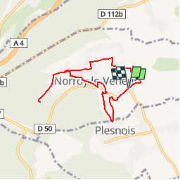
Tocht Stappen van 6,4 km beschikbaar op Grand Est, Moselle, Norroy-le-Veneur. Deze tocht wordt voorgesteld door tracegps.
Beschrijving
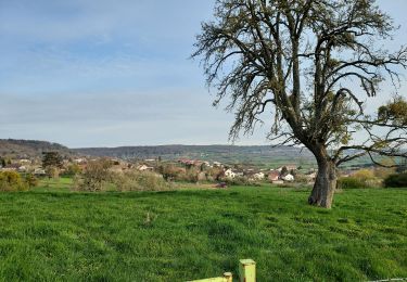
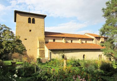
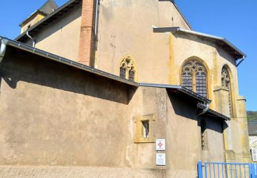
Si le village de Norroy doit son nom aux noix (de « Nogaredum » : le Pays de la Noix), il est aussi connu pour ses vignes jusqu’au XIXe siècle. Pour contrer les ravages du Phylloxéra, il développera la culture fruitière, fraises et fruitiers dont témoignent les vergers qui occupent encore les versants. Occupé avec certitude depuis l’époque Mérovingienne, le village s’enorgueillit aussi d’un patrimoine bâti exceptionnel : de nombreuses fontaines, son église fortifiée et l’ancien moulin dont la dernière extension et la roue à godets datent de 1845. Retrouvez la fiche de cette randonnée sur le site du Tourisme en Moselle.
Plaatsbepaling
Opmerkingen
Wandeltochten in de omgeving
![Tocht Te voet Lessy - Circuit de Plappeville - Photo](https://media.geolcdn.com/t/375/260/7273a269-0c57-4318-8c49-dbed329cb79a.jpeg&format=jpg&maxdim=2)
![Te voet Te voet](https://static1.geolcdn.com/sitytour/trail-icons/100.png)
Te voet
![](/images/other/stat-length.png)
![](https://static1.geolcdn.com/siteimages/upload/files/16400158638029165_repeat_loop_refresh_sync_direction_icon.png)
![Tocht Stappen Saulny - plesnois - Photo](https://media.geolcdn.com/t/375/260/30dd64af-04ad-4ba2-adb2-9542b50b478b.jpg&format=jpg&maxdim=2)
![Stappen Stappen](https://static1.geolcdn.com/sitytour/trail-icons/101.png)
![Tocht Stappen Saulny - Saulny 8 mai 2013 14 km - Photo](https://media.geolcdn.com/t/375/260/ext.jpg?maxdim=2&url=https%3A%2F%2Fstatic1.geolcdn.com%2Fsiteimages%2Fupload%2Ffiles%2F1553511878bg_sport_marche.png)
![Stappen Stappen](https://static1.geolcdn.com/sitytour/trail-icons/101.png)
Stappen
![](/images/other/stat-length.png)
![](https://static1.geolcdn.com/siteimages/upload/files/16400158638029165_repeat_loop_refresh_sync_direction_icon.png)
![Tocht Paard Woippy - Vers chez Sam - Photo](https://media.geolcdn.com/t/375/260/ext.jpg?maxdim=2&url=https%3A%2F%2Fstatic1.geolcdn.com%2Fsiteimages%2Fupload%2Ffiles%2F1524743154cheval.jpg)
![Paard Paard](https://static1.geolcdn.com/sitytour/trail-icons/300.png)
Paard
![](/images/other/stat-length.png)
![](https://static1.geolcdn.com/siteimages/upload/files/16400158638029165_repeat_loop_refresh_sync_direction_icon.png)
![Tocht Stappen Norroy-le-Veneur - pic agnel - Photo](https://media.geolcdn.com/t/375/260/8dc837e7-6d82-4101-8d09-3c51748fc432.jpg&format=jpg&maxdim=2)
![Stappen Stappen](https://static1.geolcdn.com/sitytour/trail-icons/101.png)
Stappen
![](/images/other/stat-length.png)
![](https://static1.geolcdn.com/siteimages/upload/files/16400158638029165_repeat_loop_refresh_sync_direction_icon.png)
![Tocht Te voet Saulny - Circuit du Parc de la Gentière - Photo](https://media.geolcdn.com/t/375/260/92b2f754-c0d5-4dd8-88ba-a3d3a7f7725d.jpeg&format=jpg&maxdim=2)
![Te voet Te voet](https://static1.geolcdn.com/sitytour/trail-icons/100.png)
Te voet
![](/images/other/stat-length.png)
![](https://static1.geolcdn.com/siteimages/upload/files/16400158638029165_repeat_loop_refresh_sync_direction_icon.png)
![Tocht Te voet Saulny - Circuit du Fort de Lorraine - Photo](https://media.geolcdn.com/t/375/260/20aefaf0-d1d3-4f09-9c17-e80cbcd18eff.jpeg&format=jpg&maxdim=2)
![Te voet Te voet](https://static1.geolcdn.com/sitytour/trail-icons/100.png)
Te voet
![](/images/other/stat-length.png)
![](https://static1.geolcdn.com/siteimages/upload/files/16400158638029165_repeat_loop_refresh_sync_direction_icon.png)
![Tocht Te voet Marange-Silvange - Circuit de la Croix David - Photo](https://media.geolcdn.com/t/375/260/17e0c214-c60d-41b0-ab2a-4291b557f474.jpeg&format=jpg&maxdim=2)
![Te voet Te voet](https://static1.geolcdn.com/sitytour/trail-icons/100.png)
Te voet
![](/images/other/stat-length.png)
![](https://static1.geolcdn.com/siteimages/upload/files/16400158638029165_repeat_loop_refresh_sync_direction_icon.png)
![Tocht Te voet Saulny - Saulny Circuit Saint-Maurice - Photo](https://media.geolcdn.com/t/375/260/92b2f754-c0d5-4dd8-88ba-a3d3a7f7725d.jpeg&format=jpg&maxdim=2)
![Te voet Te voet](https://static1.geolcdn.com/sitytour/trail-icons/100.png)
Te voet
![](/images/other/stat-length.png)
![](https://static1.geolcdn.com/siteimages/upload/files/16400158638029165_repeat_loop_refresh_sync_direction_icon.png)