![](/images/other/stat-length.png)
![Tocht Stappen Escot - Pic Roumendarès 1646m - Photo](https://media.geolcdn.com/t/1900/400/ext.pjpeg?maxdim=2&url=https%3A%2F%2Fservices.sitytrail.com%2FGeolivesWS%2FDownloadMedia.ashx%3FTrailID%3D110006%26Media%3D5094_1.jpg)
Pic Roumendarès 1646m
tracegps
Gebruiker
![Lengte](/images/other/stat-length.png)
![Max. hoogte](https://static1.geolcdn.com/siteimages/upload/files/1508320355ic_sort_altitude_max_24dp.png)
![Positief hoogteverschil](https://static1.geolcdn.com/siteimages/upload/files/1508320355ic_sort_den_pos_24dp.png)
![Km-Effort](/images/other/stat-length.png)
![Min. hoogte](https://static1.geolcdn.com/siteimages/upload/files/1508320355ic_sort_altitude_min_24dp.png)
![Negatief hoogteverschil](https://static1.geolcdn.com/siteimages/upload/files/1508320355ic_sort_den_neg_24dp.png)
![Boucle](https://static1.geolcdn.com/siteimages/upload/files/16400158638029165_repeat_loop_refresh_sync_direction_icon.png)
![Stappen](https://static1.geolcdn.com/sitytour/trail-icons/101.png)
4h15
Moeilijkheid : Moeilijk
![Scan deze QR-code om de tocht te openen in de SityTrail-applicatie](https://capi.geolives.com/qq0zvz2zws4bq2lad0pu/sitytour/trails/110006/qr.png?size=200)
Gratisgps-wandelapplicatie
Over ons
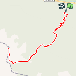
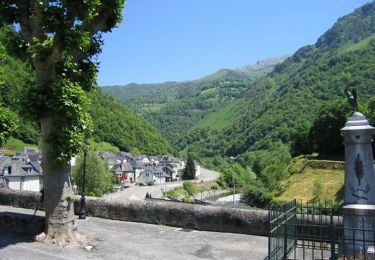
Tocht Stappen van 6,2 km beschikbaar op Nieuw-Aquitanië, Pyrénées-Atlantiques, Escot. Deze tocht wordt voorgesteld door tracegps.
Beschrijving
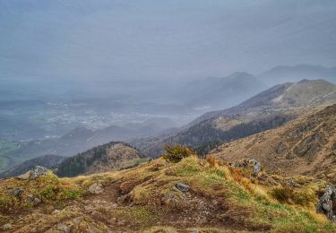
Le Pic Roumendarès 1646m depuis la route du col de Marie-blanque (770m) Redouté des cyclistes, la D924 reliant Escot au col de Marie-Blanque est bordée au Sud par une élégante crête calcaire dont les sommets Est (Rocher d'Aran, Ourlenotte, Ourlène) sont assez bien connus et fréquentés par les Palois. Les pics situés plus à l'Ouest, intéressants belvédères sur le massif de l'Anie et sur la chaîne frontière, sont peu aisés à atteindre en partant de la vallée d'Aspe ? L’astuce, consiste à les "attaquer par le Nord". Difficulté: Sentier raide, parfois peu marqué. D’autres indications, photos et panoramiques sur le site « Les Pyrénées vues par Mariano ».
Plaatsbepaling
Opmerkingen
Wandeltochten in de omgeving
![Tocht Te voet Sarrance - SARRANCE / ACCOUS collecte numerique GR 653 10 - Photo](https://media.geolcdn.com/t/375/260/6af0ffae-8b6f-4ace-a0bc-1da8fe58ba0f.jpg&format=jpg&maxdim=2)
![Te voet Te voet](https://static1.geolcdn.com/sitytour/trail-icons/100.png)
Te voet
![](/images/other/stat-length.png)
![](https://static1.geolcdn.com/siteimages/upload/files/16400158638029165_repeat_loop_refresh_sync_direction_icon.png)
![Tocht Stappen Bilhères - Pic des escurets 1440m en Aller-Retour - Photo](https://media.geolcdn.com/t/375/260/04e8397a-3e96-40a9-9dfb-62d886cbf2e5.jpg&format=jpg&maxdim=2)
![Stappen Stappen](https://static1.geolcdn.com/sitytour/trail-icons/101.png)
Stappen
![](/images/other/stat-length.png)
![](https://static1.geolcdn.com/siteimages/upload/files/16400158638029165_repeat_loop_refresh_sync_direction_icon.png)
![Tocht Te voet Escot - Tour Bilboquet-Barescou asp01 - Photo](https://media.geolcdn.com/t/375/260/55ff453c-cab8-4ca7-b81d-a7758b36c1ff.jpeg&format=jpg&maxdim=2)
![Te voet Te voet](https://static1.geolcdn.com/sitytour/trail-icons/100.png)
Te voet
![](/images/other/stat-length.png)
![](https://static1.geolcdn.com/siteimages/upload/files/16400158638029165_repeat_loop_refresh_sync_direction_icon.png)
![Tocht Stappen Bilhères - BILHERES en OSSAU pic des escurets G3 - Photo](https://media.geolcdn.com/t/375/260/ad43eef3-8624-4c4f-b44c-44af792335b0.jpg&format=jpg&maxdim=2)
![Stappen Stappen](https://static1.geolcdn.com/sitytour/trail-icons/101.png)
Stappen
![](/images/other/stat-length.png)
![](https://static1.geolcdn.com/siteimages/upload/files/16400158638029165_repeat_loop_refresh_sync_direction_icon.png)
![Tocht Stappen Escot - escot le bilboquet G3 fait - Photo](https://media.geolcdn.com/t/375/260/070b4e50-20d7-44d9-8406-b0b9c0063d99.jpg&format=jpg&maxdim=2)
![Stappen Stappen](https://static1.geolcdn.com/sitytour/trail-icons/101.png)
Stappen
![](/images/other/stat-length.png)
![](https://static1.geolcdn.com/siteimages/upload/files/16400158638029165_repeat_loop_refresh_sync_direction_icon.png)
![Tocht Trail Sarrance - Col Laundé - Photo](https://media.geolcdn.com/t/375/260/2ca6411c-420c-4c54-997a-50e1e4cfec54.jpg&format=jpg&maxdim=2)
![Trail Trail](https://static1.geolcdn.com/sitytour/trail-icons/104.png)
Trail
![](/images/other/stat-length.png)
![](https://static1.geolcdn.com/siteimages/upload/files/16400158638029165_repeat_loop_refresh_sync_direction_icon.png)
![Tocht Fiets Escot - Transpyrénéenne en cyclo - étape 3 - Escot à Luz Saint Sauveur - Photo](https://media.geolcdn.com/t/375/260/ext.jpg?maxdim=2&url=https%3A%2F%2Fservices.sitytrail.com%2FGeolivesWS%2FDownloadMedia.ashx%3FTrailID%3D105671%26Media%3D9492_1.jpg)
![Fiets Fiets](https://static1.geolcdn.com/sitytour/trail-icons/200.png)
Fiets
![](/images/other/stat-length.png)
![](https://static1.geolcdn.com/siteimages/upload/files/16400158638029165_repeat_loop_refresh_sync_direction_icon.png)
![Tocht Stappen Sarrance - Chemin d'Arles à Compostelle - Sarrance - Urdos - Photo](https://media.geolcdn.com/t/375/260/ext.jpg?maxdim=2&url=https%3A%2F%2Fservices.sitytrail.com%2FGeolivesWS%2FDownloadMedia.ashx%3FTrailID%3D105161%26Media%3D8788_1.jpg)
![Stappen Stappen](https://static1.geolcdn.com/sitytour/trail-icons/101.png)
Stappen
![](/images/other/stat-length.png)
![](https://static1.geolcdn.com/siteimages/upload/files/16400158638029165_repeat_loop_refresh_sync_direction_icon.png)
![Tocht Te voet Sarrance - LOURDIOS / ACCOUS G4 GR653](https://media.geolcdn.com/t/375/260/ext.jpg?maxdim=2&url=https%3A%2F%2Fstatic1.geolcdn.com%2Fsiteimages%2Fupload%2Ffiles%2F1545311037marcheuse_200dpi.jpg)
![Te voet Te voet](https://static1.geolcdn.com/sitytour/trail-icons/100.png)
Te voet
![](/images/other/stat-length.png)
![](https://static1.geolcdn.com/siteimages/upload/files/16400158638029165_repeat_loop_refresh_sync_direction_icon.png)