![](/images/other/stat-length.png)
![Tocht Stappen Estaing - Le Grand Barbat 2813m depuis le lac d'Estaing - Photo](https://media.geolcdn.com/t/1900/400/ext.pjpeg?maxdim=2&url=https%3A%2F%2Fservices.sitytrail.com%2FGeolivesWS%2FDownloadMedia.ashx%3FTrailID%3D109862%26Media%3D4849_1.jpg)
Le Grand Barbat 2813m depuis le lac d'Estaing
tracegps
Gebruiker
![Lengte](/images/other/stat-length.png)
![Max. hoogte](https://static1.geolcdn.com/siteimages/upload/files/1508320355ic_sort_altitude_max_24dp.png)
![Positief hoogteverschil](https://static1.geolcdn.com/siteimages/upload/files/1508320355ic_sort_den_pos_24dp.png)
![Km-Effort](/images/other/stat-length.png)
![Min. hoogte](https://static1.geolcdn.com/siteimages/upload/files/1508320355ic_sort_altitude_min_24dp.png)
![Negatief hoogteverschil](https://static1.geolcdn.com/siteimages/upload/files/1508320355ic_sort_den_neg_24dp.png)
![Boucle](https://static1.geolcdn.com/siteimages/upload/files/16400158638029165_repeat_loop_refresh_sync_direction_icon.png)
![Stappen](https://static1.geolcdn.com/sitytour/trail-icons/101.png)
9h00
Moeilijkheid : Zeer moeilijk
![Scan deze QR-code om de tocht te openen in de SityTrail-applicatie](https://capi.geolives.com/qq0zvz2zws4bq2lad0pu/sitytour/trails/109862/qr.png?size=200)
Gratisgps-wandelapplicatie
Over ons
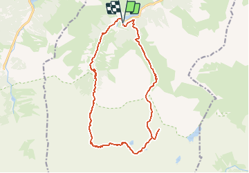
Tocht Stappen van 17,9 km beschikbaar op Occitanië, Hautes-Pyrénées, Estaing. Deze tocht wordt voorgesteld door tracegps.
Beschrijving
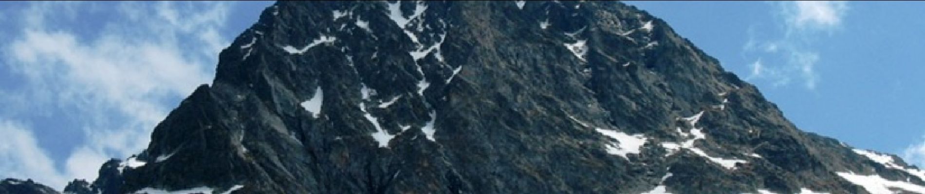
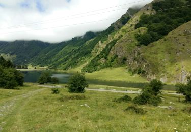
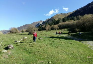
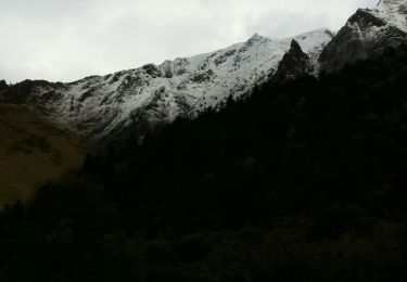
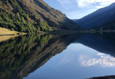
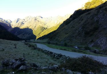
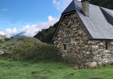
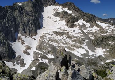
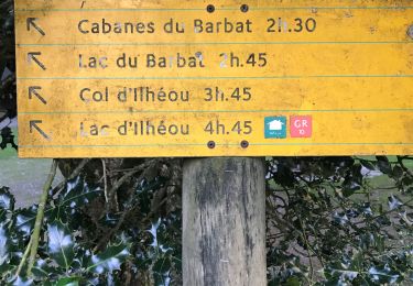
Le Grand Barbat 2813m depuis le lac d'Estaing (1162m) L'impressionnante dénivellation ne doit pas vous dissuader d'entreprendre cette ascension à la portée de tous randonneurs en bonne condition physique: la récompense est au sommet, avec un immense et splendide panorama. Le retour par les lacs situés au Nord du pic Arrouy permet un circuit très varié à travers des paysages typiquement pyrénéens. Difficulté: Dénivelée considérable. (Pour randonneurs en très bonne condition physique) D’autres indications, photos et panoramiques sur le site « Les Pyrénées vues par Mariano ». Crédit photos François Bres
Plaatsbepaling
Opmerkingen
Wandeltochten in de omgeving
![Tocht Stappen Estaing - Les Viellettes - Estaing - Photo](https://media.geolcdn.com/t/375/260/ext.jpg?maxdim=2&url=https%3A%2F%2Fservices.sitytrail.com%2FGeolivesWS%2FDownloadMedia.ashx%3FTrailID%3D101311%26Media%3D806_1.jpg)
![Stappen Stappen](https://static1.geolcdn.com/sitytour/trail-icons/101.png)
Stappen
![](/images/other/stat-length.png)
![](https://static1.geolcdn.com/siteimages/upload/files/16400158638029165_repeat_loop_refresh_sync_direction_icon.png)
![Tocht Stappen Estaing - ESTAING RS le der de 2022 - Photo](https://media.geolcdn.com/t/375/260/0404f897-2945-4225-b4b6-dbaf65ce5d84.jpg&format=jpg&maxdim=2)
![Stappen Stappen](https://static1.geolcdn.com/sitytour/trail-icons/101.png)
Stappen
![](/images/other/stat-length.png)
![](https://static1.geolcdn.com/siteimages/upload/files/16400158638029165_repeat_loop_refresh_sync_direction_icon.png)
![Tocht Stappen Estaing - ESTAING autour du lac - Photo](https://media.geolcdn.com/t/375/260/85a18d35-dba9-4c5a-81ce-af3373d459ba.jpg&format=jpg&maxdim=2)
![Stappen Stappen](https://static1.geolcdn.com/sitytour/trail-icons/101.png)
Stappen
![](/images/other/stat-length.png)
![](https://static1.geolcdn.com/siteimages/upload/files/16400158638029165_repeat_loop_refresh_sync_direction_icon.png)
![Tocht Stappen Estaing - ESTAING et la cabane d'Ariousse](https://media.geolcdn.com/t/375/260/971dcf36-56bc-4869-8714-f69942a6f793.jpg&format=jpg&maxdim=2)
![Stappen Stappen](https://static1.geolcdn.com/sitytour/trail-icons/101.png)
Stappen
![](/images/other/stat-length.png)
![](https://static1.geolcdn.com/siteimages/upload/files/16400158638029165_repeat_loop_refresh_sync_direction_icon.png)
![Tocht Stappen Estaing - Ruines et lac de Liantran - Photo](https://media.geolcdn.com/t/375/260/1b91bce4-1111-454c-9093-1e2ab24d6024.jpg&format=jpg&maxdim=2)
![Stappen Stappen](https://static1.geolcdn.com/sitytour/trail-icons/101.png)
Stappen
![](/images/other/stat-length.png)
![](https://static1.geolcdn.com/siteimages/upload/files/16400158638029165_repeat_loop_refresh_sync_direction_icon.png)
![Tocht Stappen Estaing - ESTAING Cabane d'Ariousec en boucle G3 - Photo](https://media.geolcdn.com/t/375/260/dc2e5807-7e79-4cc0-b670-bf7996730f23.jpg&format=jpg&maxdim=2)
![Stappen Stappen](https://static1.geolcdn.com/sitytour/trail-icons/101.png)
Stappen
![](/images/other/stat-length.png)
![](https://static1.geolcdn.com/siteimages/upload/files/16400158638029165_repeat_loop_refresh_sync_direction_icon.png)
![Tocht Stappen Estaing - Le lac d'Estaing - Photo](https://media.geolcdn.com/t/375/260/99541acc-32e8-489c-8cb9-fb928bd0dc43.jpg&format=jpg&maxdim=2)
![Stappen Stappen](https://static1.geolcdn.com/sitytour/trail-icons/101.png)
Stappen
![](/images/other/stat-length.png)
![](https://static1.geolcdn.com/siteimages/upload/files/16400158638029165_repeat_loop_refresh_sync_direction_icon.png)
![Tocht Stappen Arrens-Marsous - pic de cristayet - Photo](https://media.geolcdn.com/t/375/260/4c1e26d5-197f-441e-9709-6adb4628c945.jpg&format=jpg&maxdim=2)
![Stappen Stappen](https://static1.geolcdn.com/sitytour/trail-icons/101.png)
Stappen
![](/images/other/stat-length.png)
![](https://static1.geolcdn.com/siteimages/upload/files/16400158638029165_repeat_loop_refresh_sync_direction_icon.png)
![Tocht Stappen Estaing - Pyrénées jour 4 - Photo](https://media.geolcdn.com/t/375/260/5c6b756a-151d-456f-a813-d2eed350fb7d.jpg&format=jpg&maxdim=2)
![Stappen Stappen](https://static1.geolcdn.com/sitytour/trail-icons/101.png)
Stappen
![](/images/other/stat-length.png)
![](https://static1.geolcdn.com/siteimages/upload/files/16400158638029165_repeat_loop_refresh_sync_direction_icon.png)