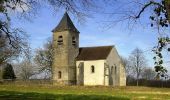

Chapelles autour de Brinon

tracegps
Gebruiker

Lengte
19 km

Max. hoogte
393 m

Positief hoogteverschil
445 m

Km-Effort
25 km

Min. hoogte
192 m

Negatief hoogteverschil
445 m
Boucle
Ja
Datum van aanmaak :
2014-12-10 00:00:00.0
Laatste wijziging :
2014-12-10 00:00:00.0
4h30
Moeilijkheid : Zeer moeilijk

Gratisgps-wandelapplicatie
Over ons
Tocht Stappen van 19 km beschikbaar op Bourgondië-Franche-Comté, Nièvre, Brinon-sur-Beuvron. Deze tocht wordt voorgesteld door tracegps.
Beschrijving
Un circuit proposé par le Syndicat d'Initiative de Brinon-sur-Beuvron. Départ de Brinon-sur-Beuvron. C'est une balade sportive sur les chemins de crête de la vallée du Beuvron, à la découverte d'un riche patrimoine de chapelles datant du 12eme siècle.
Plaatsbepaling
Land:
France
Regio :
Bourgondië-Franche-Comté
Departement/Provincie :
Nièvre
Gemeente :
Brinon-sur-Beuvron
Locatie:
Unknown
Vertrek:(Dec)
Vertrek:(UTM)
537138 ; 5236390 (31T) N.
Opmerkingen
Wandeltochten in de omgeving

ASNAN1


Stappen
Gemakkelijk
Asnan,
Bourgondië-Franche-Comté,
Nièvre,
France

23 km | 29 km-effort
6h 9min
Ja

olcy a michaugue


Stappen
Heel gemakkelijk
Neuilly,
Bourgondië-Franche-Comté,
Nièvre,
France

5,5 km | 6,6 km-effort
1h 39min
Ja

chapelles autour de brinon


Stappen
Medium
Brinon-sur-Beuvron,
Bourgondië-Franche-Comté,
Nièvre,
France

19 km | 25 km-effort
Onbekend
Ja


 SityTrail


