![](/images/other/stat-length.png)
![Tocht Stappen Lectoure - Lectoure - La Romieu - Chemin de Compostelle - Photo](https://media.geolcdn.com/t/1900/400/ext.pjpeg?maxdim=2&url=https%3A%2F%2Fservices.sitytrail.com%2FGeolivesWS%2FDownloadMedia.ashx%3FTrailID%3D109610%26Media%3D4220_4.jpg)
Lectoure - La Romieu - Chemin de Compostelle
tracegps
Gebruiker
![Lengte](/images/other/stat-length.png)
![Max. hoogte](https://static1.geolcdn.com/siteimages/upload/files/1508320355ic_sort_altitude_max_24dp.png)
![Positief hoogteverschil](https://static1.geolcdn.com/siteimages/upload/files/1508320355ic_sort_den_pos_24dp.png)
![Km-Effort](/images/other/stat-length.png)
![Min. hoogte](https://static1.geolcdn.com/siteimages/upload/files/1508320355ic_sort_altitude_min_24dp.png)
![Negatief hoogteverschil](https://static1.geolcdn.com/siteimages/upload/files/1508320355ic_sort_den_neg_24dp.png)
![Boucle](https://static1.geolcdn.com/siteimages/upload/files/16400158638029165_repeat_loop_refresh_sync_direction_icon.png)
![Stappen](https://static1.geolcdn.com/sitytour/trail-icons/101.png)
7h10
Moeilijkheid : Zeer moeilijk
![Scan deze QR-code om de tocht te openen in de SityTrail-applicatie](https://capi.geolives.com/qq0zvz2zws4bq2lad0pu/sitytour/trails/109610/qr.png?size=200)
Gratisgps-wandelapplicatie
Over ons
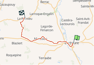
Tocht Stappen van 19,6 km beschikbaar op Occitanië, Gers, Lectoure. Deze tocht wordt voorgesteld door tracegps.
Beschrijving
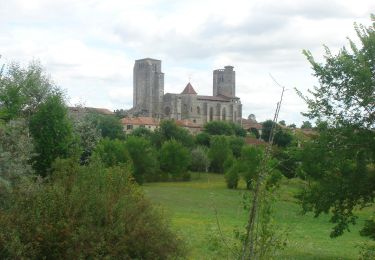
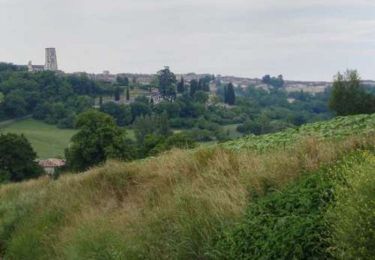
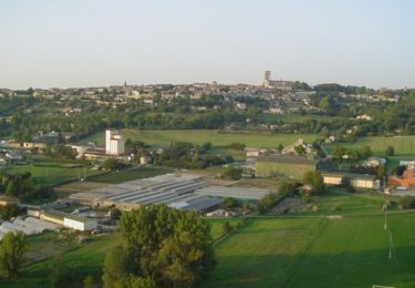
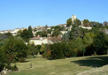
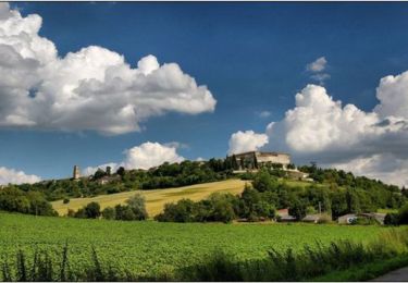
Nous avons pris untrès bon petit déjeuner au gîte Le Pèlerin d'Occident (Véronique Pautrel et Patrick Davet, 28 rue Sainte Claire, 32700 Lectoure, 05 62 28 50 35 & 06 25 79 40 61). Départ 7H50 Depuis la Cathédrale, descendre vers la Fontaine de Diane (0:20) et prendre une rue qui descend à droite pour revenir sur la N21. Tourner à gauche puis immédiatement à droite pour redescendre une route menant à la coopérative. Prendre à droite sur la grande rue puis à gauche pour rallier Pradoulin (0:40). Prendre à droite pour longer la vie ferrée et rejoindre la D7. Passer le Pont de Pile sur le Gers à gauche puis un chemin de terre à droite. Couper la D36 et passer Grabiou (1:10), Hausset (1:25) et Espasot (1:40). Aller à droite vers Marides (1:55) jusqu'à la Croix de la Justice (2:20). Une petite pose est la bienvenue (0:20). Quitter la route pour prendre un chemin de terre à droite, passer Jouet puis, 300m après, revenir à gauche sur Marsolan (3:10). Descendre la rue principale, croiser la D166, passer l'Auchie et remonter en face. Longue remontée sur le plateau jusqu'à un moulin restauré (4:10). Passer à gauche et passer au dessus de La Tuilerie. On trouve des endroit arborés propices aux casse croute! (4:25). (5:15) Passer Montravail et Batsurguère puis prendre un chemin qui descend vers le Lion d'Or et remonte au Bois de la Ville (6:10). Au sortir du bois, prendre à droite sur quelques mètres puis à gauche pour longer une forêt et des fruitiers. Prendre un chemin à droite vers La Bourdette (6:50). La Cathédrale de La Romieu se dévoile, magnifique! Rejoindre la D41 qui contourne le centre historique du village (7:10).
Plaatsbepaling
Opmerkingen
Wandeltochten in de omgeving
![Tocht Stappen Lectoure - GR65 Lectoure > La Romieu - Photo](https://media.geolcdn.com/t/375/260/f56c4977-4bb0-4636-b10f-0a2a2329de52.jpg&format=jpg&maxdim=2)
![Stappen Stappen](https://static1.geolcdn.com/sitytour/trail-icons/101.png)
Stappen
![](/images/other/stat-length.png)
![](https://static1.geolcdn.com/siteimages/upload/files/16400158638029165_repeat_loop_refresh_sync_direction_icon.png)
![Stappen Stappen](https://static1.geolcdn.com/sitytour/trail-icons/101.png)
Stappen
![](/images/other/stat-length.png)
![](https://static1.geolcdn.com/siteimages/upload/files/16400158638029165_repeat_loop_refresh_sync_direction_icon.png)
![Tocht Stappen Lectoure - 32-05-Au Cœur de Gascogne Auch-24km-102-5607- - Photo](https://media.geolcdn.com/t/375/260/eedc5c4f-5cf7-4106-9353-e66c52668c78.jpg&format=jpg&maxdim=2)
![Stappen Stappen](https://static1.geolcdn.com/sitytour/trail-icons/101.png)
Stappen
![](/images/other/stat-length.png)
![](https://static1.geolcdn.com/siteimages/upload/files/16400158638029165_repeat_loop_refresh_sync_direction_icon.png)
![Tocht Stappen Lectoure - espazot condom 13.7.2017 - Photo](https://media.geolcdn.com/t/375/260/ext.jpg?maxdim=2&url=https%3A%2F%2Fservices.sitytrail.com%2FGeolivesWS%2FDownloadMedia.ashx%3FTrailID%3D788942%26Media%3D20170713141850.jpg)
![Stappen Stappen](https://static1.geolcdn.com/sitytour/trail-icons/101.png)
Stappen
![](/images/other/stat-length.png)
![](https://static1.geolcdn.com/siteimages/upload/files/16400158638029165_repeat_loop_refresh_sync_direction_icon.png)
![Tocht Stappen Lectoure - Lac des trois vallées - Lectoure - Photo](https://media.geolcdn.com/t/375/260/ext.jpg?maxdim=2&url=https%3A%2F%2Fservices.sitytrail.com%2FGeolivesWS%2FDownloadMedia.ashx%3FTrailID%3D111907%26Media%3D8912_2.jpg)
![Stappen Stappen](https://static1.geolcdn.com/sitytour/trail-icons/101.png)
Stappen
![](/images/other/stat-length.png)
![](https://static1.geolcdn.com/siteimages/upload/files/16400158638029165_repeat_loop_refresh_sync_direction_icon.png)
![Tocht Stappen Lectoure - Groussan - Lectoure - Photo](https://media.geolcdn.com/t/375/260/ext.jpg?maxdim=2&url=https%3A%2F%2Fservices.sitytrail.com%2FGeolivesWS%2FDownloadMedia.ashx%3FTrailID%3D111906%26Media%3D8911_2.jpg)
![Stappen Stappen](https://static1.geolcdn.com/sitytour/trail-icons/101.png)
Stappen
![](/images/other/stat-length.png)
![](https://static1.geolcdn.com/siteimages/upload/files/16400158638029165_repeat_loop_refresh_sync_direction_icon.png)
![Tocht Stappen Lectoure - Arton - Lectoure - Photo](https://media.geolcdn.com/t/375/260/ext.jpg?maxdim=2&url=https%3A%2F%2Fservices.sitytrail.com%2FGeolivesWS%2FDownloadMedia.ashx%3FTrailID%3D111785%26Media%3D8301_2.jpg)
![Stappen Stappen](https://static1.geolcdn.com/sitytour/trail-icons/101.png)
![Tocht Stappen Lectoure - Les Galis - Lectoure - Photo](https://media.geolcdn.com/t/375/260/ext.jpg?maxdim=2&url=https%3A%2F%2Fservices.sitytrail.com%2FGeolivesWS%2FDownloadMedia.ashx%3FTrailID%3D111784%26Media%3D8300_2.jpg)
![Stappen Stappen](https://static1.geolcdn.com/sitytour/trail-icons/101.png)
Stappen
![](/images/other/stat-length.png)
![](https://static1.geolcdn.com/siteimages/upload/files/16400158638029165_repeat_loop_refresh_sync_direction_icon.png)
![Tocht Stappen Lectoure - Navère - Lectoure - Photo](https://media.geolcdn.com/t/375/260/ext.jpg?maxdim=2&url=https%3A%2F%2Fservices.sitytrail.com%2FGeolivesWS%2FDownloadMedia.ashx%3FTrailID%3D111783%26Media%3D8299_2.jpg)
![Stappen Stappen](https://static1.geolcdn.com/sitytour/trail-icons/101.png)
Stappen
![](/images/other/stat-length.png)
![](https://static1.geolcdn.com/siteimages/upload/files/16400158638029165_repeat_loop_refresh_sync_direction_icon.png)