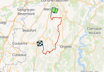
![](/images/other/stat-length.png)
![Tocht Paard Bornay - Geruge - Pimorin - Photo](https://media.geolcdn.com/t/1900/400/ext.pjpeg?maxdim=2&url=https%3A%2F%2Fservices.sitytrail.com%2FGeolivesWS%2FDownloadMedia.ashx%3FTrailID%3D109485%26Media%3D4053_1.jpg)
Geruge - Pimorin
tracegps
Gebruiker
![Lengte](/images/other/stat-length.png)
![Max. hoogte](https://static1.geolcdn.com/siteimages/upload/files/1508320355ic_sort_altitude_max_24dp.png)
![Positief hoogteverschil](https://static1.geolcdn.com/siteimages/upload/files/1508320355ic_sort_den_pos_24dp.png)
![Km-Effort](/images/other/stat-length.png)
![Min. hoogte](https://static1.geolcdn.com/siteimages/upload/files/1508320355ic_sort_altitude_min_24dp.png)
![Negatief hoogteverschil](https://static1.geolcdn.com/siteimages/upload/files/1508320355ic_sort_den_neg_24dp.png)
![Boucle](https://static1.geolcdn.com/siteimages/upload/files/16400158638029165_repeat_loop_refresh_sync_direction_icon.png)
![Paard](https://static1.geolcdn.com/sitytour/trail-icons/300.png)
3h30
Moeilijkheid : Medium
![Scan deze QR-code om de tocht te openen in de SityTrail-applicatie](https://capi.geolives.com/qq0zvz2zws4bq2lad0pu/sitytour/trails/109485/qr.png?size=200)
Gratisgps-wandelapplicatie
Over ons
Tocht Paard van 30 km beschikbaar op Bourgondië-Franche-Comté, Jura, Bornay. Deze tocht wordt voorgesteld door tracegps.
Beschrijving
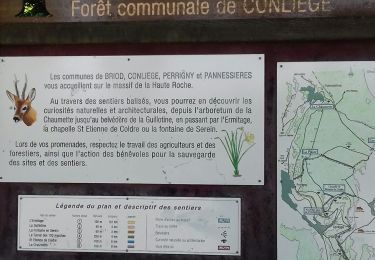
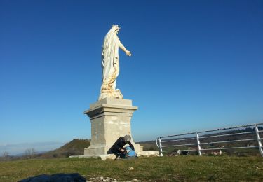
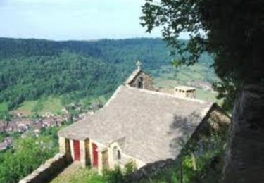
Petite Montagne - Geruge - Pimorin L’association du Jura du Grand huit est née en 1987, elle est spécialisée alors dans la rando à cheval. Elle regroupe des hébergements de randonnée, des professionnels équestres proposant des séjours cheval (rando accompagnées, stages, roulottes…) et des bénévoles baliseurs. Elle entretient, balise et aménage les itinéraires équestres sur le département du Jura. Ses itinéraires sont accessibles aux cavaliers et aux marcheurs, ils permettent de parcourir l’ensemble du département, de la Bresse Jurassienne aux Hautes Combes en passant par le vignoble, les lacs et les plateaux. Le Grand Huit vous propose des idées de séjours en boucle de 2 à plusieurs jours. De multiples possibilités vous sont offertes, vous trouverez sur le site quelques propositions non exhaustives. Attention, les itinéraires peuvent changer d’une année à l’autre et subir des modifications.
Plaatsbepaling
Opmerkingen
Wandeltochten in de omgeving
![Tocht Stappen Montaigu - GR_559_AA_01_Montaigu_Verges_20210912 - Photo](https://media.geolcdn.com/t/375/260/12188aeb-a939-4b90-8b88-de08011287d2.jpg&format=jpg&maxdim=2)
![Stappen Stappen](https://static1.geolcdn.com/sitytour/trail-icons/101.png)
Stappen
![](/images/other/stat-length.png)
![](https://static1.geolcdn.com/siteimages/upload/files/16400158638029165_repeat_loop_refresh_sync_direction_icon.png)
![Stappen Stappen](https://static1.geolcdn.com/sitytour/trail-icons/101.png)
Stappen
![](/images/other/stat-length.png)
![](https://static1.geolcdn.com/siteimages/upload/files/16400158638029165_repeat_loop_refresh_sync_direction_icon.png)
![Tocht Stappen Conliège - Conliege Les voies PLM page 151 - Photo](https://media.geolcdn.com/t/375/260/ffc37c54-77ed-4a8f-994b-64d035397a49.jpg&format=jpg&maxdim=2)
![Stappen Stappen](https://static1.geolcdn.com/sitytour/trail-icons/101.png)
Stappen
![](/images/other/stat-length.png)
![](https://static1.geolcdn.com/siteimages/upload/files/16400158638029165_repeat_loop_refresh_sync_direction_icon.png)
![Tocht Stappen Montaigu - Le Jura d'Ouest en Est sur le GR 559® - Photo](https://media.geolcdn.com/t/375/260/ext.jpg?maxdim=2&url=https%3A%2F%2Fservices.sitytrail.com%2FGeolivesWS%2FDownloadMedia.ashx%3FTrailID%3D111634%26Media%3D7826_4.jpg)
![Stappen Stappen](https://static1.geolcdn.com/sitytour/trail-icons/101.png)
Stappen
![](/images/other/stat-length.png)
![](https://static1.geolcdn.com/siteimages/upload/files/16400158638029165_repeat_loop_refresh_sync_direction_icon.png)
![Tocht Stappen Montaigu - Mont des Tartres - Photo](https://media.geolcdn.com/t/375/260/b3d80eb0-feab-4640-8cd5-e8a11831de6e.jpg&format=jpg&maxdim=2)
![Stappen Stappen](https://static1.geolcdn.com/sitytour/trail-icons/101.png)
Stappen
![](/images/other/stat-length.png)
![](https://static1.geolcdn.com/siteimages/upload/files/16400158638029165_repeat_loop_refresh_sync_direction_icon.png)
![Tocht Stappen Conliège - conliège - Photo](https://media.geolcdn.com/t/375/260/e481f130-6de9-4193-9d52-a32a9e1b092a.jpg&format=jpg&maxdim=2)
![Stappen Stappen](https://static1.geolcdn.com/sitytour/trail-icons/101.png)
Stappen
![](/images/other/stat-length.png)
![](https://static1.geolcdn.com/siteimages/upload/files/16400158638029165_repeat_loop_refresh_sync_direction_icon.png)
![Tocht Stappen La Chailleuse - La Vuarde - Photo](https://media.geolcdn.com/t/375/260/8d278c0a-056c-45bf-9132-d07d0c365cc7.jpg&format=jpg&maxdim=2)
![Stappen Stappen](https://static1.geolcdn.com/sitytour/trail-icons/101.png)
Stappen
![](/images/other/stat-length.png)
![](https://static1.geolcdn.com/siteimages/upload/files/16400158638029165_repeat_loop_refresh_sync_direction_icon.png)
![Tocht Stappen Montaigu - Montaigu 2019 - Photo](https://media.geolcdn.com/t/375/260/76e73f0a-588f-412d-beed-eeb127e51b4c.jpg&format=jpg&maxdim=2)
![Stappen Stappen](https://static1.geolcdn.com/sitytour/trail-icons/101.png)
Stappen
![](/images/other/stat-length.png)
![](https://static1.geolcdn.com/siteimages/upload/files/16400158638029165_repeat_loop_refresh_sync_direction_icon.png)
![Tocht Mountainbike Conliège - Tour de Conliège en VTT - Photo](https://media.geolcdn.com/t/375/260/ext.jpg?maxdim=2&url=https%3A%2F%2Fservices.sitytrail.com%2FGeolivesWS%2FDownloadMedia.ashx%3FTrailID%3D129711%26Media%3D13256_1.jpg)
![Mountainbike Mountainbike](https://static1.geolcdn.com/sitytour/trail-icons/202.png)
Mountainbike
![](/images/other/stat-length.png)
![](https://static1.geolcdn.com/siteimages/upload/files/16400158638029165_repeat_loop_refresh_sync_direction_icon.png)