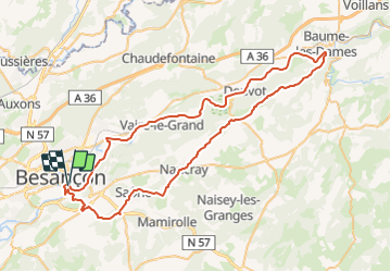
![](/images/other/stat-length.png)
![Tocht Fiets Besançon - Les Villages comtois - Doubs - Photo](https://media.geolcdn.com/t/1900/400/ext.pjpeg?maxdim=2&url=https%3A%2F%2Fservices.sitytrail.com%2FGeolivesWS%2FDownloadMedia.ashx%3FTrailID%3D109423%26Media%3D3771_1.jpg)
Les Villages comtois - Doubs
tracegps
Gebruiker
![Lengte](/images/other/stat-length.png)
![Max. hoogte](https://static1.geolcdn.com/siteimages/upload/files/1508320355ic_sort_altitude_max_24dp.png)
![Positief hoogteverschil](https://static1.geolcdn.com/siteimages/upload/files/1508320355ic_sort_den_pos_24dp.png)
![Km-Effort](/images/other/stat-length.png)
![Min. hoogte](https://static1.geolcdn.com/siteimages/upload/files/1508320355ic_sort_altitude_min_24dp.png)
![Negatief hoogteverschil](https://static1.geolcdn.com/siteimages/upload/files/1508320355ic_sort_den_neg_24dp.png)
![Boucle](https://static1.geolcdn.com/siteimages/upload/files/16400158638029165_repeat_loop_refresh_sync_direction_icon.png)
![Fiets](https://static1.geolcdn.com/sitytour/trail-icons/200.png)
3h15
Moeilijkheid : Medium
![Scan deze QR-code om de tocht te openen in de SityTrail-applicatie](https://capi.geolives.com/qq0zvz2zws4bq2lad0pu/sitytour/trails/109423/qr.png?size=200)
Gratisgps-wandelapplicatie
Over ons
Tocht Fiets van 73 km beschikbaar op Bourgondië-Franche-Comté, Doubs, Besançon. Deze tocht wordt voorgesteld door tracegps.
Beschrijving
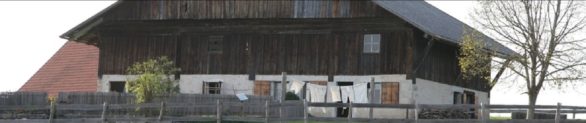
Le Doubs, réserve naturelle d’idées neuves ! Les Villages comtois Office de tourisme à Besançon (03 81 80 92 55), Cité patrimoine, Ville d’Art et d’Histoire - Citadelle de Vauban (03 81 87 83 33), musées, jardin zoologique… - Musée du Temps (03 81 87 81 50) - Musée des Beaux arts et d’Archéologie (03 81 87 80 49) - Horloge astronomique - Visite de la ville en bateaux-mouches - Nombreux belvédères A proximité : Sources d’Arcier Château (XVIIIe) et jardins à la Française (03 81 81 37 18) à Vaire-le-Grand Office de tourisme à Baume-les-Dames (03 81 84 27 98) - Maison des Sires de Neufchâtel (03 81 84 27 98) - Le Jouffroy, bateaux et croisières touristiques (03 81 84 07 99) - Site carrier A proximité : Sources et vallée du Cusancin Musée de plein air des Maisons comtoises (03 81 55 29 77) à Nancray : une trentaine de maisons rurales remontées pierre par pierre et meublées dans un parc de 15 hectares Marais de Saône Chapelle des Buis, Monument de la Libération, panorama sur la ville de Besançon - EuroVélo 6 Nantes-Budapest (135 km d’itinéraires à vélo/rollers… le long du Doubs de Saint-Vit à Allenjoie)
Plaatsbepaling
Opmerkingen
Wandeltochten in de omgeving
![Tocht Stappen Beure - Beure de la pisseur au mercureau - Photo](https://media.geolcdn.com/t/375/260/af87c349-0861-4e70-9a13-b157a632bd51.jpg&format=jpg&maxdim=2)
![Stappen Stappen](https://static1.geolcdn.com/sitytour/trail-icons/101.png)
Stappen
![](/images/other/stat-length.png)
![](https://static1.geolcdn.com/siteimages/upload/files/16400158638029165_repeat_loop_refresh_sync_direction_icon.png)
![Tocht Stappen Beure -](https://media.geolcdn.com/t/375/260/1d465e36-f50c-4143-b089-4392e69daccf.jpg&format=jpg&maxdim=2)
![Stappen Stappen](https://static1.geolcdn.com/sitytour/trail-icons/101.png)
Stappen
![](/images/other/stat-length.png)
![](https://static1.geolcdn.com/siteimages/upload/files/16400158638029165_repeat_loop_refresh_sync_direction_icon.png)
![Tocht Stappen Beure - Beure, fort Planoise, Valmy, Roche trouée, vieille église. - Photo](https://media.geolcdn.com/t/375/260/f17b22e5-5227-4f08-8b37-03856be840af.jpg&format=jpg&maxdim=2)
![Stappen Stappen](https://static1.geolcdn.com/sitytour/trail-icons/101.png)
Stappen
![](/images/other/stat-length.png)
![](https://static1.geolcdn.com/siteimages/upload/files/16400158638029165_repeat_loop_refresh_sync_direction_icon.png)
![Tocht Stappen Montfaucon - Du chateau au fort de Monfaucon - Photo](https://media.geolcdn.com/t/375/260/ext.jpg?maxdim=2&url=https%3A%2F%2Fservices.sitytrail.com%2FGeolivesWS%2FDownloadMedia.ashx%3FTrailID%3D705744%26Media%3Dfix__20170226154846.jpg)
![Stappen Stappen](https://static1.geolcdn.com/sitytour/trail-icons/101.png)
Stappen
![](/images/other/stat-length.png)
![](https://static1.geolcdn.com/siteimages/upload/files/16400158638029165_repeat_loop_refresh_sync_direction_icon.png)
![Tocht Stappen Besançon - Colline de Besançon 29-08-2020 - Photo](https://media.geolcdn.com/t/375/260/1e155548-d400-46d3-8b28-207c9933a379.jpg&format=jpg&maxdim=2)
![Stappen Stappen](https://static1.geolcdn.com/sitytour/trail-icons/101.png)
Stappen
![](/images/other/stat-length.png)
![](https://static1.geolcdn.com/siteimages/upload/files/16400158638029165_repeat_loop_refresh_sync_direction_icon.png)
![Tocht Stappen Fontain - fontain - fort de Fontain - forêt de Fontain - Photo](https://media.geolcdn.com/t/375/260/dda8671d-de1b-4872-afba-e5376a2d57f0.jpg&format=jpg&maxdim=2)
![Stappen Stappen](https://static1.geolcdn.com/sitytour/trail-icons/101.png)
Stappen
![](/images/other/stat-length.png)
![](https://static1.geolcdn.com/siteimages/upload/files/16400158638029165_repeat_loop_refresh_sync_direction_icon.png)
![Tocht Te voet Montfaucon - Boucle de Nacra - Photo](https://media.geolcdn.com/t/375/260/754b99f9-55b9-4375-839c-408b044dfd0e.jpeg&format=jpg&maxdim=2)
![Te voet Te voet](https://static1.geolcdn.com/sitytour/trail-icons/100.png)
Te voet
![](/images/other/stat-length.png)
![](https://static1.geolcdn.com/siteimages/upload/files/16400158638029165_repeat_loop_refresh_sync_direction_icon.png)
![Tocht Te voet Montfaucon - Sentier des Falaises et du château - Photo](https://media.geolcdn.com/t/375/260/5325d98d-322b-4b71-b21b-224d670c2150.jpeg&format=jpg&maxdim=2)
![Te voet Te voet](https://static1.geolcdn.com/sitytour/trail-icons/100.png)
Te voet
![](/images/other/stat-length.png)
![](https://static1.geolcdn.com/siteimages/upload/files/16400158638029165_repeat_loop_refresh_sync_direction_icon.png)
![Tocht Te voet Montfaucon - Sentier du Fort et des Batteries - Photo](https://media.geolcdn.com/t/375/260/465eae89-7ad3-4616-8710-419d54be2030.jpeg&format=jpg&maxdim=2)
![Te voet Te voet](https://static1.geolcdn.com/sitytour/trail-icons/100.png)
Te voet
![](/images/other/stat-length.png)
![](https://static1.geolcdn.com/siteimages/upload/files/16400158638029165_repeat_loop_refresh_sync_direction_icon.png)