![](/images/other/stat-length.png)
![Tocht Stappen Meregem - Circuit des rivières - Merville - Photo](https://media.geolcdn.com/t/1900/400/ext.pjpeg?maxdim=2&url=https%3A%2F%2Fservices.sitytrail.com%2FGeolivesWS%2FDownloadMedia.ashx%3FTrailID%3D109344%26Media%3D3611_6.jpg)
Circuit des rivières - Merville
tracegps
Gebruiker
![Lengte](/images/other/stat-length.png)
Lengte
16,7 km
![Max. hoogte](https://static1.geolcdn.com/siteimages/upload/files/1508320355ic_sort_altitude_max_24dp.png)
Max. hoogte
30 m
![Positief hoogteverschil](https://static1.geolcdn.com/siteimages/upload/files/1508320355ic_sort_den_pos_24dp.png)
Positief hoogteverschil
73 m
![Km-Effort](/images/other/stat-length.png)
Km-Effort
17,6 km
![Min. hoogte](https://static1.geolcdn.com/siteimages/upload/files/1508320355ic_sort_altitude_min_24dp.png)
Min. hoogte
13 m
![Negatief hoogteverschil](https://static1.geolcdn.com/siteimages/upload/files/1508320355ic_sort_den_neg_24dp.png)
Negatief hoogteverschil
74 m
![Boucle](https://static1.geolcdn.com/siteimages/upload/files/16400158638029165_repeat_loop_refresh_sync_direction_icon.png)
Boucle
Ja
Datum van aanmaak :
2014-12-10 00:00:00.0
Laatste wijziging :
2014-12-10 00:00:00.0
![Stappen](https://static1.geolcdn.com/sitytour/trail-icons/101.png)
4h15
Moeilijkheid : Moeilijk
![Scan deze QR-code om de tocht te openen in de SityTrail-applicatie](https://capi.geolives.com/qq0zvz2zws4bq2lad0pu/sitytour/trails/109344/qr.png?size=200)
Gratisgps-wandelapplicatie
Over ons
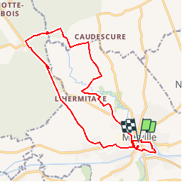
Tocht Stappen van 16,7 km beschikbaar op Hauts-de-France, Noorderdepartement, Meregem. Deze tocht wordt voorgesteld door tracegps.
Beschrijving
Départ de la mairie de Merville. Sur ce circuit se succèdent les petites routes, les chemins agricoles et les lisières de forêts. Retrouvez cette randonnée sur le site du Comité Départemental du Tourisme du Nord.
Plaatsbepaling
Land:
France
Regio :
Hauts-de-France
Departement/Provincie :
Noorderdepartement
Gemeente :
Meregem
Locatie:
Unknown
Vertrek:(Dec)
Vertrek:(UTM)
474419 ; 5610111 (31U) N.
Opmerkingen
Wandeltochten in de omgeving
![Tocht Stappen De Gorge - Chemin de randonnée des Magots (Version longue) - La Gorgue - Photo](https://media.geolcdn.com/t/375/260/ext.jpg?maxdim=2&url=https%3A%2F%2Fservices.sitytrail.com%2FGeolivesWS%2FDownloadMedia.ashx%3FTrailID%3D129826%26Media%3D13377_5.jpg)
![Stappen Stappen](https://static1.geolcdn.com/sitytour/trail-icons/101.png)
Chemin de randonnée des Magots (Version longue) - La Gorgue
Stappen
Moeilijk
(1)
De Gorge,
Hauts-de-France,
Noorderdepartement,
France
![](/images/other/stat-length.png)
13,7 km | 14,3 km-effort
3h 25min
![](https://static1.geolcdn.com/siteimages/upload/files/16400158638029165_repeat_loop_refresh_sync_direction_icon.png)
Ja
![Tocht Stappen De Gorge - Chemin de randonnée des Magots (Version Courte) - La Gorgue - Photo](https://media.geolcdn.com/t/375/260/ext.jpg?maxdim=2&url=https%3A%2F%2Fservices.sitytrail.com%2FGeolivesWS%2FDownloadMedia.ashx%3FTrailID%3D129825%26Media%3D13376_5.jpg)
![Stappen Stappen](https://static1.geolcdn.com/sitytour/trail-icons/101.png)
Chemin de randonnée des Magots (Version Courte) - La Gorgue
Stappen
Gemakkelijk
De Gorge,
Hauts-de-France,
Noorderdepartement,
France
![](/images/other/stat-length.png)
6,2 km | 6,5 km-effort
1h 30min
![](https://static1.geolcdn.com/siteimages/upload/files/16400158638029165_repeat_loop_refresh_sync_direction_icon.png)
Ja
![Stappen Stappen](https://static1.geolcdn.com/sitytour/trail-icons/101.png)
Lestrem des calvaires et chapelles 12 km
Stappen
Gemakkelijk
De Stroom,
Hauts-de-France,
Pas-de-Calais,
France
![](/images/other/stat-length.png)
12,2 km | 12,8 km-effort
17min
![](https://static1.geolcdn.com/siteimages/upload/files/16400158638029165_repeat_loop_refresh_sync_direction_icon.png)
Ja
![Tocht Stappen De Stroom - lestrem benb 13.11.2022 - Photo](https://media.geolcdn.com/t/375/260/8963e277-9835-43ac-88be-a7b70e17a1e2.jpg&format=jpg&maxdim=2)
![Stappen Stappen](https://static1.geolcdn.com/sitytour/trail-icons/101.png)
lestrem benb 13.11.2022
Stappen
Moeilijk
De Stroom,
Hauts-de-France,
Pas-de-Calais,
France
![](/images/other/stat-length.png)
11,6 km | 12,2 km-effort
2h 36min
![](https://static1.geolcdn.com/siteimages/upload/files/16400158638029165_repeat_loop_refresh_sync_direction_icon.png)
Ja
![Tocht Stappen Moerbeke - En passant par Caudescure - Photo](https://media.geolcdn.com/t/375/260/ext.jpg?maxdim=2&url=https%3A%2F%2Fstatic1.geolcdn.com%2Fsiteimages%2Fupload%2Ffiles%2F1553511878bg_sport_marche.png)
![Stappen Stappen](https://static1.geolcdn.com/sitytour/trail-icons/101.png)
En passant par Caudescure
Stappen
Moeilijk
Moerbeke,
Hauts-de-France,
Noorderdepartement,
France
![](/images/other/stat-length.png)
12,4 km | 13,5 km-effort
3h 3min
![](https://static1.geolcdn.com/siteimages/upload/files/16400158638029165_repeat_loop_refresh_sync_direction_icon.png)
Ja
![Tocht Noords wandelen Meregem - Merville, au fil de l'eau - Photo](https://media.geolcdn.com/t/375/260/ext.jpg?maxdim=2&url=https%3A%2F%2Fstatic1.geolcdn.com%2Fsiteimages%2Fupload%2Ffiles%2F1545311037marcheuse_200dpi.jpg)
![Noords wandelen Noords wandelen](https://static1.geolcdn.com/sitytour/trail-icons/102.png)
Merville, au fil de l'eau
Noords wandelen
Gemakkelijk
Meregem,
Hauts-de-France,
Noorderdepartement,
France
![](/images/other/stat-length.png)
4,2 km | 4,5 km-effort
55min
![](https://static1.geolcdn.com/siteimages/upload/files/16400158638029165_repeat_loop_refresh_sync_direction_icon.png)
Ja
![Tocht Stappen De Stroom - 12km La Fosse à Lestrem - Photo](https://media.geolcdn.com/t/375/260/ext.jpg?maxdim=2&url=https%3A%2F%2Fstatic1.geolcdn.com%2Fsiteimages%2Fupload%2Ffiles%2F1553511878bg_sport_marche.png)
![Stappen Stappen](https://static1.geolcdn.com/sitytour/trail-icons/101.png)
12km La Fosse à Lestrem
Stappen
Heel gemakkelijk
De Stroom,
Hauts-de-France,
Pas-de-Calais,
France
![](/images/other/stat-length.png)
11,9 km | 12,5 km-effort
2h 50min
![](https://static1.geolcdn.com/siteimages/upload/files/16400158638029165_repeat_loop_refresh_sync_direction_icon.png)
Ja
![Tocht Stappen Saint-Floris - Saint Floris LO - Photo](https://media.geolcdn.com/t/375/260/ext.jpg?maxdim=2&url=https%3A%2F%2Fstatic1.geolcdn.com%2Fsiteimages%2Fupload%2Ffiles%2F1553511878bg_sport_marche.png)
![Stappen Stappen](https://static1.geolcdn.com/sitytour/trail-icons/101.png)
Saint Floris LO
Stappen
Medium
Saint-Floris,
Hauts-de-France,
Pas-de-Calais,
France
![](/images/other/stat-length.png)
10,1 km | 10,7 km-effort
2h 7min
![](https://static1.geolcdn.com/siteimages/upload/files/16400158638029165_repeat_loop_refresh_sync_direction_icon.png)
Ja
![Tocht Auto Nieuw-Berkijn - es3 5 - Photo](https://media.geolcdn.com/t/375/260/ext.jpg?maxdim=2&url=https%3A%2F%2Fstatic1.geolcdn.com%2Fsiteimages%2Fupload%2Ffiles%2F15247431544x4.jpg)
![Auto Auto](https://static1.geolcdn.com/sitytour/trail-icons/401.png)
es3 5
Auto
Heel gemakkelijk
Nieuw-Berkijn,
Hauts-de-France,
Noorderdepartement,
France
![](/images/other/stat-length.png)
8,6 km | 9,1 km-effort
10min
![](https://static1.geolcdn.com/siteimages/upload/files/16400158638029165_repeat_loop_refresh_sync_direction_icon.png)
Neen
berrias