![](/images/other/stat-length.png)
![Tocht Fiets Langres - Boucle 1 autour de la Voie Verte - Langres - Photo](https://media.geolcdn.com/t/1900/400/ext.pjpeg?maxdim=2&url=https%3A%2F%2Fservices.sitytrail.com%2FGeolivesWS%2FDownloadMedia.ashx%3FTrailID%3D109253%26Media%3D3357_1.jpg)
Boucle 1 autour de la Voie Verte - Langres
tracegps
Gebruiker
![Lengte](/images/other/stat-length.png)
![Max. hoogte](https://static1.geolcdn.com/siteimages/upload/files/1508320355ic_sort_altitude_max_24dp.png)
![Positief hoogteverschil](https://static1.geolcdn.com/siteimages/upload/files/1508320355ic_sort_den_pos_24dp.png)
![Km-Effort](/images/other/stat-length.png)
![Min. hoogte](https://static1.geolcdn.com/siteimages/upload/files/1508320355ic_sort_altitude_min_24dp.png)
![Negatief hoogteverschil](https://static1.geolcdn.com/siteimages/upload/files/1508320355ic_sort_den_neg_24dp.png)
![Boucle](https://static1.geolcdn.com/siteimages/upload/files/16400158638029165_repeat_loop_refresh_sync_direction_icon.png)
![Fiets](https://static1.geolcdn.com/sitytour/trail-icons/200.png)
1h15
Moeilijkheid : Medium
![Scan deze QR-code om de tocht te openen in de SityTrail-applicatie](https://capi.geolives.com/qq0zvz2zws4bq2lad0pu/sitytour/trails/109253/qr.png?size=200)
Gratisgps-wandelapplicatie
Over ons
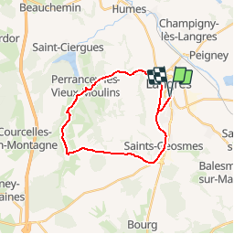
Tocht Fiets van 23 km beschikbaar op Grand Est, Haute-Marne, Langres. Deze tocht wordt voorgesteld door tracegps.
Beschrijving
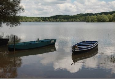
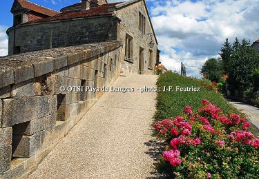
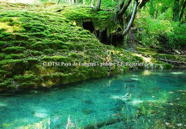
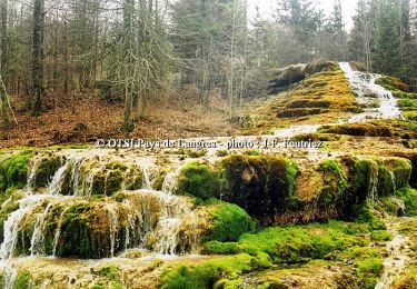
Office de Tourisme du Pays de Langres La Voie Verte vous fera profiter de cette généreuse nature aux portes même de la Ville de Langres. De la vallée de la Bonnelle aux coteaux du plateau de Langres, cette piste cyclable vous accueillera pour votre plus grand plaisir. La fiche est téléchargeable ICI Nota : Les données de l'OT du Pays de Langres sont officielles et restent la référence; toute différence dans le kilométrage provient d'un décalage de calcul entre les différents logiciels.
Plaatsbepaling
Opmerkingen
Wandeltochten in de omgeving
![Tocht Stappen Saints-Geosmes - Boucle 18 km incluant Cohons et la source de la Marne - Photo](https://media.geolcdn.com/t/375/260/3d422adb-0816-44ed-9f3d-740131f7ee60.jpg&format=jpg&maxdim=2)
![Stappen Stappen](https://static1.geolcdn.com/sitytour/trail-icons/101.png)
Stappen
![](/images/other/stat-length.png)
![](https://static1.geolcdn.com/siteimages/upload/files/16400158638029165_repeat_loop_refresh_sync_direction_icon.png)
![Tocht Stappen Humes-Jorquenay - Boucle 26 km autour de Humes - Photo](https://media.geolcdn.com/t/375/260/cf6c3e45-eb31-488c-9d40-076bc7c5c86d.jpg&format=jpg&maxdim=2)
![Stappen Stappen](https://static1.geolcdn.com/sitytour/trail-icons/101.png)
Stappen
![](/images/other/stat-length.png)
![](https://static1.geolcdn.com/siteimages/upload/files/16400158638029165_repeat_loop_refresh_sync_direction_icon.png)
![Tocht Stappen Langres - Boucle 32 km autour de Langres - Photo](https://media.geolcdn.com/t/375/260/0bf94ea6-f335-44d7-a6b3-b3c8b14da8e8.jpg&format=jpg&maxdim=2)
![Stappen Stappen](https://static1.geolcdn.com/sitytour/trail-icons/101.png)
Stappen
![](/images/other/stat-length.png)
![](https://static1.geolcdn.com/siteimages/upload/files/16400158638029165_repeat_loop_refresh_sync_direction_icon.png)
![Tocht Hybride fiets Peigney - Tour du lac de la Liez et passage par le lac de Charmes - Photo](https://media.geolcdn.com/t/375/260/a1d478fc-b921-4ce3-96bc-b97db68855e0.jpg&format=jpg&maxdim=2)
![Hybride fiets Hybride fiets](https://static1.geolcdn.com/sitytour/trail-icons/203.png)
Hybride fiets
![](/images/other/stat-length.png)
![](https://static1.geolcdn.com/siteimages/upload/files/16400158638029165_repeat_loop_refresh_sync_direction_icon.png)
![Tocht Mountainbike Peigney - Tour du lac de la Liez - Langres - Photo](https://media.geolcdn.com/t/375/260/ext.jpg?maxdim=2&url=https%3A%2F%2Fservices.sitytrail.com%2FGeolivesWS%2FDownloadMedia.ashx%3FTrailID%3D215034%26Media%3D15600_6.jpg)
![Mountainbike Mountainbike](https://static1.geolcdn.com/sitytour/trail-icons/202.png)
Mountainbike
![](/images/other/stat-length.png)
![](https://static1.geolcdn.com/siteimages/upload/files/16400158638029165_repeat_loop_refresh_sync_direction_icon.png)
![Tocht Stappen Peigney - Tour du lac de la Liez - Langres - Photo](https://media.geolcdn.com/t/375/260/ext.jpg?maxdim=2&url=https%3A%2F%2Fservices.sitytrail.com%2FGeolivesWS%2FDownloadMedia.ashx%3FTrailID%3D215033%26Media%3D15600_6.jpg)
![Stappen Stappen](https://static1.geolcdn.com/sitytour/trail-icons/101.png)
Stappen
![](/images/other/stat-length.png)
![](https://static1.geolcdn.com/siteimages/upload/files/16400158638029165_repeat_loop_refresh_sync_direction_icon.png)
![Tocht Fiets Langres - Tour des 4 lacs - Langres - Photo](https://media.geolcdn.com/t/375/260/ext.jpg?maxdim=2&url=https%3A%2F%2Fservices.sitytrail.com%2FGeolivesWS%2FDownloadMedia.ashx%3FTrailID%3D109263%26Media%3D3367_5.jpg)
![Fiets Fiets](https://static1.geolcdn.com/sitytour/trail-icons/200.png)
Fiets
![](/images/other/stat-length.png)
![](https://static1.geolcdn.com/siteimages/upload/files/16400158638029165_repeat_loop_refresh_sync_direction_icon.png)
![Tocht Fiets Peigney - Entre Lacs et Canal - Lac de la Liez - Photo](https://media.geolcdn.com/t/375/260/ext.jpg?maxdim=2&url=https%3A%2F%2Fservices.sitytrail.com%2FGeolivesWS%2FDownloadMedia.ashx%3FTrailID%3D109257%26Media%3D3361_5.jpg)
![Fiets Fiets](https://static1.geolcdn.com/sitytour/trail-icons/200.png)
Fiets
![](/images/other/stat-length.png)
![](https://static1.geolcdn.com/siteimages/upload/files/16400158638029165_repeat_loop_refresh_sync_direction_icon.png)
![Tocht Fiets Langres - Entre Plateau de Langres et Montagne - Photo](https://media.geolcdn.com/t/375/260/ext.jpg?maxdim=2&url=https%3A%2F%2Fservices.sitytrail.com%2FGeolivesWS%2FDownloadMedia.ashx%3FTrailID%3D109251%26Media%3D3353_5.jpg)
![Fiets Fiets](https://static1.geolcdn.com/sitytour/trail-icons/200.png)
Fiets
![](/images/other/stat-length.png)
![](https://static1.geolcdn.com/siteimages/upload/files/16400158638029165_repeat_loop_refresh_sync_direction_icon.png)
Pas trop de passage de voiture, fait avec un enfant de 2 ans 1/2 dans le siège bébé, parcours sympa!