![](/images/other/stat-length.png)
![Tocht Stappen Dehlingen - DehlingenRahling - Photo](https://media.geolcdn.com/t/1900/400/ext.pjpeg?maxdim=2&url=https%3A%2F%2Fservices.sitytrail.com%2FGeolivesWS%2FDownloadMedia.ashx%3FTrailID%3D1092058%26Media%3Dfix__20181229151503.jpg)
DehlingenRahling
helmut68
Gebruiker
![Lengte](/images/other/stat-length.png)
Lengte
12,5 km
![Max. hoogte](https://static1.geolcdn.com/siteimages/upload/files/1508320355ic_sort_altitude_max_24dp.png)
Max. hoogte
355 m
![Positief hoogteverschil](https://static1.geolcdn.com/siteimages/upload/files/1508320355ic_sort_den_pos_24dp.png)
Positief hoogteverschil
180 m
![Km-Effort](/images/other/stat-length.png)
Km-Effort
14,9 km
![Min. hoogte](https://static1.geolcdn.com/siteimages/upload/files/1508320355ic_sort_altitude_min_24dp.png)
Min. hoogte
242 m
![Negatief hoogteverschil](https://static1.geolcdn.com/siteimages/upload/files/1508320355ic_sort_den_neg_24dp.png)
Negatief hoogteverschil
183 m
![Boucle](https://static1.geolcdn.com/siteimages/upload/files/16400158638029165_repeat_loop_refresh_sync_direction_icon.png)
Boucle
Ja
Datum van aanmaak :
2019-01-15 20:26:25.346
Laatste wijziging :
2019-01-15 20:26:25.346
![Stappen](https://static1.geolcdn.com/sitytour/trail-icons/101.png)
3h01
Moeilijkheid : Gemakkelijk
![Scan deze QR-code om de tocht te openen in de SityTrail-applicatie](https://capi.geolives.com/qq0zvz2zws4bq2lad0pu/sitytour/trails/1092058/qr.png?size=200)
Gratisgps-wandelapplicatie
Over ons
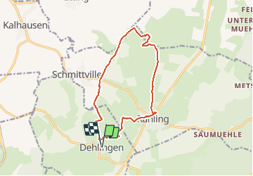
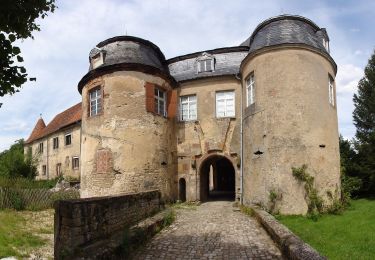
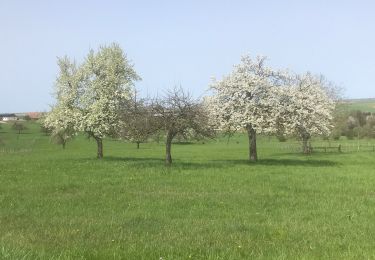
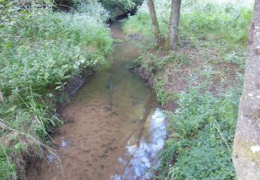
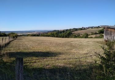
Tocht Stappen van 12,5 km beschikbaar op Grand Est, Bas-Rhin, Dehlingen. Deze tocht wordt voorgesteld door helmut68.
Beschrijving
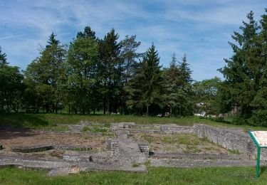
Départ fontaine de Dehlingen, direction Schmittwiller jusqu'au château d'eau,prendre le chemin en face jusqu'au Mohrenhof,puis la chapelle d'Altkich, ensuite Rahling et pour finir rejoindre Dehlingen par les fouilles romaines.
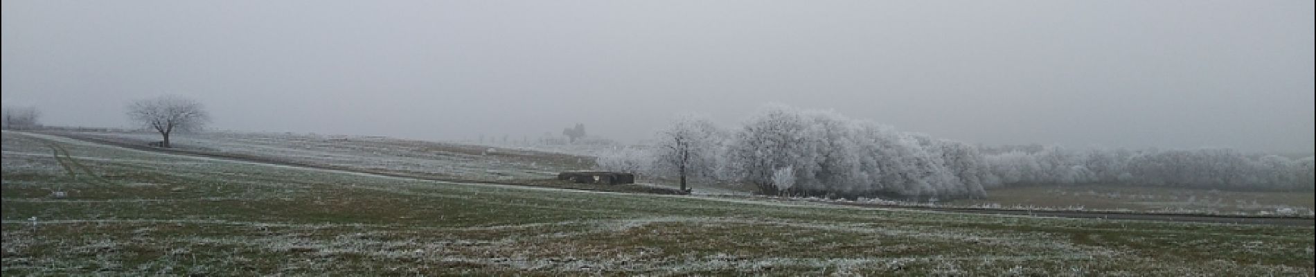
Ballade agréable avec de très belles vues ...
Plaatsbepaling
Land:
France
Regio :
Grand Est
Departement/Provincie :
Bas-Rhin
Gemeente :
Dehlingen
Locatie:
Unknown
Vertrek:(Dec)
Vertrek:(UTM)
367756 ; 5427033 (32U) N.
Opmerkingen
Wandeltochten in de omgeving
![Tocht Te voet Diemeringen - Mackwiller la romaine - Photo](https://media.geolcdn.com/t/375/260/6e42945c-7f24-4443-aff5-37264c5394f0.jpeg&format=jpg&maxdim=2)
![Te voet Te voet](https://static1.geolcdn.com/sitytour/trail-icons/100.png)
Mackwiller la romaine
Te voet
Gemakkelijk
Diemeringen,
Grand Est,
Bas-Rhin,
France
![](/images/other/stat-length.png)
4,6 km | 5,4 km-effort
1h 14min
![](https://static1.geolcdn.com/siteimages/upload/files/16400158638029165_repeat_loop_refresh_sync_direction_icon.png)
Ja
![Tocht Te voet Diemeringen - Croix bleue - Photo](https://media.geolcdn.com/t/375/260/038b5fbd-ad7d-4d8f-a6b9-4f60e8eebeb8.jpeg&format=jpg&maxdim=2)
![Te voet Te voet](https://static1.geolcdn.com/sitytour/trail-icons/100.png)
Croix bleue
Te voet
Gemakkelijk
Diemeringen,
Grand Est,
Bas-Rhin,
France
![](/images/other/stat-length.png)
12,3 km | 16,1 km-effort
3h 39min
![](https://static1.geolcdn.com/siteimages/upload/files/16400158638029165_repeat_loop_refresh_sync_direction_icon.png)
Neen
![Tocht Te voet Diemeringen - Triangle bleu - Photo](https://media.geolcdn.com/t/375/260/d4b9e7be-1430-47f3-af7c-96cdacf9298e.jpeg&format=jpg&maxdim=2)
![Te voet Te voet](https://static1.geolcdn.com/sitytour/trail-icons/100.png)
Triangle bleu
Te voet
Gemakkelijk
Diemeringen,
Grand Est,
Bas-Rhin,
France
![](/images/other/stat-length.png)
7,6 km | 9,6 km-effort
2h 10min
![](https://static1.geolcdn.com/siteimages/upload/files/16400158638029165_repeat_loop_refresh_sync_direction_icon.png)
Neen
![Tocht Te voet Diemeringen - Comtesse Sophie de Nassau - Photo](https://media.geolcdn.com/t/375/260/8c2b8556-e0a8-4065-811c-0a8a71e07fa2.jpeg&format=jpg&maxdim=2)
![Te voet Te voet](https://static1.geolcdn.com/sitytour/trail-icons/100.png)
Comtesse Sophie de Nassau
Te voet
Gemakkelijk
Diemeringen,
Grand Est,
Bas-Rhin,
France
![](/images/other/stat-length.png)
6,9 km | 8,1 km-effort
1h 50min
![](https://static1.geolcdn.com/siteimages/upload/files/16400158638029165_repeat_loop_refresh_sync_direction_icon.png)
Ja
![Tocht Te voet Diemeringen - Yellow triangle - Photo](https://media.geolcdn.com/t/375/260/d4b9e7be-1430-47f3-af7c-96cdacf9298e.jpeg&format=jpg&maxdim=2)
![Te voet Te voet](https://static1.geolcdn.com/sitytour/trail-icons/100.png)
Yellow triangle
Te voet
Medium
Diemeringen,
Grand Est,
Bas-Rhin,
France
![](/images/other/stat-length.png)
21 km | 27 km-effort
6h 11min
![](https://static1.geolcdn.com/siteimages/upload/files/16400158638029165_repeat_loop_refresh_sync_direction_icon.png)
Neen
![Tocht sport Butten - 2024-04-07 Les vergers de Butten - Photo](https://media.geolcdn.com/t/375/260/21e8b322-75c7-495e-aaf5-acea1f138e8c.jpg&format=jpg&maxdim=2)
2024-04-07 Les vergers de Butten
sport
Heel gemakkelijk
Butten,
Grand Est,
Bas-Rhin,
France
![](/images/other/stat-length.png)
4,3 km | 5,5 km-effort
Onbekend
![](https://static1.geolcdn.com/siteimages/upload/files/16400158638029165_repeat_loop_refresh_sync_direction_icon.png)
Ja
![Tocht Stappen Dehlingen - Speckfest Dehlingen 2023 - Photo](https://media.geolcdn.com/t/375/260/50343618-1039-4cc2-8cba-88bb57992e6e.jpg&format=jpg&maxdim=2)
![Stappen Stappen](https://static1.geolcdn.com/sitytour/trail-icons/101.png)
Speckfest Dehlingen 2023
Stappen
Gemakkelijk
Dehlingen,
Grand Est,
Bas-Rhin,
France
![](/images/other/stat-length.png)
4,8 km | 6,2 km-effort
1h 10min
![](https://static1.geolcdn.com/siteimages/upload/files/16400158638029165_repeat_loop_refresh_sync_direction_icon.png)
Ja
![Tocht Te voet Ratzwiller - Chevalet vert - Photo](https://media.geolcdn.com/t/375/260/e1ca6c5c-ec16-4e6c-a9bf-b3aef84f04a4.jpeg&format=jpg&maxdim=2)
![Te voet Te voet](https://static1.geolcdn.com/sitytour/trail-icons/100.png)
Chevalet vert
Te voet
Gemakkelijk
Ratzwiller,
Grand Est,
Bas-Rhin,
France
![](/images/other/stat-length.png)
6,1 km | 8,2 km-effort
1h 51min
![](https://static1.geolcdn.com/siteimages/upload/files/16400158638029165_repeat_loop_refresh_sync_direction_icon.png)
Neen
![Tocht Stappen Dehlingen - Dehlingen Remelfing - Photo](https://media.geolcdn.com/t/375/260/4e1a1449-9bb3-41eb-9ea3-e127d0b3e233.jpg&format=jpg&maxdim=2)
![Stappen Stappen](https://static1.geolcdn.com/sitytour/trail-icons/101.png)
Dehlingen Remelfing
Stappen
Gemakkelijk
Dehlingen,
Grand Est,
Bas-Rhin,
France
![](/images/other/stat-length.png)
22 km | 27 km-effort
4h 32min
![](https://static1.geolcdn.com/siteimages/upload/files/16400158638029165_repeat_loop_refresh_sync_direction_icon.png)
Neen