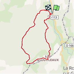
![](/images/other/stat-length.png)
![Tocht Stappen Grane - Boucle pédestre n°43 - Les Micouleaux - Photo](https://media.geolcdn.com/t/1900/400/ext.pjpeg?maxdim=2&url=https%3A%2F%2Fservices.sitytrail.com%2FGeolivesWS%2FDownloadMedia.ashx%3FTrailID%3D109062%26Media%3D3084_1.jpg)
Boucle pédestre n°43 - Les Micouleaux
tracegps
Gebruiker
![Lengte](/images/other/stat-length.png)
![Max. hoogte](https://static1.geolcdn.com/siteimages/upload/files/1508320355ic_sort_altitude_max_24dp.png)
![Positief hoogteverschil](https://static1.geolcdn.com/siteimages/upload/files/1508320355ic_sort_den_pos_24dp.png)
![Km-Effort](/images/other/stat-length.png)
![Min. hoogte](https://static1.geolcdn.com/siteimages/upload/files/1508320355ic_sort_altitude_min_24dp.png)
![Negatief hoogteverschil](https://static1.geolcdn.com/siteimages/upload/files/1508320355ic_sort_den_neg_24dp.png)
![Boucle](https://static1.geolcdn.com/siteimages/upload/files/16400158638029165_repeat_loop_refresh_sync_direction_icon.png)
![Stappen](https://static1.geolcdn.com/sitytour/trail-icons/101.png)
2h45
Moeilijkheid : Medium
![Scan deze QR-code om de tocht te openen in de SityTrail-applicatie](https://capi.geolives.com/qq0zvz2zws4bq2lad0pu/sitytour/trails/109062/qr.png?size=200)
Gratisgps-wandelapplicatie
Over ons
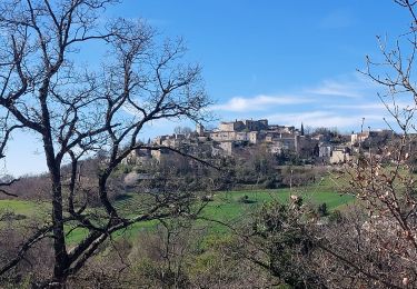
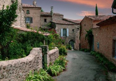
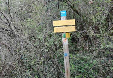
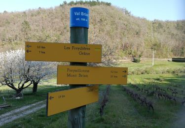
Tocht Stappen van 7,7 km beschikbaar op Auvergne-Rhône-Alpes, Drôme, Grane. Deze tocht wordt voorgesteld door tracegps.
Beschrijving
Les randonnées pédestres de Grâne Rando Loisirs. Le départ est situé sur la route de Roche sur Grâne à 3km environ du Syndicat d’initiative premier chemin à droite après le quartier «Liard»: Traversée du bois des Sensouzes par de beaux sentiers de chevriers, balade toute en douceur. Du «Pont des Sensouzes» à droite vers «Bois de la Dame» par le sentier montant, puis vers «Sensouzes» et «Voie N°2» par le chemin du Bois de la Dame; de là prendre à gauche vers «Serre Jalat» et «Le Fraysse» par un chemin descendant, puis prendre la route en descente jusqu'au hameau «Les Micouleaux», à gauche vers la bergerie et «Le Chaffal», là après la maison remonter dans les bois vers «Les Chaffaux» et «Le Guot», rejoindre le «Pont des Sensouzes» par un joli sentier en passant à proximité d'une chèvrerie. (Numérisation par Joël Vachon)
Plaatsbepaling
Opmerkingen
Wandeltochten in de omgeving
![Tocht Stappen Grane - Grane-Les Roberts 13km - Photo](https://media.geolcdn.com/t/375/260/5618d6af-4205-4e85-865b-a90a6c161a8c.jpg&format=jpg&maxdim=2)
![Stappen Stappen](https://static1.geolcdn.com/sitytour/trail-icons/101.png)
Stappen
![](/images/other/stat-length.png)
![](https://static1.geolcdn.com/siteimages/upload/files/16400158638029165_repeat_loop_refresh_sync_direction_icon.png)
![Tocht Stappen Grane - grane bois de la dame Pierre sanglante - Photo](https://media.geolcdn.com/t/375/260/ext.jpg?maxdim=2&url=https%3A%2F%2Fstatic1.geolcdn.com%2Fsiteimages%2Fupload%2Ffiles%2F1553511878bg_sport_marche.png)
![Stappen Stappen](https://static1.geolcdn.com/sitytour/trail-icons/101.png)
Stappen
![](/images/other/stat-length.png)
![](https://static1.geolcdn.com/siteimages/upload/files/16400158638029165_repeat_loop_refresh_sync_direction_icon.png)
![Tocht Stappen Allex - Balade des Ramieres à livron - Photo](https://media.geolcdn.com/t/375/260/ext.jpg?maxdim=2&url=https%3A%2F%2Fstatic1.geolcdn.com%2Fsiteimages%2Fupload%2Ffiles%2F1553511878bg_sport_marche.png)
![Stappen Stappen](https://static1.geolcdn.com/sitytour/trail-icons/101.png)
Stappen
![](/images/other/stat-length.png)
![](https://static1.geolcdn.com/siteimages/upload/files/16400158638029165_repeat_loop_refresh_sync_direction_icon.png)
![Tocht sport La Roche-sur-Grane - La Roche Sur Grane Pierre sanglante - Photo](https://media.geolcdn.com/t/375/260/00a75b30-e9f2-4ffa-8db5-87cf804557d7.jpg&format=jpg&maxdim=2)
sport
![](/images/other/stat-length.png)
![](https://static1.geolcdn.com/siteimages/upload/files/16400158638029165_repeat_loop_refresh_sync_direction_icon.png)
![Tocht Stappen Autichamp - Autichamp 9Km - Photo](https://media.geolcdn.com/t/375/260/277bf4ea-4835-4fdb-8282-6e16b9963cce.jpg&format=jpg&maxdim=2)
![Stappen Stappen](https://static1.geolcdn.com/sitytour/trail-icons/101.png)
Stappen
![](/images/other/stat-length.png)
![](https://static1.geolcdn.com/siteimages/upload/files/16400158638029165_repeat_loop_refresh_sync_direction_icon.png)
![Tocht Stappen Autichamp - 2022-06-24_19h04m17_Autichamp 16km.gpx.xml - Photo](https://media.geolcdn.com/t/375/260/ff500e8d-e5ee-4913-9cc9-1d2f8dd43576.jpg&format=jpg&maxdim=2)
![Stappen Stappen](https://static1.geolcdn.com/sitytour/trail-icons/101.png)
Stappen
![](/images/other/stat-length.png)
![](https://static1.geolcdn.com/siteimages/upload/files/16400158638029165_repeat_loop_refresh_sync_direction_icon.png)
![Tocht Stappen Grane - De Val Brian au Mont Brian - Photo](https://media.geolcdn.com/t/375/260/bc6d4726-3ae6-481c-b979-5b3a43f540de.jpg&format=jpg&maxdim=2)
![Stappen Stappen](https://static1.geolcdn.com/sitytour/trail-icons/101.png)
Stappen
![](/images/other/stat-length.png)
![](https://static1.geolcdn.com/siteimages/upload/files/16400158638029165_repeat_loop_refresh_sync_direction_icon.png)
![Tocht Stappen Grane - De Val Brian au lac sans nom - Photo](https://media.geolcdn.com/t/375/260/0dfbfd01-b6ba-4eaf-a75e-fcb6bdc5753b.jpg&format=jpg&maxdim=2)
![Stappen Stappen](https://static1.geolcdn.com/sitytour/trail-icons/101.png)
Stappen
![](/images/other/stat-length.png)
![](https://static1.geolcdn.com/siteimages/upload/files/16400158638029165_repeat_loop_refresh_sync_direction_icon.png)
![Tocht Mountainbike Marsanne - la teissoniere/pont de terre - Photo](https://media.geolcdn.com/t/375/260/0397b7c3-e5e0-4702-b911-2c2cdd972419.jpg&format=jpg&maxdim=2)
![Mountainbike Mountainbike](https://static1.geolcdn.com/sitytour/trail-icons/202.png)
Mountainbike
![](/images/other/stat-length.png)
![](https://static1.geolcdn.com/siteimages/upload/files/16400158638029165_repeat_loop_refresh_sync_direction_icon.png)