![](/images/other/stat-length.png)
![Tocht Stappen Halloy-lès-Pernois - Circuit du bois des dames - Photo](https://media.geolcdn.com/t/1900/400/ext.pjpeg?maxdim=2&url=https%3A%2F%2Fservices.sitytrail.com%2FGeolivesWS%2FDownloadMedia.ashx%3FTrailID%3D108842%26Media%3D2386_2.jpg)
Circuit du bois des dames
tracegps
Gebruiker
![Lengte](/images/other/stat-length.png)
Lengte
12 km
![Max. hoogte](https://static1.geolcdn.com/siteimages/upload/files/1508320355ic_sort_altitude_max_24dp.png)
Max. hoogte
81 m
![Positief hoogteverschil](https://static1.geolcdn.com/siteimages/upload/files/1508320355ic_sort_den_pos_24dp.png)
Positief hoogteverschil
123 m
![Km-Effort](/images/other/stat-length.png)
Km-Effort
13,7 km
![Min. hoogte](https://static1.geolcdn.com/siteimages/upload/files/1508320355ic_sort_altitude_min_24dp.png)
Min. hoogte
28 m
![Negatief hoogteverschil](https://static1.geolcdn.com/siteimages/upload/files/1508320355ic_sort_den_neg_24dp.png)
Negatief hoogteverschil
123 m
![Boucle](https://static1.geolcdn.com/siteimages/upload/files/16400158638029165_repeat_loop_refresh_sync_direction_icon.png)
Boucle
Ja
Datum van aanmaak :
2014-12-10 00:00:00.0
Laatste wijziging :
2014-12-10 00:00:00.0
![Stappen](https://static1.geolcdn.com/sitytour/trail-icons/101.png)
4h00
Moeilijkheid : Medium
![Scan deze QR-code om de tocht te openen in de SityTrail-applicatie](https://capi.geolives.com/qq0zvz2zws4bq2lad0pu/sitytour/trails/108842/qr.png?size=200)
Gratisgps-wandelapplicatie
Over ons
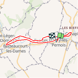
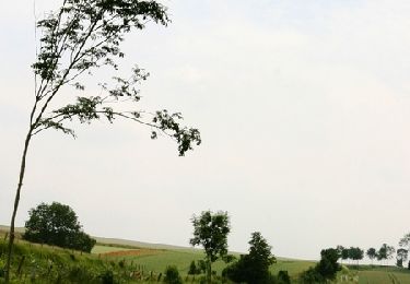
Tocht Stappen van 12 km beschikbaar op Hauts-de-France, Somme, Halloy-lès-Pernois. Deze tocht wordt voorgesteld door tracegps.
Beschrijving
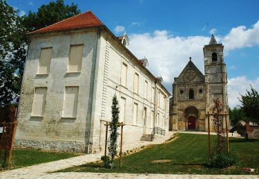
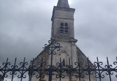
Sur les pas des soeurs bénédictines qui, jadis, quittaient parfois leur abbaye pour rejoindre les bois et sentiers. Pour télécharger la fiche du circuit en format pdf.
Plaatsbepaling
Land:
France
Regio :
Hauts-de-France
Departement/Provincie :
Somme
Gemeente :
Halloy-lès-Pernois
Locatie:
Unknown
Vertrek:(Dec)
Vertrek:(UTM)
442652 ; 5544525 (31U) N.
Opmerkingen
Wandeltochten in de omgeving
![Tocht Te voet Saint-Léger-lès-Domart - Circuit du Bois des Dames - Photo](https://media.geolcdn.com/t/375/260/dad39f03-37d8-4eec-b319-bf262ccd5aeb.jpeg&format=jpg&maxdim=2)
![Te voet Te voet](https://static1.geolcdn.com/sitytour/trail-icons/100.png)
Circuit du Bois des Dames
Te voet
Gemakkelijk
Saint-Léger-lès-Domart,
Hauts-de-France,
Somme,
France
![](/images/other/stat-length.png)
11,5 km | 13,2 km-effort
2h 59min
![](https://static1.geolcdn.com/siteimages/upload/files/16400158638029165_repeat_loop_refresh_sync_direction_icon.png)
Ja
![Tocht Stappen Canaples - Canaples - Photo](https://media.geolcdn.com/t/375/260/26322aab-2314-4460-90b5-2bcd220b5faa.jpg&format=jpg&maxdim=2)
![Stappen Stappen](https://static1.geolcdn.com/sitytour/trail-icons/101.png)
Canaples
Stappen
Medium
Canaples,
Hauts-de-France,
Somme,
France
![](/images/other/stat-length.png)
16,1 km | 19,2 km-effort
3h 57min
![](https://static1.geolcdn.com/siteimages/upload/files/16400158638029165_repeat_loop_refresh_sync_direction_icon.png)
Ja
![Tocht Stappen Canaples - Le Montant Blanc - Canaples - Photo](https://media.geolcdn.com/t/375/260/ext.jpg?maxdim=2&url=https%3A%2F%2Fservices.sitytrail.com%2FGeolivesWS%2FDownloadMedia.ashx%3FTrailID%3D317833%26Media%3D17203_2.jpg)
![Stappen Stappen](https://static1.geolcdn.com/sitytour/trail-icons/101.png)
Le Montant Blanc - Canaples
Stappen
Moeilijk
Canaples,
Hauts-de-France,
Somme,
France
![](/images/other/stat-length.png)
15,3 km | 18,7 km-effort
3h 30min
![](https://static1.geolcdn.com/siteimages/upload/files/16400158638029165_repeat_loop_refresh_sync_direction_icon.png)
Ja
![Tocht Stappen Saint-Léger-lès-Domart - L'arbre de la Croix - Photo](https://media.geolcdn.com/t/375/260/ext.jpg?maxdim=2&url=https%3A%2F%2Fservices.sitytrail.com%2FGeolivesWS%2FDownloadMedia.ashx%3FTrailID%3D108841%26Media%3D2385_2.jpg)
![Stappen Stappen](https://static1.geolcdn.com/sitytour/trail-icons/101.png)
L'arbre de la Croix
Stappen
Medium
Saint-Léger-lès-Domart,
Hauts-de-France,
Somme,
France
![](/images/other/stat-length.png)
6,5 km | 7,9 km-effort
2h 0min
![](https://static1.geolcdn.com/siteimages/upload/files/16400158638029165_repeat_loop_refresh_sync_direction_icon.png)
Ja
![Tocht Te voet Wargnies - Dans la Campagne près des Muches - Photo](https://media.geolcdn.com/t/375/260/ext.jpg?maxdim=2&url=https%3A%2F%2Fstatic1.geolcdn.com%2Fsiteimages%2Fupload%2Ffiles%2F1545311037marcheuse_200dpi.jpg)
![Te voet Te voet](https://static1.geolcdn.com/sitytour/trail-icons/100.png)
Dans la Campagne près des Muches
Te voet
Gemakkelijk
Wargnies,
Hauts-de-France,
Somme,
France
![](/images/other/stat-length.png)
3,8 km | 4,8 km-effort
1h 5min
![](https://static1.geolcdn.com/siteimages/upload/files/16400158638029165_repeat_loop_refresh_sync_direction_icon.png)
Ja
![Tocht Andere activiteiten Canaples - Picardie - Ligne 322 - Canaples - Longroy - Gamaches par Longpré - Photo](https://media.geolcdn.com/t/375/260/ext.jpg?maxdim=2&url=https%3A%2F%2Fstatic1.geolcdn.com%2Fsiteimages%2Fupload%2Ffiles%2F1545311037marcheuse_200dpi.jpg)
![Andere activiteiten Andere activiteiten](https://static1.geolcdn.com/sitytour/trail-icons/900.png)
Picardie - Ligne 322 - Canaples - Longroy - Gamaches par Longpré
Andere activiteiten
Heel gemakkelijk
Canaples,
Hauts-de-France,
Somme,
France
![](/images/other/stat-length.png)
57 km | 62 km-effort
5min
![](https://static1.geolcdn.com/siteimages/upload/files/16400158638029165_repeat_loop_refresh_sync_direction_icon.png)
Neen
![Tocht Mountainbike Vignacourt - VTT Vignacourt - Photo](https://media.geolcdn.com/t/375/260/ext.jpg?maxdim=2&url=https%3A%2F%2Fstatic1.geolcdn.com%2Fsiteimages%2Fupload%2Ffiles%2F1524743154velo.jpg)
![Mountainbike Mountainbike](https://static1.geolcdn.com/sitytour/trail-icons/202.png)
VTT Vignacourt
Mountainbike
Medium
Vignacourt,
Hauts-de-France,
Somme,
France
![](/images/other/stat-length.png)
19,3 km | 22 km-effort
1h 25min
![](https://static1.geolcdn.com/siteimages/upload/files/16400158638029165_repeat_loop_refresh_sync_direction_icon.png)
Ja
![Tocht Paardrijden Wargnies - Jour 2 Equirando - Photo](https://media.geolcdn.com/t/375/260/ext.jpg?maxdim=2&url=https%3A%2F%2Fstatic1.geolcdn.com%2Fsiteimages%2Fupload%2Ffiles%2F1524743154cheval.jpg)
![Paardrijden Paardrijden](https://static1.geolcdn.com/sitytour/trail-icons/301.png)
Jour 2 Equirando
Paardrijden
Medium
Wargnies,
Hauts-de-France,
Somme,
France
![](/images/other/stat-length.png)
21 km | 25 km-effort
3h 39min
![](https://static1.geolcdn.com/siteimages/upload/files/16400158638029165_repeat_loop_refresh_sync_direction_icon.png)
Neen