![](/images/other/stat-length.png)
![Tocht Stappen Labaroche - Les sommets du Gestion et du Cras - Photo](https://media.geolcdn.com/t/1900/400/ext.pjpeg?maxdim=2&url=https%3A%2F%2Fservices.sitytrail.com%2FGeolivesWS%2FDownloadMedia.ashx%3FTrailID%3D108798%26Media%3D2101_6.jpg)
Les sommets du Gestion et du Cras
tracegps
Gebruiker
![Lengte](/images/other/stat-length.png)
![Max. hoogte](https://static1.geolcdn.com/siteimages/upload/files/1508320355ic_sort_altitude_max_24dp.png)
![Positief hoogteverschil](https://static1.geolcdn.com/siteimages/upload/files/1508320355ic_sort_den_pos_24dp.png)
![Km-Effort](/images/other/stat-length.png)
![Min. hoogte](https://static1.geolcdn.com/siteimages/upload/files/1508320355ic_sort_altitude_min_24dp.png)
![Negatief hoogteverschil](https://static1.geolcdn.com/siteimages/upload/files/1508320355ic_sort_den_neg_24dp.png)
![Boucle](https://static1.geolcdn.com/siteimages/upload/files/16400158638029165_repeat_loop_refresh_sync_direction_icon.png)
![Stappen](https://static1.geolcdn.com/sitytour/trail-icons/101.png)
2h00
Moeilijkheid : Gemakkelijk
![Scan deze QR-code om de tocht te openen in de SityTrail-applicatie](https://capi.geolives.com/qq0zvz2zws4bq2lad0pu/sitytour/trails/108798/qr.png?size=200)
Gratisgps-wandelapplicatie
Over ons
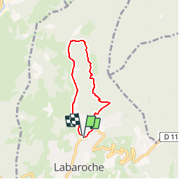
Tocht Stappen van 4,7 km beschikbaar op Grand Est, Haut-Rhin, Labaroche. Deze tocht wordt voorgesteld door tracegps.
Beschrijving
Labaroche est un village de 2000 habitants, situé en Alsace à 20 km de Colmar. Accès par Ammerschwihr, par Turckheim ou Niedermorschwihr via Trois-Epis, ou par Orbey. D'une altitude moyenne de 750 mètres, la commune se trouve sur un plateau à cheval entre la vallée de Kaysersberg et celle de Munster. Les crêtes vosgiennes et la station de ski du Lac Blanc ne sont qu'à 20 km, mais vous trouverez des circuits de randonnées pédestres, à VTT, à cheval ou de ski de fond tout autour du village. Une agréable petite promenade sur les hauteurs boisées situées au nord de Labaroche. La table d’orientation au sommet du Gestion a été réalisée par la classe de CM années 1994 / 1998 de l’école Jean Heim de Labaroche. Table réalisée en plaques de céramique avec l’aide de l’artiste André Edzard. Très belle vue vers les Hautes Chaumes. La table vous donnera des informations très précises sur le panorama. Départ : Labaroche « La Chapelle ». Balisage : chevalet vert – croix jaune.
Plaatsbepaling
Opmerkingen
Wandeltochten in de omgeving
![Tocht Stappen Ammerschwihr - Trois Épis le rocher du corbeau - Photo](https://media.geolcdn.com/t/375/260/dbdb5766-f574-4a80-9cd8-371c84f0061c.jpg&format=jpg&maxdim=2)
![Stappen Stappen](https://static1.geolcdn.com/sitytour/trail-icons/101.png)
Stappen
![](/images/other/stat-length.png)
![](https://static1.geolcdn.com/siteimages/upload/files/16400158638029165_repeat_loop_refresh_sync_direction_icon.png)
![Tocht Mountainbike Labaroche - Tour de Labaroche - Photo](https://media.geolcdn.com/t/375/260/ext.jpg?maxdim=2&url=https%3A%2F%2Fservices.sitytrail.com%2FGeolivesWS%2FDownloadMedia.ashx%3FTrailID%3D172875%26Media%3D14329_1.jpg)
![Mountainbike Mountainbike](https://static1.geolcdn.com/sitytour/trail-icons/202.png)
Mountainbike
![](/images/other/stat-length.png)
![](https://static1.geolcdn.com/siteimages/upload/files/16400158638029165_repeat_loop_refresh_sync_direction_icon.png)
![Tocht Stappen Lapoutroie - 2012-06-16 Marche aux Alisiers Orbey - Photo](https://media.geolcdn.com/t/375/260/ext.jpg?maxdim=2&url=https%3A%2F%2Fstatic1.geolcdn.com%2Fsiteimages%2Fupload%2Ffiles%2F1553511878bg_sport_marche.png)
![Stappen Stappen](https://static1.geolcdn.com/sitytour/trail-icons/101.png)
Stappen
![](/images/other/stat-length.png)
![](https://static1.geolcdn.com/siteimages/upload/files/16400158638029165_repeat_loop_refresh_sync_direction_icon.png)
![Tocht Stappen Kaysersberg-Vignoble - Du ⛺️ aux 4 villages - Photo](https://media.geolcdn.com/t/375/260/47566d1f-1190-42ce-9084-8a92c1b5deab.jpg&format=jpg&maxdim=2)
![Stappen Stappen](https://static1.geolcdn.com/sitytour/trail-icons/101.png)
Stappen
![](/images/other/stat-length.png)
![](https://static1.geolcdn.com/siteimages/upload/files/16400158638029165_repeat_loop_refresh_sync_direction_icon.png)
![Tocht Paardrijden Gunsbach - Le petit Hohnack - verkort (23) - Photo](https://media.geolcdn.com/t/375/260/ext.jpg?maxdim=2&url=https%3A%2F%2Fstatic1.geolcdn.com%2Fsiteimages%2Fupload%2Ffiles%2F1524743154cheval.jpg)
![Paardrijden Paardrijden](https://static1.geolcdn.com/sitytour/trail-icons/301.png)
Paardrijden
![](/images/other/stat-length.png)
![](https://static1.geolcdn.com/siteimages/upload/files/16400158638029165_repeat_loop_refresh_sync_direction_icon.png)
![Tocht Stappen Kaysersberg-Vignoble - 2021-05-30 Marche Kaysersberg Ursprung St Alexis - Photo](https://media.geolcdn.com/t/375/260/4ae16611-5255-49df-be17-2a5aa0e78321.jpg&format=jpg&maxdim=2)
![Stappen Stappen](https://static1.geolcdn.com/sitytour/trail-icons/101.png)
Stappen
![](/images/other/stat-length.png)
![](https://static1.geolcdn.com/siteimages/upload/files/16400158638029165_repeat_loop_refresh_sync_direction_icon.png)
![Tocht Paardrijden Kaysersberg-Vignoble - 2019-10-26 CDTE67 Tournage Video Promotion TE - Photo](https://media.geolcdn.com/t/375/260/d78bcf89-6739-4bcc-854f-0c743f5412b8.jpg&format=jpg&maxdim=2)
![Paardrijden Paardrijden](https://static1.geolcdn.com/sitytour/trail-icons/301.png)
Paardrijden
![](/images/other/stat-length.png)
![](https://static1.geolcdn.com/siteimages/upload/files/16400158638029165_repeat_loop_refresh_sync_direction_icon.png)
![Tocht Stappen Orbey - Orbey-Labaroche - Photo](https://media.geolcdn.com/t/375/260/ext.jpg?maxdim=2&url=https%3A%2F%2Fstatic1.geolcdn.com%2Fsiteimages%2Fupload%2Ffiles%2F1553511878bg_sport_marche.png)
![Stappen Stappen](https://static1.geolcdn.com/sitytour/trail-icons/101.png)
Stappen
![](/images/other/stat-length.png)
![](https://static1.geolcdn.com/siteimages/upload/files/16400158638029165_repeat_loop_refresh_sync_direction_icon.png)
![Tocht Stappen Kaysersberg-Vignoble - Le tour de Kysersberg - Photo](https://media.geolcdn.com/t/375/260/ext.jpg?maxdim=2&url=https%3A%2F%2Fservices.sitytrail.com%2FGeolivesWS%2FDownloadMedia.ashx%3FTrailID%3D482177%26Media%3D9aff239b-2fb3-4dd0-a536-a4dc7a8f2dee.jpg)
![Stappen Stappen](https://static1.geolcdn.com/sitytour/trail-icons/101.png)
Stappen
![](/images/other/stat-length.png)
![](https://static1.geolcdn.com/siteimages/upload/files/16400158638029165_repeat_loop_refresh_sync_direction_icon.png)