![](/images/other/stat-length.png)
![Tocht Stappen CHENECEY-BUILLON - Au-dessus du Grand Méandre de la Loue - Photo](https://media.geolcdn.com/t/1900/400/ext.pjpeg?maxdim=2&url=https%3A%2F%2Fservices.sitytrail.com%2FGeolivesWS%2FDownloadMedia.ashx%3FTrailID%3D108778%26Media%3D1920_2.jpg)
Au-dessus du Grand Méandre de la Loue
tracegps
Gebruiker
![Lengte](/images/other/stat-length.png)
![Max. hoogte](https://static1.geolcdn.com/siteimages/upload/files/1508320355ic_sort_altitude_max_24dp.png)
![Positief hoogteverschil](https://static1.geolcdn.com/siteimages/upload/files/1508320355ic_sort_den_pos_24dp.png)
![Km-Effort](/images/other/stat-length.png)
![Min. hoogte](https://static1.geolcdn.com/siteimages/upload/files/1508320355ic_sort_altitude_min_24dp.png)
![Negatief hoogteverschil](https://static1.geolcdn.com/siteimages/upload/files/1508320355ic_sort_den_neg_24dp.png)
![Boucle](https://static1.geolcdn.com/siteimages/upload/files/16400158638029165_repeat_loop_refresh_sync_direction_icon.png)
![Stappen](https://static1.geolcdn.com/sitytour/trail-icons/101.png)
2h30
Moeilijkheid : Medium
![Scan deze QR-code om de tocht te openen in de SityTrail-applicatie](https://capi.geolives.com/qq0zvz2zws4bq2lad0pu/sitytour/trails/108778/qr.png?size=200)
Gratisgps-wandelapplicatie
Over ons
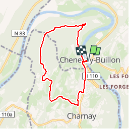
Tocht Stappen van 7,6 km beschikbaar op Bourgondië-Franche-Comté, Doubs. Deze tocht wordt voorgesteld door tracegps.
Beschrijving
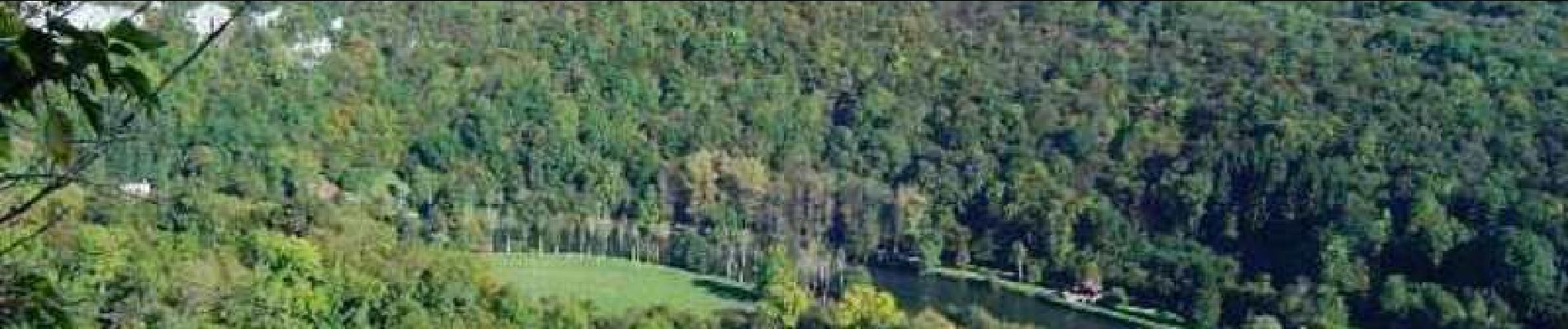
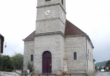
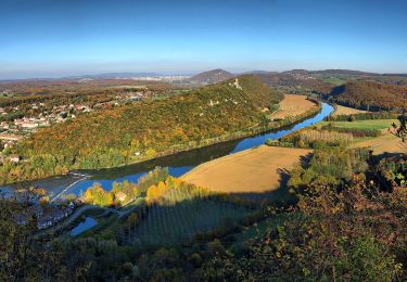
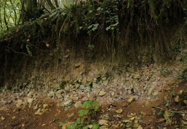
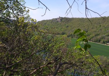
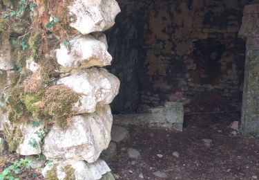
Prudence aux abords directs des ruines du château - chutes de pierres, trous, précipice ! Charmante petite randonnée au départ de l'accueillant village de Chenecey-Buillon où l'on y découvre les mystérieuses ruines du château de Charencey surplombant le Grand Méandre formé par la Loue. La balade se poursuit par un bois sombre contrastant avec la lumière des belles pâtures au-dessus de Charnay où trône un beau tilleul au bord du chemin. La suite avec d’autres informations et photos est ICI
Plaatsbepaling
Opmerkingen
Wandeltochten in de omgeving
![Tocht Te voet Busy - Sentier de la Pierre de Vorges - Photo](https://media.geolcdn.com/t/375/260/6f249824-322a-4d94-8931-19d5b1d90e88.jpeg&format=jpg&maxdim=2)
![Te voet Te voet](https://static1.geolcdn.com/sitytour/trail-icons/100.png)
Te voet
![](/images/other/stat-length.png)
![](https://static1.geolcdn.com/siteimages/upload/files/16400158638029165_repeat_loop_refresh_sync_direction_icon.png)
![Tocht Te voet Vorges-les-Pins - Sentier des Crêtes - Photo](https://media.geolcdn.com/t/375/260/11000138-aa02-48df-818f-23d3321a98ed.jpeg&format=jpg&maxdim=2)
![Te voet Te voet](https://static1.geolcdn.com/sitytour/trail-icons/100.png)
Te voet
![](/images/other/stat-length.png)
![](https://static1.geolcdn.com/siteimages/upload/files/16400158638029165_repeat_loop_refresh_sync_direction_icon.png)
![Tocht Te voet Boussières - Sentier du Ruisseau - Photo](https://media.geolcdn.com/t/375/260/4b9f6489-2cea-48c8-a931-7d2d0fad9445.jpeg&format=jpg&maxdim=2)
![Te voet Te voet](https://static1.geolcdn.com/sitytour/trail-icons/100.png)
Te voet
![](/images/other/stat-length.png)
![](https://static1.geolcdn.com/siteimages/upload/files/16400158638029165_repeat_loop_refresh_sync_direction_icon.png)
![Tocht Te voet Montferrand-le-Château - Sentier de Crête et Bois Rapin - Photo](https://media.geolcdn.com/t/375/260/c8b25516-529e-4f5c-85cb-5313429ddb47.jpeg&format=jpg&maxdim=2)
![Te voet Te voet](https://static1.geolcdn.com/sitytour/trail-icons/100.png)
Te voet
![](/images/other/stat-length.png)
![](https://static1.geolcdn.com/siteimages/upload/files/16400158638029165_repeat_loop_refresh_sync_direction_icon.png)
![Tocht Te voet Thoraise - Sentier de Notre Dame du Mont - Photo](https://media.geolcdn.com/t/375/260/e4c78328-7a72-4c70-b054-e885f49e43ee.jpeg&format=jpg&maxdim=2)
![Te voet Te voet](https://static1.geolcdn.com/sitytour/trail-icons/100.png)
Te voet
![](/images/other/stat-length.png)
![](https://static1.geolcdn.com/siteimages/upload/files/16400158638029165_repeat_loop_refresh_sync_direction_icon.png)
![Tocht Stappen Pugey - pugey vierge comice arguel - Photo](https://media.geolcdn.com/t/375/260/210ae8a7-1f70-4f24-86c2-2d030290ac2e.jpg&format=jpg&maxdim=2)
![Stappen Stappen](https://static1.geolcdn.com/sitytour/trail-icons/101.png)
Stappen
![](/images/other/stat-length.png)
![](https://static1.geolcdn.com/siteimages/upload/files/16400158638029165_repeat_loop_refresh_sync_direction_icon.png)
![Tocht Stappen Boussières - Boussières crête - Photo](https://media.geolcdn.com/t/375/260/59815f49-0266-454c-acab-aa8c73607952.jpg&format=jpg&maxdim=2)
![Stappen Stappen](https://static1.geolcdn.com/sitytour/trail-icons/101.png)
Stappen
![](/images/other/stat-length.png)
![](https://static1.geolcdn.com/siteimages/upload/files/16400158638029165_repeat_loop_refresh_sync_direction_icon.png)
![Tocht Stappen Busy - Busy Vierge du mont - Photo](https://media.geolcdn.com/t/375/260/a4594e72-5506-4551-90b2-490d3330d43d.jpg&format=jpg&maxdim=2)
![Stappen Stappen](https://static1.geolcdn.com/sitytour/trail-icons/101.png)
Stappen
![](/images/other/stat-length.png)
![](https://static1.geolcdn.com/siteimages/upload/files/16400158638029165_repeat_loop_refresh_sync_direction_icon.png)
![Tocht Stappen Charnay - charnay - Photo](https://media.geolcdn.com/t/375/260/3a0b88c5-1d96-4f44-a545-03b03b7ef47c.jpg&format=jpg&maxdim=2)
![Stappen Stappen](https://static1.geolcdn.com/sitytour/trail-icons/101.png)
Stappen
![](/images/other/stat-length.png)
![](https://static1.geolcdn.com/siteimages/upload/files/16400158638029165_repeat_loop_refresh_sync_direction_icon.png)