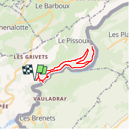
![](/images/other/stat-length.png)
![Tocht Stappen Villers-le-Lac - Gorges du Doubs depuis le Saut du Doubs - Photo](https://media.geolcdn.com/t/1900/400/ext.pjpeg?maxdim=2&url=https%3A%2F%2Fservices.sitytrail.com%2FGeolivesWS%2FDownloadMedia.ashx%3FTrailID%3D108777%26Media%3D1919_2.jpg)
Gorges du Doubs depuis le Saut du Doubs
tracegps
Gebruiker
![Lengte](/images/other/stat-length.png)
![Max. hoogte](https://static1.geolcdn.com/siteimages/upload/files/1508320355ic_sort_altitude_max_24dp.png)
![Positief hoogteverschil](https://static1.geolcdn.com/siteimages/upload/files/1508320355ic_sort_den_pos_24dp.png)
![Km-Effort](/images/other/stat-length.png)
![Min. hoogte](https://static1.geolcdn.com/siteimages/upload/files/1508320355ic_sort_altitude_min_24dp.png)
![Negatief hoogteverschil](https://static1.geolcdn.com/siteimages/upload/files/1508320355ic_sort_den_neg_24dp.png)
![Boucle](https://static1.geolcdn.com/siteimages/upload/files/16400158638029165_repeat_loop_refresh_sync_direction_icon.png)
![Stappen](https://static1.geolcdn.com/sitytour/trail-icons/101.png)
4h00
Moeilijkheid : Moeilijk
![Scan deze QR-code om de tocht te openen in de SityTrail-applicatie](https://capi.geolives.com/qq0zvz2zws4bq2lad0pu/sitytour/trails/108777/qr.png?size=200)
Gratisgps-wandelapplicatie
Over ons
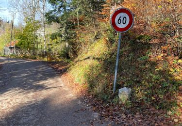
Tocht Stappen van 12,8 km beschikbaar op Bourgondië-Franche-Comté, Doubs, Villers-le-Lac. Deze tocht wordt voorgesteld door tracegps.
Beschrijving
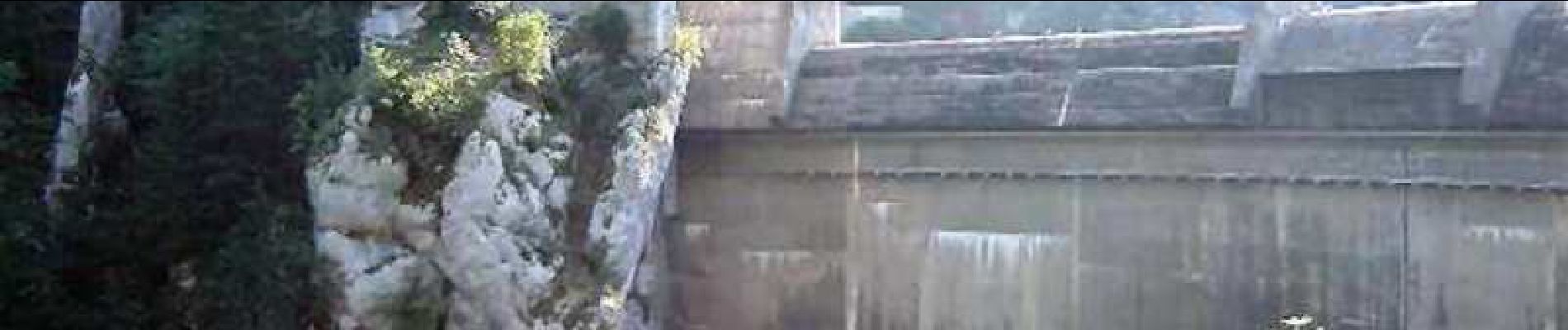
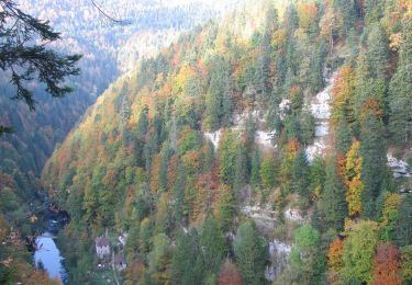
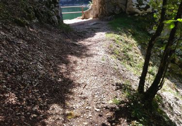
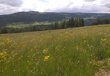
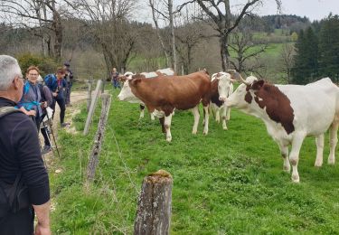
Depuis Villers-le-Lac, le Doubs s'enfonce dans une vallée profonde et sinueuse formant ainsi de très jolies gorges. C'est la première partie de ces gorges du Doubs que cette randonnée propose de découvrir entre le grandiose Saut du Doubs et le barrage du Châtelot. La suite avec d’autres informations et photos est ICI
Plaatsbepaling
Opmerkingen
Wandeltochten in de omgeving
![Tocht Stappen Villers-le-Lac - Le saut du Doubs et le Châtelard - Photo](https://media.geolcdn.com/t/375/260/ext.jpg?maxdim=2&url=https%3A%2F%2Fservices.sitytrail.com%2FGeolivesWS%2FDownloadMedia.ashx%3FTrailID%3D792633%26Media%3Dfix__20170717135052.jpg)
![Stappen Stappen](https://static1.geolcdn.com/sitytour/trail-icons/101.png)
Stappen
![](/images/other/stat-length.png)
![](https://static1.geolcdn.com/siteimages/upload/files/16400158638029165_repeat_loop_refresh_sync_direction_icon.png)
![Tocht Te voet Le Locle - Hôtel du Saut du Doubs - Gare des Brenets - Photo](https://media.geolcdn.com/t/375/260/4e2b223b-5d1f-4722-b3d5-d37a87436a7c.jpeg&format=jpg&maxdim=2)
![Te voet Te voet](https://static1.geolcdn.com/sitytour/trail-icons/100.png)
Te voet
![](/images/other/stat-length.png)
![](https://static1.geolcdn.com/siteimages/upload/files/16400158638029165_repeat_loop_refresh_sync_direction_icon.png)
![Tocht Te voet Le Locle - Les Frêtes - fixme - Photo](https://media.geolcdn.com/t/375/260/0dfa81c4-ea86-4670-a9e2-4edd9205728f.jpeg&format=jpg&maxdim=2)
![Te voet Te voet](https://static1.geolcdn.com/sitytour/trail-icons/100.png)
Te voet
![](/images/other/stat-length.png)
![](https://static1.geolcdn.com/siteimages/upload/files/16400158638029165_repeat_loop_refresh_sync_direction_icon.png)
![Tocht Te voet Les Planchettes - Barrage du Châtelot - Saut du Doubs - Photo](https://media.geolcdn.com/t/375/260/c02ae770-bade-4d71-b842-d1ab9da9220c.jpeg&format=jpg&maxdim=2)
![Te voet Te voet](https://static1.geolcdn.com/sitytour/trail-icons/100.png)
Te voet
![](/images/other/stat-length.png)
![](https://static1.geolcdn.com/siteimages/upload/files/16400158638029165_repeat_loop_refresh_sync_direction_icon.png)
![Tocht Stappen Villers-le-Lac - 25 saut du Doubs jura 08.08.24 - Photo](https://media.geolcdn.com/t/375/260/69ae39c7-0bce-4ef7-9703-c0fe844c8fa9.jpg&format=jpg&maxdim=2)
![Stappen Stappen](https://static1.geolcdn.com/sitytour/trail-icons/101.png)
Stappen
![](/images/other/stat-length.png)
![](https://static1.geolcdn.com/siteimages/upload/files/16400158638029165_repeat_loop_refresh_sync_direction_icon.png)
![Tocht Stappen Villers-le-Lac - barrage chatelot saut du doubs le pissoux - Photo](https://media.geolcdn.com/t/375/260/9ddc7c9d-2c55-4135-9d10-7ad8ed129ab8.jpg&format=jpg&maxdim=2)
![Stappen Stappen](https://static1.geolcdn.com/sitytour/trail-icons/101.png)
Stappen
![](/images/other/stat-length.png)
![](https://static1.geolcdn.com/siteimages/upload/files/16400158638029165_repeat_loop_refresh_sync_direction_icon.png)
![Tocht Stappen Villers-le-Lac - Le Pisoux - Photo](https://media.geolcdn.com/t/375/260/4a715c23-f970-4542-83cb-bb9163df6e0f.jpg&format=jpg&maxdim=2)
![Stappen Stappen](https://static1.geolcdn.com/sitytour/trail-icons/101.png)
Stappen
![](/images/other/stat-length.png)
![](https://static1.geolcdn.com/siteimages/upload/files/16400158638029165_repeat_loop_refresh_sync_direction_icon.png)
![Tocht Stappen Villers-le-Lac - Saut du Doubs - Photo](https://media.geolcdn.com/t/375/260/5bf04ea4-00d2-4096-ab82-e6f5e7455237.jpg&format=jpg&maxdim=2)
![Stappen Stappen](https://static1.geolcdn.com/sitytour/trail-icons/101.png)
Stappen
![](/images/other/stat-length.png)
![](https://static1.geolcdn.com/siteimages/upload/files/16400158638029165_repeat_loop_refresh_sync_direction_icon.png)
tete a calvin