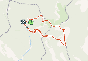
![](/images/other/stat-length.png)
![Tocht Stappen Venterol - Le cougoir depuis la Combe de sauve à Venterol - Photo](https://media.geolcdn.com/t/1900/400/ext.pjpeg?maxdim=2&url=https%3A%2F%2Fstatic1.geolcdn.com%2Fsiteimages%2Fupload%2Ffiles%2F1553511878bg_sport_marche.png)
Le cougoir depuis la Combe de sauve à Venterol
aitkhedache
Gebruiker
![Lengte](/images/other/stat-length.png)
![Max. hoogte](https://static1.geolcdn.com/siteimages/upload/files/1508320355ic_sort_altitude_max_24dp.png)
![Positief hoogteverschil](https://static1.geolcdn.com/siteimages/upload/files/1508320355ic_sort_den_pos_24dp.png)
![Km-Effort](/images/other/stat-length.png)
![Min. hoogte](https://static1.geolcdn.com/siteimages/upload/files/1508320355ic_sort_altitude_min_24dp.png)
![Negatief hoogteverschil](https://static1.geolcdn.com/siteimages/upload/files/1508320355ic_sort_den_neg_24dp.png)
![Boucle](https://static1.geolcdn.com/siteimages/upload/files/16400158638029165_repeat_loop_refresh_sync_direction_icon.png)
![Stappen](https://static1.geolcdn.com/sitytour/trail-icons/101.png)
4h25
Moeilijkheid : Medium
![Scan deze QR-code om de tocht te openen in de SityTrail-applicatie](https://capi.geolives.com/qq0zvz2zws4bq2lad0pu/sitytour/trails/1086693/qr.png?size=200)
Gratisgps-wandelapplicatie
Over ons
Tocht Stappen van 10,1 km beschikbaar op Auvergne-Rhône-Alpes, Drôme, Venterol. Deze tocht wordt voorgesteld door aitkhedache.
Beschrijving
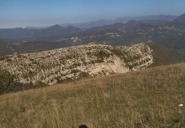
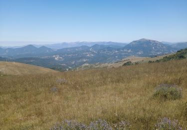
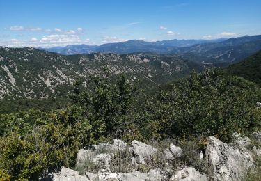
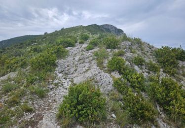
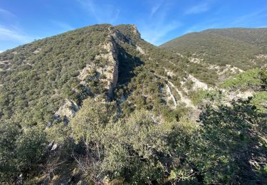
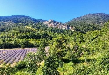
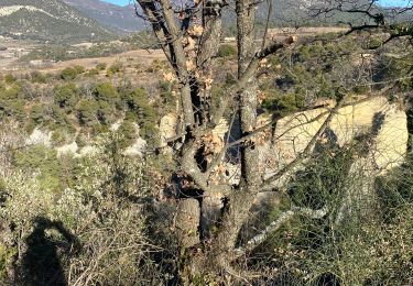
Le parking se trouve tout au bout de la combe de Sauve. Prendre le sentier parfaitement balisé en jaune. Le sommet du Cougoir offre une vue extraordinaire sur les alpes: barres des Aravis et du Dévoluy . La montée est assez rude sur le dernier km tout en n'offrant aucune difficulté technique.
Plaatsbepaling
Opmerkingen
Wandeltochten in de omgeving
![Tocht Stappen Rousset-les-Vignes - Rousset- La Lance - Photo](https://media.geolcdn.com/t/375/260/84d3931f-2eee-4f55-959d-db8a6d419ca0.jpg&format=jpg&maxdim=2)
![Stappen Stappen](https://static1.geolcdn.com/sitytour/trail-icons/101.png)
Stappen
![](/images/other/stat-length.png)
![](https://static1.geolcdn.com/siteimages/upload/files/16400158638029165_repeat_loop_refresh_sync_direction_icon.png)
![Tocht Stappen Rousset-les-Vignes - 26 Rousset les vignes - Photo](https://media.geolcdn.com/t/375/260/ef2bc63b-d52c-4891-aa41-763031d43809.jpg&format=jpg&maxdim=2)
![Stappen Stappen](https://static1.geolcdn.com/sitytour/trail-icons/101.png)
Stappen
![](/images/other/stat-length.png)
![](https://static1.geolcdn.com/siteimages/upload/files/16400158638029165_repeat_loop_refresh_sync_direction_icon.png)
![Tocht Stappen Teyssières - 26 cougoir zel - Photo](https://media.geolcdn.com/t/375/260/73f2a032-a019-4e88-aecb-d5d32d3ee0aa.jpg&format=jpg&maxdim=2)
![Stappen Stappen](https://static1.geolcdn.com/sitytour/trail-icons/101.png)
Stappen
![](/images/other/stat-length.png)
![](https://static1.geolcdn.com/siteimages/upload/files/16400158638029165_repeat_loop_refresh_sync_direction_icon.png)
![Tocht Stappen Venterol - le cougoir - Photo](https://media.geolcdn.com/t/375/260/37fd75d5-0091-4964-9bad-4ec775b5e571.jpg&format=jpg&maxdim=2)
![Stappen Stappen](https://static1.geolcdn.com/sitytour/trail-icons/101.png)
Stappen
![](/images/other/stat-length.png)
![](https://static1.geolcdn.com/siteimages/upload/files/16400158638029165_repeat_loop_refresh_sync_direction_icon.png)
![Tocht Stappen Aubres - aubres - Photo](https://media.geolcdn.com/t/375/260/7d05846c-fe40-45f3-8b74-7336a75fdef1.jpg&format=jpg&maxdim=2)
![Stappen Stappen](https://static1.geolcdn.com/sitytour/trail-icons/101.png)
Stappen
![](/images/other/stat-length.png)
![](https://static1.geolcdn.com/siteimages/upload/files/16400158638029165_repeat_loop_refresh_sync_direction_icon.png)
![Tocht Stappen Teyssières - Randonnée au départ de Teyssières (Le Cougoir, La Lance) - Photo](https://media.geolcdn.com/t/375/260/94a27539-2910-4367-af66-73c1555d2126.jpg&format=jpg&maxdim=2)
![Stappen Stappen](https://static1.geolcdn.com/sitytour/trail-icons/101.png)
Stappen
![](/images/other/stat-length.png)
![](https://static1.geolcdn.com/siteimages/upload/files/16400158638029165_repeat_loop_refresh_sync_direction_icon.png)
![Tocht Stappen Rousset-les-Vignes - Rousset les vignes sous La Chapelle - Photo](https://media.geolcdn.com/t/375/260/b76d0e6c-736e-44c5-b779-1ce4c6c7950a.jpg&format=jpg&maxdim=2)
![Stappen Stappen](https://static1.geolcdn.com/sitytour/trail-icons/101.png)
Stappen
![](/images/other/stat-length.png)
![](https://static1.geolcdn.com/siteimages/upload/files/16400158638029165_repeat_loop_refresh_sync_direction_icon.png)
![Tocht Stappen Teyssières - 2022-09-27_10h31m20_Teyssieres Cougoir 12km - Photo](https://media.geolcdn.com/t/375/260/c1b90102-3f17-42c6-9eaa-274a207a9df3.jpg&format=jpg&maxdim=2)
![Stappen Stappen](https://static1.geolcdn.com/sitytour/trail-icons/101.png)
Stappen
![](/images/other/stat-length.png)
![](https://static1.geolcdn.com/siteimages/upload/files/16400158638029165_repeat_loop_refresh_sync_direction_icon.png)
![Tocht Stappen Saint-Pantaléon-les-Vignes - Saint Pantaleon crevasses. - Photo](https://media.geolcdn.com/t/375/260/45ec6a80-1cce-4239-97f4-da896d149d69.jpg&format=jpg&maxdim=2)
![Stappen Stappen](https://static1.geolcdn.com/sitytour/trail-icons/101.png)
Stappen
![](/images/other/stat-length.png)
![](https://static1.geolcdn.com/siteimages/upload/files/16400158638029165_repeat_loop_refresh_sync_direction_icon.png)