![](/images/other/stat-length.png)
![Tocht Stappen Parfondeval - Par le fond du val - Photo](https://media.geolcdn.com/t/1900/400/ext.pjpeg?maxdim=2&url=https%3A%2F%2Fservices.sitytrail.com%2FGeolivesWS%2FDownloadMedia.ashx%3FTrailID%3D108375%26Media%3D1059_2.jpg)
Par le fond du val
tracegps
Gebruiker
![Lengte](/images/other/stat-length.png)
Lengte
13 km
![Max. hoogte](https://static1.geolcdn.com/siteimages/upload/files/1508320355ic_sort_altitude_max_24dp.png)
Max. hoogte
245 m
![Positief hoogteverschil](https://static1.geolcdn.com/siteimages/upload/files/1508320355ic_sort_den_pos_24dp.png)
Positief hoogteverschil
143 m
![Km-Effort](/images/other/stat-length.png)
Km-Effort
14,9 km
![Min. hoogte](https://static1.geolcdn.com/siteimages/upload/files/1508320355ic_sort_altitude_min_24dp.png)
Min. hoogte
173 m
![Negatief hoogteverschil](https://static1.geolcdn.com/siteimages/upload/files/1508320355ic_sort_den_neg_24dp.png)
Negatief hoogteverschil
143 m
![Boucle](https://static1.geolcdn.com/siteimages/upload/files/16400158638029165_repeat_loop_refresh_sync_direction_icon.png)
Boucle
Ja
Datum van aanmaak :
2014-12-10 00:00:00.0
Laatste wijziging :
2014-12-10 00:00:00.0
![Stappen](https://static1.geolcdn.com/sitytour/trail-icons/101.png)
3h30
Moeilijkheid : Zeer moeilijk
![Scan deze QR-code om de tocht te openen in de SityTrail-applicatie](https://capi.geolives.com/qq0zvz2zws4bq2lad0pu/sitytour/trails/108375/qr.png?size=200)
Gratisgps-wandelapplicatie
Over ons
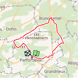
Tocht Stappen van 13 km beschikbaar op Hauts-de-France, Aisne, Parfondeval. Deze tocht wordt voorgesteld door tracegps.
Beschrijving
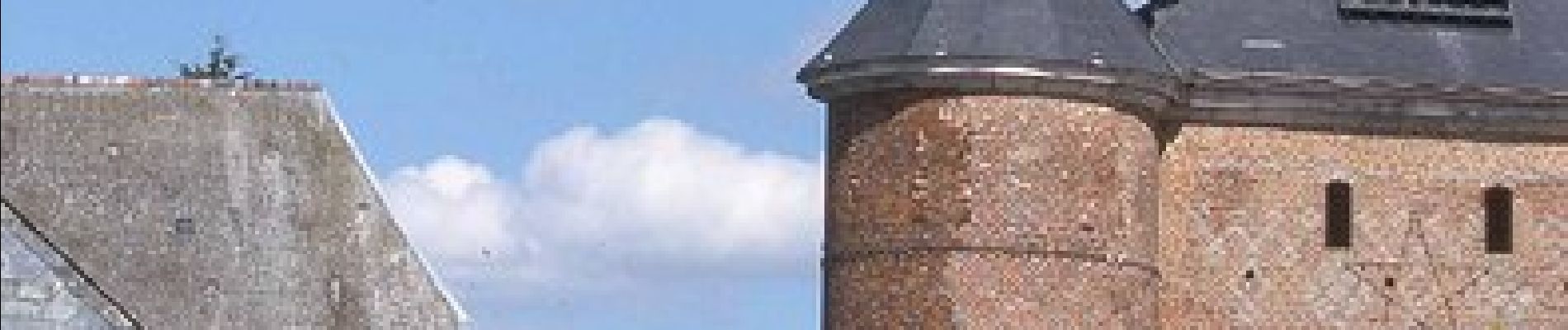
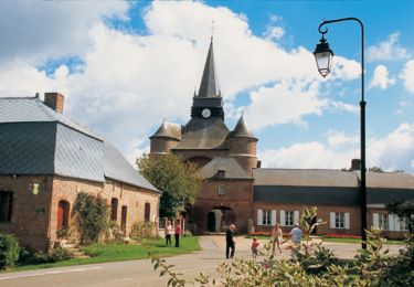
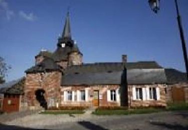
Classé parmi les "plus beaux villages de France", Parfondeval, avec son église fortifiée dominant la Brune et ses maisons de brique ou à colombages, est le point de départ de ce parcours entre vergers de pommiers et petits bois de feuillus. Toutes les infos sont ICI
Plaatsbepaling
Land:
France
Regio :
Hauts-de-France
Departement/Provincie :
Aisne
Gemeente :
Parfondeval
Locatie:
Unknown
Vertrek:(Dec)
Vertrek:(UTM)
583576 ; 5510314 (31U) N.
Opmerkingen
Wandeltochten in de omgeving
![Tocht Te voet Brunehamel - Par le fond du val - Photo](https://media.geolcdn.com/t/375/260/8e3a953d-955c-4c62-a89d-391f5e526a72.jpeg&format=jpg&maxdim=2)
![Te voet Te voet](https://static1.geolcdn.com/sitytour/trail-icons/100.png)
Par le fond du val
Te voet
Gemakkelijk
Brunehamel,
Hauts-de-France,
Aisne,
France
![](/images/other/stat-length.png)
12,5 km | 14,2 km-effort
3h 14min
![](https://static1.geolcdn.com/siteimages/upload/files/16400158638029165_repeat_loop_refresh_sync_direction_icon.png)
Ja
![Tocht Stappen Brunehamel - 2023_04_23 PARFONDEVAL - Photo](https://media.geolcdn.com/t/375/260/376aed58-e901-440d-acd2-8ccf990f5b65.jpg&format=jpg&maxdim=2)
![Stappen Stappen](https://static1.geolcdn.com/sitytour/trail-icons/101.png)
2023_04_23 PARFONDEVAL
Stappen
Moeilijk
Brunehamel,
Hauts-de-France,
Aisne,
France
![](/images/other/stat-length.png)
10,5 km | 12,4 km-effort
2h 49min
![](https://static1.geolcdn.com/siteimages/upload/files/16400158638029165_repeat_loop_refresh_sync_direction_icon.png)
Neen
![Tocht Stappen Parfondeval - Le chemin de la brique et du torchis - Photo](https://media.geolcdn.com/t/375/260/ext.jpg?maxdim=2&url=https%3A%2F%2Fservices.sitytrail.com%2FGeolivesWS%2FDownloadMedia.ashx%3FTrailID%3D108963%26Media%3D2852_1.jpg)
![Stappen Stappen](https://static1.geolcdn.com/sitytour/trail-icons/101.png)
Le chemin de la brique et du torchis
Stappen
Gemakkelijk
Parfondeval,
Hauts-de-France,
Aisne,
France
![](/images/other/stat-length.png)
1,4 km | 1,7 km-effort
45min
![](https://static1.geolcdn.com/siteimages/upload/files/16400158638029165_repeat_loop_refresh_sync_direction_icon.png)
Ja
![Tocht Stappen Résigny - Du chemin de fer au chemin vert - Photo](https://media.geolcdn.com/t/375/260/ext.jpg?maxdim=2&url=https%3A%2F%2Fstatic1.geolcdn.com%2Fsiteimages%2Fupload%2Ffiles%2F1553511878bg_sport_marche.png)
![Stappen Stappen](https://static1.geolcdn.com/sitytour/trail-icons/101.png)
Du chemin de fer au chemin vert
Stappen
Medium
Résigny,
Hauts-de-France,
Aisne,
France
![](/images/other/stat-length.png)
7,6 km | 9,2 km-effort
2h 30min
![](https://static1.geolcdn.com/siteimages/upload/files/16400158638029165_repeat_loop_refresh_sync_direction_icon.png)
Ja
![Tocht Stappen Parfondeval - Le chemin de la brique et du torchis - Photo](https://media.geolcdn.com/t/375/260/ext.jpg?maxdim=2&url=https%3A%2F%2Fservices.sitytrail.com%2FGeolivesWS%2FDownloadMedia.ashx%3FTrailID%3D202835%26Media%3D55446afe-e8cc-4c8a-9dd2-8ae97c09a375.jpg)
![Stappen Stappen](https://static1.geolcdn.com/sitytour/trail-icons/101.png)
Le chemin de la brique et du torchis
Stappen
Heel gemakkelijk
Parfondeval,
Hauts-de-France,
Aisne,
France
![](/images/other/stat-length.png)
1,4 km | 1,7 km-effort
Onbekend
![](https://static1.geolcdn.com/siteimages/upload/files/16400158638029165_repeat_loop_refresh_sync_direction_icon.png)
Ja