![](/images/other/stat-length.png)
![Tocht Stappen Charly-sur-Marne - Entre ciel et vignes - Photo](https://media.geolcdn.com/t/1900/400/ext.pjpeg?maxdim=2&url=https%3A%2F%2Fservices.sitytrail.com%2FGeolivesWS%2FDownloadMedia.ashx%3FTrailID%3D108344%26Media%3D1015_2.jpg)
Entre ciel et vignes
tracegps
Gebruiker
![Lengte](/images/other/stat-length.png)
![Max. hoogte](https://static1.geolcdn.com/siteimages/upload/files/1508320355ic_sort_altitude_max_24dp.png)
![Positief hoogteverschil](https://static1.geolcdn.com/siteimages/upload/files/1508320355ic_sort_den_pos_24dp.png)
![Km-Effort](/images/other/stat-length.png)
![Min. hoogte](https://static1.geolcdn.com/siteimages/upload/files/1508320355ic_sort_altitude_min_24dp.png)
![Negatief hoogteverschil](https://static1.geolcdn.com/siteimages/upload/files/1508320355ic_sort_den_neg_24dp.png)
![Boucle](https://static1.geolcdn.com/siteimages/upload/files/16400158638029165_repeat_loop_refresh_sync_direction_icon.png)
![Stappen](https://static1.geolcdn.com/sitytour/trail-icons/101.png)
4h00
Moeilijkheid : Zeer moeilijk
![Scan deze QR-code om de tocht te openen in de SityTrail-applicatie](https://capi.geolives.com/qq0zvz2zws4bq2lad0pu/sitytour/trails/108344/qr.png?size=200)
Gratisgps-wandelapplicatie
Over ons
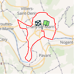
Tocht Stappen van 16,3 km beschikbaar op Hauts-de-France, Aisne, Charly-sur-Marne. Deze tocht wordt voorgesteld door tracegps.
Beschrijving
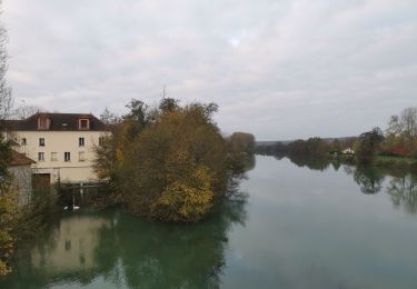
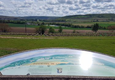
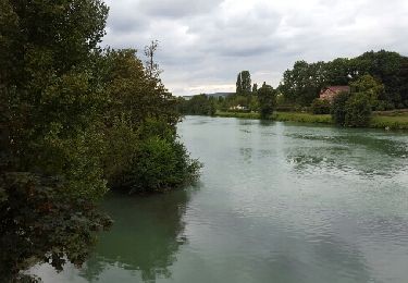
Depuis Charly, première commune viticole du département, on rejoint Saulchery, dominé par la statue de Napoléon 1er, puis la croix de Charly, où une table d'orientation permet d'identifier les nombreux villages de la vallée. Au retour, voir le barrage et l'écluse de Charly. Toutes les infos sont ICI
Plaatsbepaling
Opmerkingen
Wandeltochten in de omgeving
![Tocht sport Saâcy-sur-Marne - nanteuil-saacy-pavant-charly-marne-crouttes-boucle-27-km - Photo](https://media.geolcdn.com/t/375/260/ext.jpg?maxdim=2&url=https%3A%2F%2Fsecurestorage.geolives.com%2Fsitytour%2Ftrail-bg%2Fdefault.jpg)
sport
![](/images/other/stat-length.png)
![](https://static1.geolcdn.com/siteimages/upload/files/16400158638029165_repeat_loop_refresh_sync_direction_icon.png)
![Tocht Stappen Saâcy-sur-Marne - Le chemin de St Colomban en IDF ETAPE 2 Nanteuil -Jouarre - Photo](https://media.geolcdn.com/t/375/260/59b477ec-13ad-4f42-b3b4-8f7ce78d2d7b.jpg&format=jpg&maxdim=2)
![Stappen Stappen](https://static1.geolcdn.com/sitytour/trail-icons/101.png)
Stappen
![](/images/other/stat-length.png)
![](https://static1.geolcdn.com/siteimages/upload/files/16400158638029165_repeat_loop_refresh_sync_direction_icon.png)
![Tocht Stappen Saâcy-sur-Marne - Boucle Nanteuil Saacy - Charly sur Marne - Photo](https://media.geolcdn.com/t/375/260/14104ec2-2071-4530-9ea3-14b10ca4b8c0.jpg&format=jpg&maxdim=2)
![Stappen Stappen](https://static1.geolcdn.com/sitytour/trail-icons/101.png)
Stappen
![](/images/other/stat-length.png)
![](https://static1.geolcdn.com/siteimages/upload/files/16400158638029165_repeat_loop_refresh_sync_direction_icon.png)
![Tocht Stappen Villiers-Saint-Denis - Villiers St Denis du 11/02/2025 - Photo](https://media.geolcdn.com/t/375/260/e863674b-56b6-42d8-86c5-ab98636e8b4f.jpg&format=jpg&maxdim=2)
![Stappen Stappen](https://static1.geolcdn.com/sitytour/trail-icons/101.png)
Stappen
![](/images/other/stat-length.png)
![](https://static1.geolcdn.com/siteimages/upload/files/16400158638029165_repeat_loop_refresh_sync_direction_icon.png)
![Tocht Stappen Nogent-l'Artaud - RP51-07 Nogent-l'Artaud à la Ferté-sous-Jouarre - Photo](https://media.geolcdn.com/t/375/260/f9cca6fd-5edf-4350-9674-99a7d991e6ec.jpg&format=jpg&maxdim=2)
![Stappen Stappen](https://static1.geolcdn.com/sitytour/trail-icons/101.png)
Stappen
![](/images/other/stat-length.png)
![](https://static1.geolcdn.com/siteimages/upload/files/16400158638029165_repeat_loop_refresh_sync_direction_icon.png)
![Tocht Stappen Crouttes-sur-Marne - Crouttes-sur Marne du 20/05/2021 - Photo](https://media.geolcdn.com/t/375/260/7f54f421-be26-4aa7-983d-984ba58ca643.jpg&format=jpg&maxdim=2)
![Stappen Stappen](https://static1.geolcdn.com/sitytour/trail-icons/101.png)
Stappen
![](/images/other/stat-length.png)
![](https://static1.geolcdn.com/siteimages/upload/files/16400158638029165_repeat_loop_refresh_sync_direction_icon.png)
![Tocht Stappen Nogent-l'Artaud - Nogent Alzheimer - Photo](https://media.geolcdn.com/t/375/260/3c7b727a-e1eb-4312-8d80-2a70ff6ff562.jpg&format=jpg&maxdim=2)
![Stappen Stappen](https://static1.geolcdn.com/sitytour/trail-icons/101.png)
Stappen
![](/images/other/stat-length.png)
![](https://static1.geolcdn.com/siteimages/upload/files/16400158638029165_repeat_loop_refresh_sync_direction_icon.png)
![Tocht Stappen Saâcy-sur-Marne - NANTEUIL RANDO NOIX 13 KM - Photo](https://media.geolcdn.com/t/375/260/ext.jpg?maxdim=2&url=https%3A%2F%2Fstatic1.geolcdn.com%2Fsiteimages%2Fupload%2Ffiles%2F1553511878bg_sport_marche.png)
![Stappen Stappen](https://static1.geolcdn.com/sitytour/trail-icons/101.png)
Stappen
![](/images/other/stat-length.png)
![](https://static1.geolcdn.com/siteimages/upload/files/16400158638029165_repeat_loop_refresh_sync_direction_icon.png)
![Tocht Stappen Saâcy-sur-Marne - CRAB : la Dhuys pétillante - Photo](https://media.geolcdn.com/t/375/260/ext.jpg?maxdim=2&url=https%3A%2F%2Fservices.sitytrail.com%2FGeolivesWS%2FDownloadMedia.ashx%3FTrailID%3D629705%26Media%3Dfix__20160911143405.jpg)
![Stappen Stappen](https://static1.geolcdn.com/sitytour/trail-icons/101.png)
Stappen
![](/images/other/stat-length.png)
![](https://static1.geolcdn.com/siteimages/upload/files/16400158638029165_repeat_loop_refresh_sync_direction_icon.png)