![](/images/other/stat-length.png)
![Tocht Paard Brassac - Brassac - La Devèze - Photo](https://media.geolcdn.com/t/1900/400/ext.pjpeg?maxdim=2&url=https%3A%2F%2Fservices.sitytrail.com%2FGeolivesWS%2FDownloadMedia.ashx%3FTrailID%3D108254%26Media%3D896_1.jpg)
Brassac - La Devèze
tracegps
Gebruiker
![Lengte](/images/other/stat-length.png)
Lengte
12,7 km
![Max. hoogte](https://static1.geolcdn.com/siteimages/upload/files/1508320355ic_sort_altitude_max_24dp.png)
Max. hoogte
1710 m
![Positief hoogteverschil](https://static1.geolcdn.com/siteimages/upload/files/1508320355ic_sort_den_pos_24dp.png)
Positief hoogteverschil
1140 m
![Km-Effort](/images/other/stat-length.png)
Km-Effort
26 km
![Min. hoogte](https://static1.geolcdn.com/siteimages/upload/files/1508320355ic_sort_altitude_min_24dp.png)
Min. hoogte
598 m
![Negatief hoogteverschil](https://static1.geolcdn.com/siteimages/upload/files/1508320355ic_sort_den_neg_24dp.png)
Negatief hoogteverschil
579 m
![Boucle](https://static1.geolcdn.com/siteimages/upload/files/16400158638029165_repeat_loop_refresh_sync_direction_icon.png)
Boucle
Neen
Datum van aanmaak :
2014-12-10 00:00:00.0
Laatste wijziging :
2014-12-10 00:00:00.0
![Paard](https://static1.geolcdn.com/sitytour/trail-icons/300.png)
1h30
Moeilijkheid : Moeilijk
![Scan deze QR-code om de tocht te openen in de SityTrail-applicatie](https://capi.geolives.com/qq0zvz2zws4bq2lad0pu/sitytour/trails/108254/qr.png?size=200)
Gratisgps-wandelapplicatie
Over ons
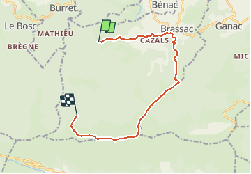
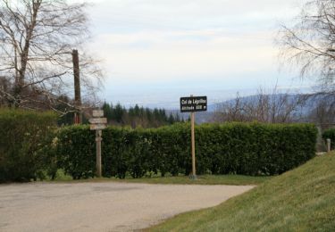
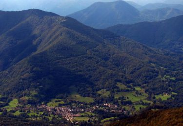
Tocht Paard van 12,7 km beschikbaar op Occitanië, Ariège, Brassac. Deze tocht wordt voorgesteld door tracegps.
Beschrijving
Balade proposée par le Bureau des Guides Équestres Transpyrénéens Toutes les randonnées équestres dans les Pyrénées Sans Frontières à Cheval
Plaatsbepaling
Land:
France
Regio :
Occitanië
Departement/Provincie :
Ariège
Gemeente :
Brassac
Locatie:
Unknown
Vertrek:(Dec)
Vertrek:(UTM)
377492 ; 4755371 (31T) N.
Opmerkingen
Wandeltochten in de omgeving
![Tocht Te voet Brassac - Le Picou depuis Brassac - Photo](https://media.geolcdn.com/t/375/260/22e65925-2aed-45df-a24b-d9dbd1aee596.jpeg&format=jpg&maxdim=2)
![Te voet Te voet](https://static1.geolcdn.com/sitytour/trail-icons/100.png)
Le Picou depuis Brassac
Te voet
Gemakkelijk
Brassac,
Occitanië,
Ariège,
France
![](/images/other/stat-length.png)
5 km | 14,7 km-effort
3h 20min
![](https://static1.geolcdn.com/siteimages/upload/files/16400158638029165_repeat_loop_refresh_sync_direction_icon.png)
Neen
![Tocht Stappen Boussenac - pic de la journalade - Photo](https://media.geolcdn.com/t/375/260/f09ef991-0863-41bd-a048-ac7c2441b9d4.jpg&format=jpg&maxdim=2)
![Stappen Stappen](https://static1.geolcdn.com/sitytour/trail-icons/101.png)
pic de la journalade
Stappen
Moeilijk
Boussenac,
Occitanië,
Ariège,
France
![](/images/other/stat-length.png)
16,6 km | 32 km-effort
6h 26min
![](https://static1.geolcdn.com/siteimages/upload/files/16400158638029165_repeat_loop_refresh_sync_direction_icon.png)
Ja
![Tocht Stappen Serres-sur-Arget - SERRES Sur ARGET - Photo](https://media.geolcdn.com/t/375/260/a178165b-4020-47c1-b1aa-022ac0a6feb3.jpg&format=jpg&maxdim=2)
![Stappen Stappen](https://static1.geolcdn.com/sitytour/trail-icons/101.png)
SERRES Sur ARGET
Stappen
Medium
Serres-sur-Arget,
Occitanië,
Ariège,
France
![](/images/other/stat-length.png)
10,6 km | 14,5 km-effort
2h 48min
![](https://static1.geolcdn.com/siteimages/upload/files/16400158638029165_repeat_loop_refresh_sync_direction_icon.png)
Ja
![Tocht Stappen Brassac - Cabane de la Devèze - Legrillou - Photo](https://media.geolcdn.com/t/375/260/ext.jpg?maxdim=2&url=https%3A%2F%2Fservices.sitytrail.com%2FGeolivesWS%2FDownloadMedia.ashx%3FTrailID%3D129653%26Media%3D13180_1.jpg)
![Stappen Stappen](https://static1.geolcdn.com/sitytour/trail-icons/101.png)
Cabane de la Devèze - Legrillou
Stappen
Gemakkelijk
Brassac,
Occitanië,
Ariège,
France
![](/images/other/stat-length.png)
9,7 km | 17,4 km-effort
1h 30min
![](https://static1.geolcdn.com/siteimages/upload/files/16400158638029165_repeat_loop_refresh_sync_direction_icon.png)
Ja
![Tocht Paard Saint-Pierre-de-Rivière - St Pierre de Rivière - St Martin de Caralp - Photo](https://media.geolcdn.com/t/375/260/ext.jpg?maxdim=2&url=https%3A%2F%2Fservices.sitytrail.com%2FGeolivesWS%2FDownloadMedia.ashx%3FTrailID%3D108265%26Media%3D907_1.jpg)
![Paard Paard](https://static1.geolcdn.com/sitytour/trail-icons/300.png)
St Pierre de Rivière - St Martin de Caralp
Paard
Medium
Saint-Pierre-de-Rivière,
Occitanië,
Ariège,
France
![](/images/other/stat-length.png)
8,9 km | 14 km-effort
1h 0min
![](https://static1.geolcdn.com/siteimages/upload/files/16400158638029165_repeat_loop_refresh_sync_direction_icon.png)
Neen
![Tocht Paard Brassac - Ganac - Col du Calmil - Photo](https://media.geolcdn.com/t/375/260/ext.jpg?maxdim=2&url=https%3A%2F%2Fservices.sitytrail.com%2FGeolivesWS%2FDownloadMedia.ashx%3FTrailID%3D108259%26Media%3D901_1.jpg)
![Paard Paard](https://static1.geolcdn.com/sitytour/trail-icons/300.png)
Ganac - Col du Calmil
Paard
Medium
Brassac,
Occitanië,
Ariège,
France
![](/images/other/stat-length.png)
4,1 km | 6 km-effort
30min
![](https://static1.geolcdn.com/siteimages/upload/files/16400158638029165_repeat_loop_refresh_sync_direction_icon.png)
Neen
![Tocht Paard Serres-sur-Arget - Serres-sur-Arget - La Devèze - Photo](https://media.geolcdn.com/t/375/260/ext.jpg?maxdim=2&url=https%3A%2F%2Fservices.sitytrail.com%2FGeolivesWS%2FDownloadMedia.ashx%3FTrailID%3D108255%26Media%3D897_1.jpg)
![Paard Paard](https://static1.geolcdn.com/sitytour/trail-icons/300.png)
Serres-sur-Arget - La Devèze
Paard
Moeilijk
Serres-sur-Arget,
Occitanië,
Ariège,
France
![](/images/other/stat-length.png)
11,8 km | 22 km-effort
1h 30min
![](https://static1.geolcdn.com/siteimages/upload/files/16400158638029165_repeat_loop_refresh_sync_direction_icon.png)
Neen
![Tocht Paard Boussenac - Boucle du Pic des 3 Seigneurs - Col de Port - Massat - Photo](https://media.geolcdn.com/t/375/260/ext.jpg?maxdim=2&url=https%3A%2F%2Fservices.sitytrail.com%2FGeolivesWS%2FDownloadMedia.ashx%3FTrailID%3D108202%26Media%3D839_1.jpg)
![Paard Paard](https://static1.geolcdn.com/sitytour/trail-icons/300.png)
Boucle du Pic des 3 Seigneurs - Col de Port - Massat
Paard
Moeilijk
Boussenac,
Occitanië,
Ariège,
France
![](/images/other/stat-length.png)
12,6 km | 17,1 km-effort
1h 30min
![](https://static1.geolcdn.com/siteimages/upload/files/16400158638029165_repeat_loop_refresh_sync_direction_icon.png)
Neen
![Tocht Sneeuwschoenen Boussenac - Pic d'Estibat - Photo](https://media.geolcdn.com/t/375/260/ext.jpg?maxdim=2&url=https%3A%2F%2Fservices.sitytrail.com%2FGeolivesWS%2FDownloadMedia.ashx%3FTrailID%3D104716%26Media%3D8135_1.jpg)
![Sneeuwschoenen Sneeuwschoenen](https://static1.geolcdn.com/sitytour/trail-icons/504.png)
Pic d'Estibat
Sneeuwschoenen
Medium
Boussenac,
Occitanië,
Ariège,
France
![](/images/other/stat-length.png)
5,2 km | 11 km-effort
3h 0min
![](https://static1.geolcdn.com/siteimages/upload/files/16400158638029165_repeat_loop_refresh_sync_direction_icon.png)
Ja