


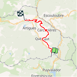

13,1 km | 26 km-effort

Gebruiker


Gratisgps-wandelapplicatie
 SityTrail
IGN / Geografische instituten
SityTrail World
De wereld gaat voor u open
Tocht Paard van 16,3 km beschikbaar op Occitanië, Pyrénées-Orientales, Puyvalador. Deze tocht wordt voorgesteld door tracegps.
Première étape du circuit « Sur la trace de Vauban ». Départ Col des Haros D’autres infos ICI. Balade proposée par le Bureau des Guides Équestres Transpyrénéens


Sneeuwschoenen


sport
Stappen

Stappen
Stappen
Stappen
Stappen
Stappen

Sneeuwschoenen