![](/images/other/stat-length.png)
![Tocht Paard Allières - Boucle dans le Massif de l'Arize - Allières - Clermont - Photo](https://media.geolcdn.com/t/1900/400/ext.pjpeg?maxdim=2&url=https%3A%2F%2Fservices.sitytrail.com%2FGeolivesWS%2FDownloadMedia.ashx%3FTrailID%3D108215%26Media%3D853_1.jpg)
Boucle dans le Massif de l'Arize - Allières - Clermont
tracegps
Gebruiker
![Lengte](/images/other/stat-length.png)
Lengte
8,1 km
![Max. hoogte](https://static1.geolcdn.com/siteimages/upload/files/1508320355ic_sort_altitude_max_24dp.png)
Max. hoogte
538 m
![Positief hoogteverschil](https://static1.geolcdn.com/siteimages/upload/files/1508320355ic_sort_den_pos_24dp.png)
Positief hoogteverschil
284 m
![Km-Effort](/images/other/stat-length.png)
Km-Effort
12 km
![Min. hoogte](https://static1.geolcdn.com/siteimages/upload/files/1508320355ic_sort_altitude_min_24dp.png)
Min. hoogte
340 m
![Negatief hoogteverschil](https://static1.geolcdn.com/siteimages/upload/files/1508320355ic_sort_den_neg_24dp.png)
Negatief hoogteverschil
319 m
![Boucle](https://static1.geolcdn.com/siteimages/upload/files/16400158638029165_repeat_loop_refresh_sync_direction_icon.png)
Boucle
Neen
Datum van aanmaak :
2014-12-10 00:00:00.0
Laatste wijziging :
2014-12-10 00:00:00.0
![Paard](https://static1.geolcdn.com/sitytour/trail-icons/300.png)
1h00
Moeilijkheid : Medium
![Scan deze QR-code om de tocht te openen in de SityTrail-applicatie](https://capi.geolives.com/qq0zvz2zws4bq2lad0pu/sitytour/trails/108215/qr.png?size=200)
Gratisgps-wandelapplicatie
Over ons
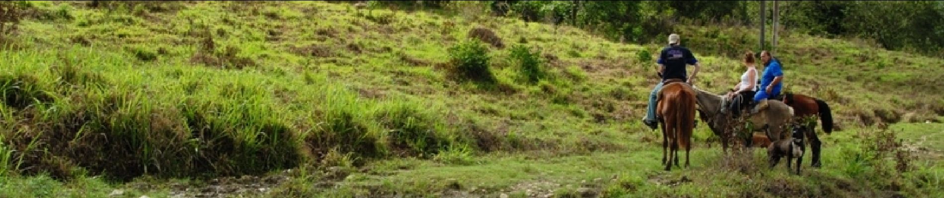
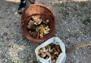
Tocht Paard van 8,1 km beschikbaar op Occitanië, Ariège, Allières. Deze tocht wordt voorgesteld door tracegps.
Beschrijving
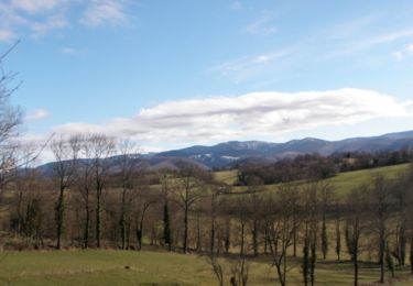
Première étape de la Boucle dans le Massif de l’Arize. D’autres infos ICI. Balade proposée par le Bureau des Guides Équestres Transpyrénéens
Plaatsbepaling
Land:
France
Regio :
Occitanië
Departement/Provincie :
Ariège
Gemeente :
Allières
Locatie:
Unknown
Vertrek:(Dec)
Vertrek:(UTM)
366855 ; 4766101 (31T) N.
Opmerkingen
Wandeltochten in de omgeving
![Tocht Elektrische fiets Castelnau-Durban - Castelnau Durban à Niaux - Photo](https://media.geolcdn.com/t/375/260/3634c15e-87a5-45e8-ad04-4341a035c5d7.jpg&format=jpg&maxdim=2)
![Elektrische fiets Elektrische fiets](https://static1.geolcdn.com/sitytour/trail-icons/205.png)
Castelnau Durban à Niaux
Elektrische fiets
Medium
Castelnau-Durban,
Occitanië,
Ariège,
France
![](/images/other/stat-length.png)
52 km | 63 km-effort
3h 8min
![](https://static1.geolcdn.com/siteimages/upload/files/16400158638029165_repeat_loop_refresh_sync_direction_icon.png)
Neen
![Tocht Stappen Le Mas-d'Azil - Mas d'Azil lac de Filliet - Photo](https://media.geolcdn.com/t/375/260/ext.jpg?maxdim=2&url=https%3A%2F%2Fservices.sitytrail.com%2FGeolivesWS%2FDownloadMedia.ashx%3FTrailID%3D773599%26Media%3Dfix__20170615174626.jpg)
![Stappen Stappen](https://static1.geolcdn.com/sitytour/trail-icons/101.png)
Mas d'Azil lac de Filliet
Stappen
Heel gemakkelijk
Le Mas-d'Azil,
Occitanië,
Ariège,
France
![](/images/other/stat-length.png)
13,3 km | 16,2 km-effort
3h 23min
![](https://static1.geolcdn.com/siteimages/upload/files/16400158638029165_repeat_loop_refresh_sync_direction_icon.png)
Ja
![Tocht Stappen Le Mas-d'Azil - Pyrénées-140906 - DolmensMasDazil - Photo](https://media.geolcdn.com/t/375/260/ext.jpg?maxdim=2&url=https%3A%2F%2Fservices.sitytrail.com%2FGeolivesWS%2FDownloadMedia.ashx%3FTrailID%3D343291%26Media%3Dfix__20140906120957.jpg)
![Stappen Stappen](https://static1.geolcdn.com/sitytour/trail-icons/101.png)
Pyrénées-140906 - DolmensMasDazil
Stappen
Medium
Le Mas-d'Azil,
Occitanië,
Ariège,
France
![](/images/other/stat-length.png)
13,1 km | 18,3 km-effort
5h 15min
![](https://static1.geolcdn.com/siteimages/upload/files/16400158638029165_repeat_loop_refresh_sync_direction_icon.png)
Ja
![Tocht Mountainbike Le Mas-d'Azil - Grande Traversée VTT FFC Arièges Pyrénées - Etape 10 - Le Mas d'Azil - Lescure - Photo](https://media.geolcdn.com/t/375/260/ext.jpg?maxdim=2&url=https%3A%2F%2Fservices.sitytrail.com%2FGeolivesWS%2FDownloadMedia.ashx%3FTrailID%3D104281%26Media%3D7487_3.jpg)
![Mountainbike Mountainbike](https://static1.geolcdn.com/sitytour/trail-icons/202.png)
Grande Traversée VTT FFC Arièges Pyrénées - Etape 10 - Le Mas d'Azil - Lescure
Mountainbike
Moeilijk
Le Mas-d'Azil,
Occitanië,
Ariège,
France
![](/images/other/stat-length.png)
16,5 km | 22 km-effort
1h 45min
![](https://static1.geolcdn.com/siteimages/upload/files/16400158638029165_repeat_loop_refresh_sync_direction_icon.png)
Neen
![Tocht Stappen Gabre - Champignons 26/08 - Photo](https://media.geolcdn.com/t/375/260/23a784d4-5102-4663-a790-a9e8218c868f.jpg&format=jpg&maxdim=2)
![Stappen Stappen](https://static1.geolcdn.com/sitytour/trail-icons/101.png)
Champignons 26/08
Stappen
Medium
Gabre,
Occitanië,
Ariège,
France
![](/images/other/stat-length.png)
4,8 km | 6,9 km-effort
2h 52min
![](https://static1.geolcdn.com/siteimages/upload/files/16400158638029165_repeat_loop_refresh_sync_direction_icon.png)
Ja
![Tocht Mountainbike Le Mas-d'Azil - Le Mas-d'Azil - Photo](https://media.geolcdn.com/t/375/260/ext.jpg?maxdim=2&url=https%3A%2F%2Fservices.sitytrail.com%2FGeolivesWS%2FDownloadMedia.ashx%3FTrailID%3D366249%26Media%3D20141129154530.jpg)
![Mountainbike Mountainbike](https://static1.geolcdn.com/sitytour/trail-icons/202.png)
Le Mas-d'Azil
Mountainbike
Moeilijk
Le Mas-d'Azil,
Occitanië,
Ariège,
France
![](/images/other/stat-length.png)
48 km | 63 km-effort
6h 2min
![](https://static1.geolcdn.com/siteimages/upload/files/16400158638029165_repeat_loop_refresh_sync_direction_icon.png)
Ja
![Tocht Mountainbike La Bastide-de-Sérou - segalas la bouiche et retour - Photo](https://media.geolcdn.com/t/375/260/ext.jpg?maxdim=2&url=https%3A%2F%2Fservices.sitytrail.com%2FGeolivesWS%2FDownloadMedia.ashx%3FTrailID%3D218527%26Media%3Dfix__20130902121734.jpg)
![Mountainbike Mountainbike](https://static1.geolcdn.com/sitytour/trail-icons/202.png)
segalas la bouiche et retour
Mountainbike
Gemakkelijk
La Bastide-de-Sérou,
Occitanië,
Ariège,
France
![](/images/other/stat-length.png)
36 km | 42 km-effort
2h 47min
![](https://static1.geolcdn.com/siteimages/upload/files/16400158638029165_repeat_loop_refresh_sync_direction_icon.png)
Neen
![Tocht Paard Le Mas-d'Azil - Le Mas d'Azil - Carla-Bayle - Photo](https://media.geolcdn.com/t/375/260/ext.jpg?maxdim=2&url=https%3A%2F%2Fservices.sitytrail.com%2FGeolivesWS%2FDownloadMedia.ashx%3FTrailID%3D108263%26Media%3D905_1.jpg)
![Paard Paard](https://static1.geolcdn.com/sitytour/trail-icons/300.png)
Le Mas d'Azil - Carla-Bayle
Paard
Moeilijk
Le Mas-d'Azil,
Occitanië,
Ariège,
France
![](/images/other/stat-length.png)
13,1 km | 18,4 km-effort
1h 30min
![](https://static1.geolcdn.com/siteimages/upload/files/16400158638029165_repeat_loop_refresh_sync_direction_icon.png)
Neen
![Tocht Paard Allières - Allières - Les Cabesses - Photo](https://media.geolcdn.com/t/375/260/ext.jpg?maxdim=2&url=https%3A%2F%2Fservices.sitytrail.com%2FGeolivesWS%2FDownloadMedia.ashx%3FTrailID%3D108250%26Media%3D892_1.jpg)
![Paard Paard](https://static1.geolcdn.com/sitytour/trail-icons/300.png)
Allières - Les Cabesses
Paard
Moeilijk
Allières,
Occitanië,
Ariège,
France
![](/images/other/stat-length.png)
28 km | 43 km-effort
2h 30min
![](https://static1.geolcdn.com/siteimages/upload/files/16400158638029165_repeat_loop_refresh_sync_direction_icon.png)
Neen