Tocht Stappen Malaucène - PF-Malaucène - Le Barroux au départ de Malaucène - V - Photo

PF-Malaucène - Le Barroux au départ de Malaucène - V

 MicDul
MicDul

Gebruiker

© OpenStreetMap contributors
Lengte
Lengte
18,6 km
Max. hoogte
Max. hoogte
474 m
Positief hoogteverschil
518 m
Km-Effort
Km-Effort  
25 km
Min. hoogte
Min. hoogte
276 m
Negatief hoogteverschil
518 m
Boucle
Boucle
Ja
Datum van aanmaak :
2018-11-30 09:55:16.35
Laatste wijziging :
2020-03-30 18:36:12.636

(0 Bericht)

Stappen
Stappen
5h24
Moeilijkheid : Medium

Scan deze QR-code om de tocht te openen in de SityTrail-applicatie

Gratisgps-wandelapplicatie

Logo SityTrail SityTrail

IGN / Geografische instituten

SityTrail uit de App Store downloaden SityTrail uit Google Play downloaden

Logo SityTrail SityTrail World

De wereld gaat voor u open

SityTrail uit de App Store downloaden SityTrail uit Google Play downloaden SityTrail op Huawei AppGallery downloaden

Over ons

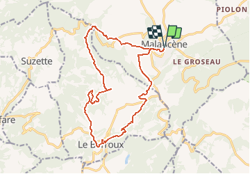
Tocht Stappen van 18,6 km beschikbaar op Provence-Alpes-Côte d'Azur, Vaucluse, Malaucène. Deze tocht wordt voorgesteld door MicDul.

Beschrijving

Se garer sur le parking de l’Église Saint-Michel à Malaucène.
(D/A) Du parking de l’Église Saint-Michel prendre l'Avenue de la Libération
vers le Sud, aller tout droit au giratoire et faire encore 100m sur l'Avenue de la Libération.

Hoogteprofiel

Foto's

POI's

POI Malaucène - Ruelle à droite - Photo
MicDul
MALAUCÈNE 
POI Malaucène - Sentier à droite - Photo
MicDul
MALAUCÈNE 
POI Malaucène - Chemin à droite - Photo
MicDul
MALAUCÈNE 
POI Malaucène - Col de la Chaîne - Photo
MicDul
MALAUCÈNE 
POI Le Barroux - GRP à droite - Photo
MicDul
LE BARROUX 
POI Le Barroux - Aller-retour aqueduc - Photo
MicDul
POI Le Barroux - Chemin à gauche - Photo
MicDul
LE BARROUX 
POI Le Barroux - Route à droite - Photo
MicDul
LE BARROUX 
POI Le Barroux - Rue en face - Photo
MicDul
LE BARROUX 
POI Le Barroux - Deux fois à droite - Photo
MicDul
POI Le Barroux - Route à gauche - Photo
MicDul
LE BARROUX 
POI Le Barroux - Route à droite - Photo
MicDul
LE BARROUX 
POI Malaucène - Route à droite - Photo
MicDul
MALAUCÈNE 

Plaatsbepaling

Land:
France
Regio :
Provence-Alpes-Côte d'Azur
Departement/Provincie :
Vaucluse
Gemeente :
Malaucène
Locatie:
Unknown
Vertrek:(Dec)
Vertrek:(UTM)
670466 ; 4893184 (31T) N.

Wandeltochten in de omgeving

Tocht Stappen Entrechaux - Entrechaux en Vaucluse - Photo
Stappen
tracegps

Stappen

Medium
(1)
Entrechaux, Provence-Alpes-Côte d'Azur, Vaucluse, France
9,5 km | 13,7 km-effort
2h 40min
Ja
Tocht Stappen Saint-Hippolyte-le-Graveyron - Le graveron petit circuit  - Photo
Stappen
Vero7684

Stappen

Gemakkelijk
(1)
Saint-Hippolyte-le-Graveyron, Provence-Alpes-Côte d'Azur, Vaucluse, France
5,7 km | 8,8 km-effort
2h 5min
Ja
Tocht Stappen Le Barroux - Les Crêtes du Graveyron par l'écluse de la Falque - Photo
Stappen
GUIDE
supercolas

Stappen

Moeilijk
Le Barroux, Provence-Alpes-Côte d'Azur, Vaucluse, France
9 km | 13,4 km-effort
2h 57min
Ja
Tocht Stappen Caromb - Les 3 Termes 449 le Groseau - Photo
Stappen
GUIDE
supercolas

Stappen

Medium
Caromb, Provence-Alpes-Côte d'Azur, Vaucluse, France
11,1 km | 16,9 km-effort
2h 56min
Ja
Tocht Stappen La Roque-Alric - Les 4 sommets de la Roque Alric - Photo
Stappen
GUIDE
supercolas

Stappen

Medium
La Roque-Alric, Provence-Alpes-Côte d'Azur, Vaucluse, France
10,9 km | 18 km-effort
3h 32min
Ja
Tocht Stappen La Roque-Alric - Rochers des Évêques  - Photo
Stappen
GUIDE
supercolas

Stappen

Medium
La Roque-Alric, Provence-Alpes-Côte d'Azur, Vaucluse, France
6,7 km | 11 km-effort
2h 26min
Ja
Tocht Stappen Le Barroux - Lac du Barroux - Photo
Stappen
alainbarrot

Stappen

Heel gemakkelijk
(2)
Le Barroux, Provence-Alpes-Côte d'Azur, Vaucluse, France
5,8 km | 8 km-effort
1h 42min
Ja
Tocht Lopen Le Barroux - Sortie Barroux - Photo
Lopen
ssi6159

Lopen

Heel gemakkelijk
(1)
Le Barroux, Provence-Alpes-Côte d'Azur, Vaucluse, France
12,9 km | 20 km-effort
1h 47min
Ja
Tocht Stappen Malaucène - Campagne de Malaucène - Photo
Stappen
tracegps

Stappen

Gemakkelijk
(2)
Malaucène, Provence-Alpes-Côte d'Azur, Vaucluse, France
6,6 km | 8,1 km-effort
1h 30min
Ja


Sluiten
Mijn abonnementen