![](/images/other/stat-length.png)
![Tocht Stappen Clara-Villerach - Au départ de Villerach - Photo](https://media.geolcdn.com/t/1900/400/ext.pjpeg?maxdim=2&url=https%3A%2F%2Fservices.sitytrail.com%2FGeolivesWS%2FDownloadMedia.ashx%3FTrailID%3D1078585%26Media%3D20181129134012.jpg)
Au départ de Villerach
ThonyM
Gebruiker
![Lengte](/images/other/stat-length.png)
Lengte
14 km
![Max. hoogte](https://static1.geolcdn.com/siteimages/upload/files/1508320355ic_sort_altitude_max_24dp.png)
Max. hoogte
1075 m
![Positief hoogteverschil](https://static1.geolcdn.com/siteimages/upload/files/1508320355ic_sort_den_pos_24dp.png)
Positief hoogteverschil
709 m
![Km-Effort](/images/other/stat-length.png)
Km-Effort
23 km
![Min. hoogte](https://static1.geolcdn.com/siteimages/upload/files/1508320355ic_sort_altitude_min_24dp.png)
Min. hoogte
454 m
![Negatief hoogteverschil](https://static1.geolcdn.com/siteimages/upload/files/1508320355ic_sort_den_neg_24dp.png)
Negatief hoogteverschil
712 m
![Boucle](https://static1.geolcdn.com/siteimages/upload/files/16400158638029165_repeat_loop_refresh_sync_direction_icon.png)
Boucle
Ja
Datum van aanmaak :
2019-01-15 19:23:05.252
Laatste wijziging :
2019-01-15 19:23:05.252
![Stappen](https://static1.geolcdn.com/sitytour/trail-icons/101.png)
4h31
Moeilijkheid : Medium
![Scan deze QR-code om de tocht te openen in de SityTrail-applicatie](https://capi.geolives.com/qq0zvz2zws4bq2lad0pu/sitytour/trails/1078585/qr.png?size=200)
Gratisgps-wandelapplicatie
Over ons
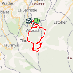
Tocht Stappen van 14 km beschikbaar op Occitanië, Pyrénées-Orientales, Clara-Villerach. Deze tocht wordt voorgesteld door ThonyM.
Beschrijving
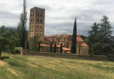
Parcours sans difficulté, très agréable, particulièrement aux couleurs de l'automne. Vue sur La Chapelle saint Esteve
Plaatsbepaling
Land:
France
Regio :
Occitanië
Departement/Provincie :
Pyrénées-Orientales
Gemeente :
Clara-Villerach
Locatie:
Unknown
Vertrek:(Dec)
Vertrek:(UTM)
455193 ; 4716189 (31T) N.
Opmerkingen
Wandeltochten in de omgeving
![Tocht Stappen Ria-Sirach - Sirach-Taurinya-Saint Michel de Cuxa - Photo](https://media.geolcdn.com/t/375/260/ext.jpg?maxdim=2&url=https%3A%2F%2Fservices.sitytrail.com%2FGeolivesWS%2FDownloadMedia.ashx%3FTrailID%3D631724%26Media%3D20160916113736.jpg)
![Stappen Stappen](https://static1.geolcdn.com/sitytour/trail-icons/101.png)
Sirach-Taurinya-Saint Michel de Cuxa
Stappen
Gemakkelijk
(2)
Ria-Sirach,
Occitanië,
Pyrénées-Orientales,
France
![](/images/other/stat-length.png)
13,5 km | 17,2 km-effort
2h 31min
![](https://static1.geolcdn.com/siteimages/upload/files/16400158638029165_repeat_loop_refresh_sync_direction_icon.png)
Ja
![Tocht Motor Codalet - Prades - Villefranche de Conflent - Evol - Photo](https://media.geolcdn.com/t/375/260/ext.jpg?maxdim=2&url=https%3A%2F%2Fservices.sitytrail.com%2FGeolivesWS%2FDownloadMedia.ashx%3FTrailID%3D554984%26Media%3D20160417170544.jpg)
![Motor Motor](https://static1.geolcdn.com/sitytour/trail-icons/400.png)
Prades - Villefranche de Conflent - Evol
Motor
Gemakkelijk
(1)
Codalet,
Occitanië,
Pyrénées-Orientales,
France
![](/images/other/stat-length.png)
36 km | 48 km-effort
3h 47min
![](https://static1.geolcdn.com/siteimages/upload/files/16400158638029165_repeat_loop_refresh_sync_direction_icon.png)
Neen
![Tocht Mountainbike Ria-Sirach - cami del pi - Photo](https://media.geolcdn.com/t/375/260/ext.jpg?maxdim=2&url=https%3A%2F%2Fstatic1.geolcdn.com%2Fsiteimages%2Fupload%2Ffiles%2F1524743154velo.jpg)
![Mountainbike Mountainbike](https://static1.geolcdn.com/sitytour/trail-icons/202.png)
cami del pi
Mountainbike
Heel gemakkelijk
(1)
Ria-Sirach,
Occitanië,
Pyrénées-Orientales,
France
![](/images/other/stat-length.png)
11,2 km | 18,4 km-effort
1h 52min
![](https://static1.geolcdn.com/siteimages/upload/files/16400158638029165_repeat_loop_refresh_sync_direction_icon.png)
Ja
![Tocht Stappen Taurinya - le Canigou depuis le col de Millères - Photo](https://media.geolcdn.com/t/375/260/ext.jpg?maxdim=2&url=https%3A%2F%2Fstatic1.geolcdn.com%2Fsiteimages%2Fupload%2Ffiles%2F1553511878bg_sport_marche.png)
![Stappen Stappen](https://static1.geolcdn.com/sitytour/trail-icons/101.png)
le Canigou depuis le col de Millères
Stappen
Moeilijk
(1)
Taurinya,
Occitanië,
Pyrénées-Orientales,
France
![](/images/other/stat-length.png)
22 km | 48 km-effort
8h 30min
![](https://static1.geolcdn.com/siteimages/upload/files/16400158638029165_repeat_loop_refresh_sync_direction_icon.png)
Ja
![Tocht Stappen Taurinya - b - Photo](https://media.geolcdn.com/t/375/260/3dd340e8-99b2-41f7-a00f-44f941b5bfec.jpg&format=jpg&maxdim=2)
![Stappen Stappen](https://static1.geolcdn.com/sitytour/trail-icons/101.png)
b
Stappen
Zeer moeilijk
Taurinya,
Occitanië,
Pyrénées-Orientales,
France
![](/images/other/stat-length.png)
14,7 km | 23 km-effort
6h 7min
![](https://static1.geolcdn.com/siteimages/upload/files/16400158638029165_repeat_loop_refresh_sync_direction_icon.png)
Ja
![Tocht sport Finestret - 20250109 petite boucle depuis Finestret - Photo](https://media.geolcdn.com/t/375/260/e154baa2-7741-43ff-8fd2-a9135305a5c2.jpg&format=jpg&maxdim=2)
20250109 petite boucle depuis Finestret
sport
Heel gemakkelijk
Finestret,
Occitanië,
Pyrénées-Orientales,
France
![](/images/other/stat-length.png)
10,1 km | 16,5 km-effort
Onbekend
![](https://static1.geolcdn.com/siteimages/upload/files/16400158638029165_repeat_loop_refresh_sync_direction_icon.png)
Ja
![Tocht Stappen Marquixanes - marquixanes - Photo](https://media.geolcdn.com/t/375/260/9f15ae53-8545-42f8-abb5-8d004f9aced2.jpg&format=jpg&maxdim=2)
![Stappen Stappen](https://static1.geolcdn.com/sitytour/trail-icons/101.png)
marquixanes
Stappen
Zeer moeilijk
Marquixanes,
Occitanië,
Pyrénées-Orientales,
France
![](/images/other/stat-length.png)
16,9 km | 23 km-effort
6h 12min
![](https://static1.geolcdn.com/siteimages/upload/files/16400158638029165_repeat_loop_refresh_sync_direction_icon.png)
Ja
![Tocht Stappen Codalet - le tour de saint Michel de cuxià - Photo](https://media.geolcdn.com/t/375/260/f5bc736e-d2e4-4509-97da-24e2dac475ec.jpg&format=jpg&maxdim=2)
![Stappen Stappen](https://static1.geolcdn.com/sitytour/trail-icons/101.png)
le tour de saint Michel de cuxià
Stappen
Medium
Codalet,
Occitanië,
Pyrénées-Orientales,
France
![](/images/other/stat-length.png)
8,1 km | 11,1 km-effort
2h 37min
![](https://static1.geolcdn.com/siteimages/upload/files/16400158638029165_repeat_loop_refresh_sync_direction_icon.png)
Ja
![Tocht Stappen Codalet - Codalet /Taurinya / St Michel de cuca - Photo](https://media.geolcdn.com/t/375/260/79b1aac1-078d-49c1-b315-5474fef3ade2.jpg&format=jpg&maxdim=2)
![Stappen Stappen](https://static1.geolcdn.com/sitytour/trail-icons/101.png)
Codalet /Taurinya / St Michel de cuca
Stappen
Medium
Codalet,
Occitanië,
Pyrénées-Orientales,
France
![](/images/other/stat-length.png)
14,4 km | 21 km-effort
3h 49min
![](https://static1.geolcdn.com/siteimages/upload/files/16400158638029165_repeat_loop_refresh_sync_direction_icon.png)
Neen