![](/images/other/stat-length.png)
![Tocht Mountainbike Vaulx-en-Velin - Parc de Miribel Jonage -Les chemins de halages - Vaulx en Velin - Photo](https://media.geolcdn.com/t/1900/400/ext.pjpeg?maxdim=2&url=https%3A%2F%2Fstatic1.geolcdn.com%2Fsiteimages%2Fupload%2Ffiles%2F1524743154velo.jpg)
Parc de Miribel Jonage -Les chemins de halages - Vaulx en Velin
tracegps
Gebruiker
![Lengte](/images/other/stat-length.png)
![Max. hoogte](https://static1.geolcdn.com/siteimages/upload/files/1508320355ic_sort_altitude_max_24dp.png)
![Positief hoogteverschil](https://static1.geolcdn.com/siteimages/upload/files/1508320355ic_sort_den_pos_24dp.png)
![Km-Effort](/images/other/stat-length.png)
![Min. hoogte](https://static1.geolcdn.com/siteimages/upload/files/1508320355ic_sort_altitude_min_24dp.png)
![Negatief hoogteverschil](https://static1.geolcdn.com/siteimages/upload/files/1508320355ic_sort_den_neg_24dp.png)
![Boucle](https://static1.geolcdn.com/siteimages/upload/files/16400158638029165_repeat_loop_refresh_sync_direction_icon.png)
![Mountainbike](https://static1.geolcdn.com/sitytour/trail-icons/202.png)
2h30
Moeilijkheid : Medium
![Scan deze QR-code om de tocht te openen in de SityTrail-applicatie](https://capi.geolives.com/qq0zvz2zws4bq2lad0pu/sitytour/trails/107666/qr.png?size=200)
Gratisgps-wandelapplicatie
Over ons
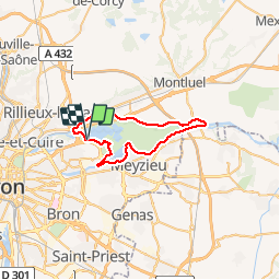
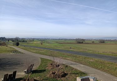
Tocht Mountainbike van 37 km beschikbaar op Auvergne-Rhône-Alpes, Métropole de Lyon, Vaulx-en-Velin. Deze tocht wordt voorgesteld door tracegps.
Beschrijving
Voici un circuit pour tourner les manivelles comme disent les routards, pas de montée. Au départ de planète Tonique, le centre de sport situé dans le parc de Miribel Jonage. Suivre dans un premier temps le parcours 5 jusqu'au pont de L'Ile puis chemin de halage le long du canal de Miribel, traverser le pont de Jons et retour par chemin de halage le long du canal de Jonage. Moi je préfère ensuite suivre la Rize quelques kilomètres mais vous pouvez continuer le long du Grand Large. A noter les rives gauches du canal de Jonage et du Grand Large sont réaménagées et la balade est encore plus agréable.
Plaatsbepaling
Opmerkingen
Wandeltochten in de omgeving
![Tocht Stappen Miribel - A_MIRIBEL 01700 La Droite - Brotteau de Crêt - Photo](https://media.geolcdn.com/t/375/260/ext.jpg?maxdim=2&url=https%3A%2F%2Fstatic1.geolcdn.com%2Fsiteimages%2Fupload%2Ffiles%2F1553511878bg_sport_marche.png)
![Stappen Stappen](https://static1.geolcdn.com/sitytour/trail-icons/101.png)
Stappen
![](/images/other/stat-length.png)
![](https://static1.geolcdn.com/siteimages/upload/files/16400158638029165_repeat_loop_refresh_sync_direction_icon.png)
![Tocht Stappen Miribel - 01_Madone_Miribel_12km190m - Photo](https://media.geolcdn.com/t/375/260/3808a987-c69f-4588-ac24-c5a887686b6d.jpg&format=jpg&maxdim=2)
![Stappen Stappen](https://static1.geolcdn.com/sitytour/trail-icons/101.png)
Stappen
![](/images/other/stat-length.png)
![](https://static1.geolcdn.com/siteimages/upload/files/16400158638029165_repeat_loop_refresh_sync_direction_icon.png)
![Tocht Stappen Miribel - 01-miribel-madone-13km250m - Photo](https://media.geolcdn.com/t/375/260/54e4913b-ef2a-418d-82cf-e68e6db6a21e.jpg&format=jpg&maxdim=2)
![Stappen Stappen](https://static1.geolcdn.com/sitytour/trail-icons/101.png)
Stappen
![](/images/other/stat-length.png)
![](https://static1.geolcdn.com/siteimages/upload/files/16400158638029165_repeat_loop_refresh_sync_direction_icon.png)
![Tocht Stappen Décines-Charpieu - 69-Meribel-grand-tour-du-lac-12km - Photo](https://media.geolcdn.com/t/375/260/2e4f960d-3d44-41ab-8096-3e5ef7efa37e.jpg&format=jpg&maxdim=2)
![Stappen Stappen](https://static1.geolcdn.com/sitytour/trail-icons/101.png)
Stappen
![](/images/other/stat-length.png)
![](https://static1.geolcdn.com/siteimages/upload/files/16400158638029165_repeat_loop_refresh_sync_direction_icon.png)
![Tocht Stappen Miribel - Miribel circuit de la Madone 02 - Photo](https://media.geolcdn.com/t/375/260/ext.jpg?maxdim=2&url=https%3A%2F%2Fstatic1.geolcdn.com%2Fsiteimages%2Fupload%2Ffiles%2F1553511878bg_sport_marche.png)
![Stappen Stappen](https://static1.geolcdn.com/sitytour/trail-icons/101.png)
Stappen
![](/images/other/stat-length.png)
![](https://static1.geolcdn.com/siteimages/upload/files/16400158638029165_repeat_loop_refresh_sync_direction_icon.png)
![Tocht Mountainbike Décines-Charpieu - Canal de Jonage et canal de Méribel - Photo](https://media.geolcdn.com/t/375/260/ext.jpg?maxdim=2&url=https%3A%2F%2Fstatic1.geolcdn.com%2Fsiteimages%2Fupload%2Ffiles%2F1524743154velo.jpg)
![Mountainbike Mountainbike](https://static1.geolcdn.com/sitytour/trail-icons/202.png)
Mountainbike
![](/images/other/stat-length.png)
![](https://static1.geolcdn.com/siteimages/upload/files/16400158638029165_repeat_loop_refresh_sync_direction_icon.png)
![Tocht Stappen Décines-Charpieu - Espace Biezin DECINES - Photo](https://media.geolcdn.com/t/375/260/9f842f2d-b514-4603-938c-3403b40d5761.jpg&format=jpg&maxdim=2)
![Stappen Stappen](https://static1.geolcdn.com/sitytour/trail-icons/101.png)
Stappen
![](/images/other/stat-length.png)
![](https://static1.geolcdn.com/siteimages/upload/files/16400158638029165_repeat_loop_refresh_sync_direction_icon.png)
![Tocht Wegfiets Villeurbanne - 69 vélo lyon - Photo](https://media.geolcdn.com/t/375/260/515a5c2c-5e74-4834-aaa7-44ef21c9b48a.jpg&format=jpg&maxdim=2)
![Wegfiets Wegfiets](https://static1.geolcdn.com/sitytour/trail-icons/201.png)
Wegfiets
![](/images/other/stat-length.png)
![](https://static1.geolcdn.com/siteimages/upload/files/16400158638029165_repeat_loop_refresh_sync_direction_icon.png)
![Tocht Mountainbike Décines-Charpieu - Le tour du parc Miribel - Photo](https://media.geolcdn.com/t/375/260/31c0dcc4-0455-4b1f-aa9a-0bd8c54c9d4d.jpg&format=jpg&maxdim=2)
![Mountainbike Mountainbike](https://static1.geolcdn.com/sitytour/trail-icons/202.png)
Mountainbike
![](/images/other/stat-length.png)
![](https://static1.geolcdn.com/siteimages/upload/files/16400158638029165_repeat_loop_refresh_sync_direction_icon.png)