![](/images/other/stat-length.png)
![Tocht Andere activiteiten Aberdeen - A Scottish Coast to Coast (Aberdeen to Fort William) - Photo](https://media.geolcdn.com/t/1900/400/ext.pjpeg?maxdim=2&url=https%3A%2F%2Fstatic1.geolcdn.com%2Fsiteimages%2Fupload%2Ffiles%2F1545311037marcheuse_200dpi.jpg)
A Scottish Coast to Coast (Aberdeen to Fort William)
vcoget
Gebruiker
![Lengte](/images/other/stat-length.png)
Lengte
281 km
![Max. hoogte](https://static1.geolcdn.com/siteimages/upload/files/1508320355ic_sort_altitude_max_24dp.png)
Max. hoogte
778 m
![Positief hoogteverschil](https://static1.geolcdn.com/siteimages/upload/files/1508320355ic_sort_den_pos_24dp.png)
Positief hoogteverschil
4046 m
![Km-Effort](/images/other/stat-length.png)
Km-Effort
335 km
![Min. hoogte](https://static1.geolcdn.com/siteimages/upload/files/1508320355ic_sort_altitude_min_24dp.png)
Min. hoogte
1 m
![Negatief hoogteverschil](https://static1.geolcdn.com/siteimages/upload/files/1508320355ic_sort_den_neg_24dp.png)
Negatief hoogteverschil
4048 m
![Boucle](https://static1.geolcdn.com/siteimages/upload/files/16400158638029165_repeat_loop_refresh_sync_direction_icon.png)
Boucle
Neen
Datum van aanmaak :
2019-01-16 10:35:41.073
Laatste wijziging :
2019-01-16 10:35:41.073
![Andere activiteiten](https://static1.geolcdn.com/sitytour/trail-icons/900.png)
--
Moeilijkheid : Onbekend
![Scan deze QR-code om de tocht te openen in de SityTrail-applicatie](https://capi.geolives.com/qq0zvz2zws4bq2lad0pu/sitytour/trails/1075986/qr.png?size=200)
Gratisgps-wandelapplicatie
Over ons
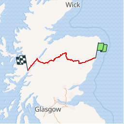
Tocht Andere activiteiten van 281 km beschikbaar op Schotland, Aberdeen City. Deze tocht wordt voorgesteld door vcoget.
Beschrijving
A Scottish coast to coast off road Mountain Bike route, some 175 miles long from Aberdeen to Fort William, inspired by an article by Rob Penn. A tough and challenging ride across some truly beautiful parts of Scotland....but not for the faint-hearted!
Plaatsbepaling
Land:
United Kingdom
Regio :
Schotland
Departement/Provincie :
Aberdeen City
Gemeente :
Aberdeen
Locatie:
Unknown
Vertrek:(Dec)
Vertrek:(UTM)
557027 ; 6332917 (30V) N.
Opmerkingen
Wandeltochten in de omgeving
![Tocht Te voet - Elsick Mounth - Photo](https://media.geolcdn.com/t/375/260/3aba790d-2ae1-4011-aaae-0403efb7aea8.jpeg&format=jpg&maxdim=2)
![Te voet Te voet](https://static1.geolcdn.com/sitytour/trail-icons/100.png)
Elsick Mounth
Te voet
Gemakkelijk
,
Schotland,
Aberdeenshire,
United Kingdom
![](/images/other/stat-length.png)
6,7 km | 9,3 km-effort
2h 6min
![](https://static1.geolcdn.com/siteimages/upload/files/16400158638029165_repeat_loop_refresh_sync_direction_icon.png)
Neen
![Tocht Te voet - Causey Mounth - Photo](https://media.geolcdn.com/t/375/260/d6e97be8-7239-481b-9167-4c9227fe11d3.jpeg&format=jpg&maxdim=2)
![Te voet Te voet](https://static1.geolcdn.com/sitytour/trail-icons/100.png)
Causey Mounth
Te voet
Gemakkelijk
,
Schotland,
Aberdeenshire,
United Kingdom
![](/images/other/stat-length.png)
7,7 km | 9,1 km-effort
2h 4min
![](https://static1.geolcdn.com/siteimages/upload/files/16400158638029165_repeat_loop_refresh_sync_direction_icon.png)
Neen
![Tocht Motor - 010 Stonehaven Braemar - Photo](https://media.geolcdn.com/t/375/260/ext.jpg?maxdim=2&url=https%3A%2F%2Fstatic1.geolcdn.com%2Fsiteimages%2Fupload%2Ffiles%2F15247431544x4.jpg)
![Motor Motor](https://static1.geolcdn.com/sitytour/trail-icons/400.png)
010 Stonehaven Braemar
Motor
Heel gemakkelijk
,
Schotland,
Aberdeenshire,
United Kingdom
![](/images/other/stat-length.png)
88 km | 135 km-effort
Onbekend
![](https://static1.geolcdn.com/siteimages/upload/files/16400158638029165_repeat_loop_refresh_sync_direction_icon.png)
Neen