![](/images/other/stat-length.png)
![Tocht Mountainbike Souleuvre-en-Bocage - La petite Besace - Saint Martin des Besaces - Photo](https://media.geolcdn.com/t/1900/400/ext.pjpeg?maxdim=2&url=https%3A%2F%2Fstatic1.geolcdn.com%2Fsiteimages%2Fupload%2Ffiles%2F1524743154velo.jpg)
La petite Besace - Saint Martin des Besaces
tracegps
Gebruiker
![Lengte](/images/other/stat-length.png)
Lengte
37 km
![Max. hoogte](https://static1.geolcdn.com/siteimages/upload/files/1508320355ic_sort_altitude_max_24dp.png)
Max. hoogte
239 m
![Positief hoogteverschil](https://static1.geolcdn.com/siteimages/upload/files/1508320355ic_sort_den_pos_24dp.png)
Positief hoogteverschil
762 m
![Km-Effort](/images/other/stat-length.png)
Km-Effort
47 km
![Min. hoogte](https://static1.geolcdn.com/siteimages/upload/files/1508320355ic_sort_altitude_min_24dp.png)
Min. hoogte
77 m
![Negatief hoogteverschil](https://static1.geolcdn.com/siteimages/upload/files/1508320355ic_sort_den_neg_24dp.png)
Negatief hoogteverschil
762 m
![Boucle](https://static1.geolcdn.com/siteimages/upload/files/16400158638029165_repeat_loop_refresh_sync_direction_icon.png)
Boucle
Ja
Datum van aanmaak :
2014-12-10 00:00:00.0
Laatste wijziging :
2014-12-10 00:00:00.0
![Mountainbike](https://static1.geolcdn.com/sitytour/trail-icons/202.png)
3h00
Moeilijkheid : Moeilijk
![Scan deze QR-code om de tocht te openen in de SityTrail-applicatie](https://capi.geolives.com/qq0zvz2zws4bq2lad0pu/sitytour/trails/107272/qr.png?size=200)
Gratisgps-wandelapplicatie
Over ons
Tocht Mountainbike van 37 km beschikbaar op Normandië, Calvados, Souleuvre-en-Bocage. Deze tocht wordt voorgesteld door tracegps.
Beschrijving
Circuit très sympa avec très peu de passage routier, quelques single tracks sympas et des montées difficiles. Attention circuit pour vététistes confirmés. Bon ride !!!
Plaatsbepaling
Land:
France
Regio :
Normandië
Departement/Provincie :
Calvados
Gemeente :
Souleuvre-en-Bocage
Locatie:
Unknown
Vertrek:(Dec)
Vertrek:(UTM)
657577 ; 5430843 (30U) N.
Opmerkingen
Wandeltochten in de omgeving
![Tocht Mountainbike Souleuvre-en-Bocage - Tour du Bocage Virois - Saint Martin des Besaces - Photo](https://media.geolcdn.com/t/375/260/ext.jpg?maxdim=2&url=https%3A%2F%2Fservices.sitytrail.com%2FGeolivesWS%2FDownloadMedia.ashx%3FTrailID%3D172576%26Media%3D13944_2.jpg)
![Mountainbike Mountainbike](https://static1.geolcdn.com/sitytour/trail-icons/202.png)
Tour du Bocage Virois - Saint Martin des Besaces
Mountainbike
Zeer moeilijk
Souleuvre-en-Bocage,
Normandië,
Calvados,
France
![](/images/other/stat-length.png)
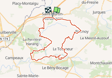
62 km | 78 km-effort
4h 30min
![](https://static1.geolcdn.com/siteimages/upload/files/16400158638029165_repeat_loop_refresh_sync_direction_icon.png)
Ja
![Tocht Fietstoerisme Souleuvre-en-Bocage - Activity - Photo](https://media.geolcdn.com/t/375/260/ext.jpg?maxdim=2&url=https%3A%2F%2Fstatic1.geolcdn.com%2Fsiteimages%2Fupload%2Ffiles%2F1524743154velo.jpg)
![Fietstoerisme Fietstoerisme](https://static1.geolcdn.com/sitytour/trail-icons/204.png)
Activity
Fietstoerisme
Medium
Souleuvre-en-Bocage,
Normandië,
Calvados,
France
![](/images/other/stat-length.png)
18,2 km | 21 km-effort
Onbekend
![](https://static1.geolcdn.com/siteimages/upload/files/16400158638029165_repeat_loop_refresh_sync_direction_icon.png)
Neen
![Tocht Stappen Brémoy - bremoy2 - Photo](https://media.geolcdn.com/t/375/260/ext.jpg?maxdim=2&url=https%3A%2F%2Fstatic1.geolcdn.com%2Fsiteimages%2Fupload%2Ffiles%2F1553511878bg_sport_marche.png)
![Stappen Stappen](https://static1.geolcdn.com/sitytour/trail-icons/101.png)
![Tocht Mountainbike Souleuvre-en-Bocage - La Souleuvre - Saint Martin des Besaces - Photo](https://media.geolcdn.com/t/375/260/ext.jpg?maxdim=2&url=https%3A%2F%2Fstatic1.geolcdn.com%2Fsiteimages%2Fupload%2Ffiles%2F1524743154velo.jpg)
![Mountainbike Mountainbike](https://static1.geolcdn.com/sitytour/trail-icons/202.png)
La Souleuvre - Saint Martin des Besaces
Mountainbike
Zeer moeilijk
Souleuvre-en-Bocage,
Normandië,
Calvados,
France
![](/images/other/stat-length.png)
52 km | 67 km-effort
4h 0min
![](https://static1.geolcdn.com/siteimages/upload/files/16400158638029165_repeat_loop_refresh_sync_direction_icon.png)
Ja
![Tocht Te voet Brémoy - brémoy - Photo](https://media.geolcdn.com/t/375/260/ext.jpg?maxdim=2&url=https%3A%2F%2Fstatic1.geolcdn.com%2Fsiteimages%2Fupload%2Ffiles%2F1545311037marcheuse_200dpi.jpg)
![Te voet Te voet](https://static1.geolcdn.com/sitytour/trail-icons/100.png)
brémoy
Te voet
Heel gemakkelijk
Brémoy,
Normandië,
Calvados,
France
![](/images/other/stat-length.png)
9,6 km | 12 km-effort
Onbekend
![](https://static1.geolcdn.com/siteimages/upload/files/16400158638029165_repeat_loop_refresh_sync_direction_icon.png)
Ja
![Tocht 4x4 Souleuvre-en-Bocage - Sortie du samedi 14 mars - Photo](https://media.geolcdn.com/t/375/260/ext.jpg?maxdim=2&url=https%3A%2F%2Fstatic1.geolcdn.com%2Fsiteimages%2Fupload%2Ffiles%2F15247431544x4.jpg)
![4x4 4x4](https://static1.geolcdn.com/sitytour/trail-icons/403.png)
Sortie du samedi 14 mars
4x4
Souleuvre-en-Bocage,
Normandië,
Calvados,
France
![](/images/other/stat-length.png)
63 km | 74 km-effort
2h 31min
![](https://static1.geolcdn.com/siteimages/upload/files/16400158638029165_repeat_loop_refresh_sync_direction_icon.png)
Ja
![Tocht 4x4 Souleuvre-en-Bocage - Promenade 3 - Photo](https://media.geolcdn.com/t/375/260/ext.jpg?maxdim=2&url=https%3A%2F%2Fstatic1.geolcdn.com%2Fsiteimages%2Fupload%2Ffiles%2F15247431544x4.jpg)
![4x4 4x4](https://static1.geolcdn.com/sitytour/trail-icons/403.png)
Promenade 3
4x4
Souleuvre-en-Bocage,
Normandië,
Calvados,
France
![](/images/other/stat-length.png)
16 km | 19,6 km-effort
1h 58min
![](https://static1.geolcdn.com/siteimages/upload/files/16400158638029165_repeat_loop_refresh_sync_direction_icon.png)
Neen
![Tocht 4x4 Souleuvre-en-Bocage - Vent Bocage 10 mars 2020 - Photo](https://media.geolcdn.com/t/375/260/ext.jpg?maxdim=2&url=https%3A%2F%2Fstatic1.geolcdn.com%2Fsiteimages%2Fupload%2Ffiles%2F15247431544x4.jpg)
![4x4 4x4](https://static1.geolcdn.com/sitytour/trail-icons/403.png)
Vent Bocage 10 mars 2020
4x4
Souleuvre-en-Bocage,
Normandië,
Calvados,
France
![](/images/other/stat-length.png)
45 km | 57 km-effort
2h 10min
![](https://static1.geolcdn.com/siteimages/upload/files/16400158638029165_repeat_loop_refresh_sync_direction_icon.png)
Ja
![Tocht Stappen Souleuvre-en-Bocage - St Denis maisoncelles - Photo](https://media.geolcdn.com/t/375/260/ext.jpg?maxdim=2&url=https%3A%2F%2Fstatic1.geolcdn.com%2Fsiteimages%2Fupload%2Ffiles%2F1553511878bg_sport_marche.png)
![Stappen Stappen](https://static1.geolcdn.com/sitytour/trail-icons/101.png)
St Denis maisoncelles
Stappen
Heel gemakkelijk
Souleuvre-en-Bocage,
Normandië,
Calvados,
France
![](/images/other/stat-length.png)
12,9 km | 15,9 km-effort
3h 19min
![](https://static1.geolcdn.com/siteimages/upload/files/16400158638029165_repeat_loop_refresh_sync_direction_icon.png)
Ja