![](/images/other/stat-length.png)
![Tocht Stappen Conques-en-Rouergue - La Vinzelle - Grand Vabre - Photo](https://media.geolcdn.com/t/1900/400/ext.pjpeg?maxdim=2&url=https%3A%2F%2Fservices.sitytrail.com%2FGeolivesWS%2FDownloadMedia.ashx%3FTrailID%3D107259%26Media%3D12139_6.jpg)
La Vinzelle - Grand Vabre
tracegps
Gebruiker
![Lengte](/images/other/stat-length.png)
Lengte
6,7 km
![Max. hoogte](https://static1.geolcdn.com/siteimages/upload/files/1508320355ic_sort_altitude_max_24dp.png)
Max. hoogte
489 m
![Positief hoogteverschil](https://static1.geolcdn.com/siteimages/upload/files/1508320355ic_sort_den_pos_24dp.png)
Positief hoogteverschil
325 m
![Km-Effort](/images/other/stat-length.png)
Km-Effort
11,1 km
![Min. hoogte](https://static1.geolcdn.com/siteimages/upload/files/1508320355ic_sort_altitude_min_24dp.png)
Min. hoogte
194 m
![Negatief hoogteverschil](https://static1.geolcdn.com/siteimages/upload/files/1508320355ic_sort_den_neg_24dp.png)
Negatief hoogteverschil
326 m
![Boucle](https://static1.geolcdn.com/siteimages/upload/files/16400158638029165_repeat_loop_refresh_sync_direction_icon.png)
Boucle
Ja
Datum van aanmaak :
2014-12-10 00:00:00.0
Laatste wijziging :
2014-12-10 00:00:00.0
![Stappen](https://static1.geolcdn.com/sitytour/trail-icons/101.png)
3h30
Moeilijkheid : Medium
![Scan deze QR-code om de tocht te openen in de SityTrail-applicatie](https://capi.geolives.com/qq0zvz2zws4bq2lad0pu/sitytour/trails/107259/qr.png?size=200)
Gratisgps-wandelapplicatie
Over ons
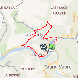
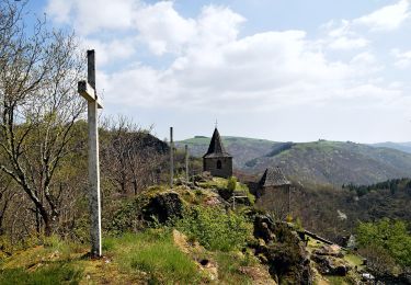
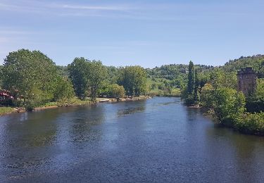
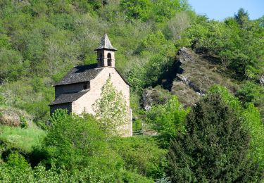
Tocht Stappen van 6,7 km beschikbaar op Occitanië, Aveyron, Conques-en-Rouergue. Deze tocht wordt voorgesteld door tracegps.
Beschrijving
Jolie randonnée, très beaux sentiers escarpés, village classé de la Vinzelle avec possibilité de rallonger la randonnée. Au départ du village, une boucle 45 minutes et un balisage jaune plus panneaux.
Plaatsbepaling
Land:
France
Regio :
Occitanië
Departement/Provincie :
Aveyron
Gemeente :
Conques-en-Rouergue
Locatie:
Grand-Vabre
Vertrek:(Dec)
Vertrek:(UTM)
448591 ; 4942660 (31T) N.
Opmerkingen
Wandeltochten in de omgeving
![Tocht Stappen Conques-en-Rouergue - Les Pelies La Vinzelle : boucle rapide - Photo](https://media.geolcdn.com/t/375/260/ext.jpg?maxdim=2&url=https%3A%2F%2Fservices.sitytrail.com%2FGeolivesWS%2FDownloadMedia.ashx%3FTrailID%3D815525%26Media%3D20170822112933.jpg)
![Stappen Stappen](https://static1.geolcdn.com/sitytour/trail-icons/101.png)
Les Pelies La Vinzelle : boucle rapide
Stappen
Gemakkelijk
(1)
Conques-en-Rouergue,
Occitanië,
Aveyron,
France
![](/images/other/stat-length.png)
5,4 km | 8,8 km-effort
3h 19min
![](https://static1.geolcdn.com/siteimages/upload/files/16400158638029165_repeat_loop_refresh_sync_direction_icon.png)
Ja
![Tocht Te voet Conques-en-Rouergue - TerraTrail 7 - Photo](https://media.geolcdn.com/t/375/260/a3c72d09-9e84-4bb5-99d1-f393f2772e29.jpeg&format=jpg&maxdim=2)
![Te voet Te voet](https://static1.geolcdn.com/sitytour/trail-icons/100.png)
TerraTrail 7
Te voet
Gemakkelijk
Conques-en-Rouergue,
Occitanië,
Aveyron,
France
![](/images/other/stat-length.png)
9,4 km | 15,8 km-effort
3h 36min
![](https://static1.geolcdn.com/siteimages/upload/files/16400158638029165_repeat_loop_refresh_sync_direction_icon.png)
Ja
![Tocht Te voet Conques-en-Rouergue - Terra trail 10 - Photo](https://media.geolcdn.com/t/375/260/c1627d11-6231-43ca-9a1f-6c8b11a3fcd5.jpeg&format=jpg&maxdim=2)
![Te voet Te voet](https://static1.geolcdn.com/sitytour/trail-icons/100.png)
Terra trail 10
Te voet
Moeilijk
Conques-en-Rouergue,
Occitanië,
Aveyron,
France
![](/images/other/stat-length.png)
22 km | 34 km-effort
7h 41min
![](https://static1.geolcdn.com/siteimages/upload/files/16400158638029165_repeat_loop_refresh_sync_direction_icon.png)
Ja
![Tocht Stappen Conques-en-Rouergue - Conques Levinhac le Haut Avril 2018 - Photo](https://media.geolcdn.com/t/375/260/ext.jpg?maxdim=2&url=https%3A%2F%2Fservices.sitytrail.com%2FGeolivesWS%2FDownloadMedia.ashx%3FTrailID%3D954999%26Media%3Dfix__20180426142306.jpg)
![Stappen Stappen](https://static1.geolcdn.com/sitytour/trail-icons/101.png)
Conques Levinhac le Haut Avril 2018
Stappen
Moeilijk
Conques-en-Rouergue,
Occitanië,
Aveyron,
France
![](/images/other/stat-length.png)
25 km | 36 km-effort
7h 4min
![](https://static1.geolcdn.com/siteimages/upload/files/16400158638029165_repeat_loop_refresh_sync_direction_icon.png)
Neen
![Tocht Stappen Conques-en-Rouergue - Conques - Photo](https://media.geolcdn.com/t/375/260/b1ba52c1-bc17-4a66-9751-be2d2d70e0b7.jpg&format=jpg&maxdim=2)
![Stappen Stappen](https://static1.geolcdn.com/sitytour/trail-icons/101.png)
Conques
Stappen
Heel gemakkelijk
Conques-en-Rouergue,
Occitanië,
Aveyron,
France
![](/images/other/stat-length.png)
10,9 km | 16,3 km-effort
3h 2min
![](https://static1.geolcdn.com/siteimages/upload/files/16400158638029165_repeat_loop_refresh_sync_direction_icon.png)
Ja
![Tocht Te voet Conques-en-Rouergue - Sentier Conques - Grand-Vabre - Photo](https://media.geolcdn.com/t/375/260/54393b8a-3c65-496a-ad24-69e3b20f1258.jpeg&format=jpg&maxdim=2)
![Te voet Te voet](https://static1.geolcdn.com/sitytour/trail-icons/100.png)
Sentier Conques - Grand-Vabre
Te voet
Gemakkelijk
Conques-en-Rouergue,
Occitanië,
Aveyron,
France
![](/images/other/stat-length.png)
4,9 km | 6,4 km-effort
1h 27min
![](https://static1.geolcdn.com/siteimages/upload/files/16400158638029165_repeat_loop_refresh_sync_direction_icon.png)
Neen
![Tocht Te voet Conques-en-Rouergue - Tieulet - Photo](https://media.geolcdn.com/t/375/260/81ea3ff4-8db3-4406-ab2f-734b1935602f.jpeg&format=jpg&maxdim=2)
![Te voet Te voet](https://static1.geolcdn.com/sitytour/trail-icons/100.png)
Tieulet
Te voet
Gemakkelijk
(1)
Conques-en-Rouergue,
Occitanië,
Aveyron,
France
![](/images/other/stat-length.png)
6,6 km | 10,5 km-effort
2h 22min
![](https://static1.geolcdn.com/siteimages/upload/files/16400158638029165_repeat_loop_refresh_sync_direction_icon.png)
Neen
![Tocht Te voet Conques-en-Rouergue - Chapelle Sainte-Foy - Photo](https://media.geolcdn.com/t/375/260/434a867d-228b-48bc-b18b-156cab88645d.jpeg&format=jpg&maxdim=2)
![Te voet Te voet](https://static1.geolcdn.com/sitytour/trail-icons/100.png)
Chapelle Sainte-Foy
Te voet
Gemakkelijk
Conques-en-Rouergue,
Occitanië,
Aveyron,
France
![](/images/other/stat-length.png)
5,8 km | 10,4 km-effort
2h 22min
![](https://static1.geolcdn.com/siteimages/upload/files/16400158638029165_repeat_loop_refresh_sync_direction_icon.png)
Neen
![Tocht Stappen Conques-en-Rouergue - Conques - Photo](https://media.geolcdn.com/t/375/260/32cd5116-ab43-4910-8d1a-8e95108c73de.jpg&format=jpg&maxdim=2)
![Stappen Stappen](https://static1.geolcdn.com/sitytour/trail-icons/101.png)
Conques
Stappen
Medium
Conques-en-Rouergue,
Occitanië,
Aveyron,
France
![](/images/other/stat-length.png)
5,8 km | 10,2 km-effort
2h 4min
![](https://static1.geolcdn.com/siteimages/upload/files/16400158638029165_repeat_loop_refresh_sync_direction_icon.png)
Ja
avec auberge à la vinzelle