![](/images/other/stat-length.png)
![Tocht Mountainbike Yvoir - GODINNE ... par Fidevoye et le Bois de Godinne. - Photo](https://media.geolcdn.com/t/1900/400/ext.pjpeg?maxdim=2&url=https%3A%2F%2Fservices.sitytrail.com%2FGeolivesWS%2FDownloadMedia.ashx%3FTrailID%3D1071040%26Media%3Dfix__20181113141925.jpg)
GODINNE ... par Fidevoye et le Bois de Godinne.
GerardBouche
Gebruiker
![Lengte](/images/other/stat-length.png)
Lengte
10 km
![Max. hoogte](https://static1.geolcdn.com/siteimages/upload/files/1508320355ic_sort_altitude_max_24dp.png)
Max. hoogte
272 m
![Positief hoogteverschil](https://static1.geolcdn.com/siteimages/upload/files/1508320355ic_sort_den_pos_24dp.png)
Positief hoogteverschil
282 m
![Km-Effort](/images/other/stat-length.png)
Km-Effort
13,8 km
![Min. hoogte](https://static1.geolcdn.com/siteimages/upload/files/1508320355ic_sort_altitude_min_24dp.png)
Min. hoogte
77 m
![Negatief hoogteverschil](https://static1.geolcdn.com/siteimages/upload/files/1508320355ic_sort_den_neg_24dp.png)
Negatief hoogteverschil
281 m
![Boucle](https://static1.geolcdn.com/siteimages/upload/files/16400158638029165_repeat_loop_refresh_sync_direction_icon.png)
Boucle
Ja
Datum van aanmaak :
2019-01-15 18:47:26.25
Laatste wijziging :
2019-01-15 18:47:26.25
![Mountainbike](https://static1.geolcdn.com/sitytour/trail-icons/202.png)
53m
Moeilijkheid : Gemakkelijk
![Scan deze QR-code om de tocht te openen in de SityTrail-applicatie](https://capi.geolives.com/qq0zvz2zws4bq2lad0pu/sitytour/trails/1071040/qr.png?size=200)
Gratisgps-wandelapplicatie
Over ons
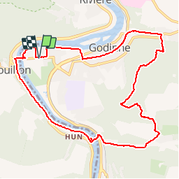
Tocht Mountainbike van 10 km beschikbaar op Wallonië, Namen, Yvoir. Deze tocht wordt voorgesteld door GerardBouche.
Beschrijving
Depuis la flèche Brisée par la rive gauche de la Meuse, l'écluse de Fidevoye, la Ferme d'Anway, le Bois de Godinne et descente par le sentier réhabilité du "Fossey dô Leu".
Plaatsbepaling
Land:
Belgium
Regio :
Wallonië
Departement/Provincie :
Namen
Gemeente :
Yvoir
Locatie:
Godinne
Vertrek:(Dec)
Vertrek:(UTM)
632231 ; 5579070 (31U) N.
Opmerkingen
Wandeltochten in de omgeving
![Tocht Stappen Profondeville - GG-Na-19_ Lustin - Namur - Photo](https://media.geolcdn.com/t/375/260/b0b5ef2e-bf0c-4965-a3a2-62d0da2d07c7.jpg&format=jpg&maxdim=2)
![Stappen Stappen](https://static1.geolcdn.com/sitytour/trail-icons/101.png)
GG-Na-19_ Lustin - Namur
Stappen
Zeer moeilijk
(13)
Profondeville,
Wallonië,
Namen,
Belgium
![](/images/other/stat-length.png)
22 km | 28 km-effort
6h 7min
![](https://static1.geolcdn.com/siteimages/upload/files/16400158638029165_repeat_loop_refresh_sync_direction_icon.png)
Neen
![Tocht Stappen Anhée - RB-Na-22-raccourci_Vignobles-et-Jardins-d’eau - Photo](https://media.geolcdn.com/t/375/260/9e39c4d6-ac1b-4acf-9686-7baae428f1a0.jpg&format=jpg&maxdim=2)
![Stappen Stappen](https://static1.geolcdn.com/sitytour/trail-icons/101.png)
RB-Na-22-raccourci_Vignobles-et-Jardins-d’eau
Stappen
Zeer moeilijk
(6)
Anhée,
Wallonië,
Namen,
Belgium
![](/images/other/stat-length.png)
16,7 km | 21 km-effort
4h 52min
![](https://static1.geolcdn.com/siteimages/upload/files/16400158638029165_repeat_loop_refresh_sync_direction_icon.png)
Ja
![Tocht Stappen Anhée - RB-Na-22_Vignobles-et-Jardins-d’eau - Photo](https://media.geolcdn.com/t/375/260/8622883f-03f3-4eff-8458-0cb9f1aba19e.jpg&format=jpg&maxdim=2)
![Stappen Stappen](https://static1.geolcdn.com/sitytour/trail-icons/101.png)
RB-Na-22_Vignobles-et-Jardins-d’eau
Stappen
Zeer moeilijk
(11)
Anhée,
Wallonië,
Namen,
Belgium
![](/images/other/stat-length.png)
19,5 km | 25 km-effort
5h 46min
![](https://static1.geolcdn.com/siteimages/upload/files/16400158638029165_repeat_loop_refresh_sync_direction_icon.png)
Ja
![Stappen Stappen](https://static1.geolcdn.com/sitytour/trail-icons/101.png)
RB-Na-21-Terres seigneuriales et carrières de la vallée du Bocq
Stappen
Zeer moeilijk
(6)
Yvoir,
Wallonië,
Namen,
Belgium
![](/images/other/stat-length.png)
22 km | 30 km-effort
6h 51min
![](https://static1.geolcdn.com/siteimages/upload/files/16400158638029165_repeat_loop_refresh_sync_direction_icon.png)
Ja
![Stappen Stappen](https://static1.geolcdn.com/sitytour/trail-icons/101.png)
RB-Na-20-Raccourci-2_Paysages_entre_Meuse_et_Burnot
Stappen
Zeer moeilijk
(11)
Profondeville,
Wallonië,
Namen,
Belgium
![](/images/other/stat-length.png)
14,6 km | 22 km-effort
4h 53min
![](https://static1.geolcdn.com/siteimages/upload/files/16400158638029165_repeat_loop_refresh_sync_direction_icon.png)
Ja
![Stappen Stappen](https://static1.geolcdn.com/sitytour/trail-icons/101.png)
RB-Na-20-Paysages_entre_Meuse_et_Burnot
Stappen
Zeer moeilijk
(16)
Profondeville,
Wallonië,
Namen,
Belgium
![](/images/other/stat-length.png)
18,5 km | 26 km-effort
5h 55min
![](https://static1.geolcdn.com/siteimages/upload/files/16400158638029165_repeat_loop_refresh_sync_direction_icon.png)
Ja
![Tocht Stappen Yvoir - GG2-Na-38_Godinne-Dinant (2021-11-04) - Photo](https://media.geolcdn.com/t/375/260/4b7f8162-b405-4557-afe1-7567462c4aff.jpg&format=jpg&maxdim=2)
![Stappen Stappen](https://static1.geolcdn.com/sitytour/trail-icons/101.png)
GG2-Na-38_Godinne-Dinant (2021-11-04)
Stappen
Zeer moeilijk
(6)
Yvoir,
Wallonië,
Namen,
Belgium
![](/images/other/stat-length.png)
19,5 km | 27 km-effort
6h 13min
![](https://static1.geolcdn.com/siteimages/upload/files/16400158638029165_repeat_loop_refresh_sync_direction_icon.png)
Neen
![Tocht Stappen Anhée - RF-Na-05 Annevoie, côté Jardins_Grande-boucle - Photo](https://media.geolcdn.com/t/375/260/ext.jpg?maxdim=2&url=https%3A%2F%2Fservices.sitytrail.com%2FGeolivesWS%2FDownloadMedia.ashx%3FTrailID%3D545753%26Media%3D5d973c83-4a6c-40fc-a026-25de6c754887.JPG)
![Stappen Stappen](https://static1.geolcdn.com/sitytour/trail-icons/101.png)
RF-Na-05 Annevoie, côté Jardins_Grande-boucle
Stappen
Medium
(11)
Anhée,
Wallonië,
Namen,
Belgium
![](/images/other/stat-length.png)
11,3 km | 14,5 km-effort
3h 6min
![](https://static1.geolcdn.com/siteimages/upload/files/16400158638029165_repeat_loop_refresh_sync_direction_icon.png)
Ja
![Tocht Stappen Anhée - RF-Na-05 Annevoie, côté Jardins_Petite-boucle - Photo](https://media.geolcdn.com/t/375/260/ext.jpg?maxdim=2&url=https%3A%2F%2Fservices.sitytrail.com%2FGeolivesWS%2FDownloadMedia.ashx%3FTrailID%3D545751%26Media%3D5d973c83-4a6c-40fc-a026-25de6c754887.JPG)
![Stappen Stappen](https://static1.geolcdn.com/sitytour/trail-icons/101.png)
RF-Na-05 Annevoie, côté Jardins_Petite-boucle
Stappen
Gemakkelijk
(7)
Anhée,
Wallonië,
Namen,
Belgium
![](/images/other/stat-length.png)
7,4 km | 10 km-effort
2h 7min
![](https://static1.geolcdn.com/siteimages/upload/files/16400158638029165_repeat_loop_refresh_sync_direction_icon.png)
Ja